
This item below is out of stock, but another example (left) is available. To view the available item, click "Details."
Details
1817 Thomson Map of Africa
1817 (undated) $350.00
1813 Thomson Map of Africa
Africa-thomson-1813$175.00

Title
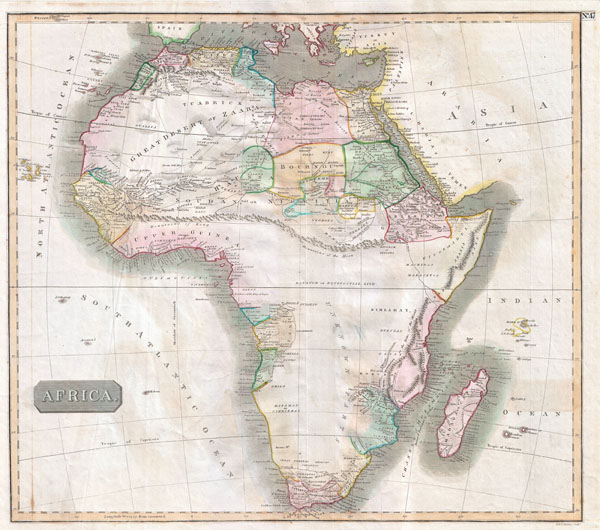
Africa
1813 (undated) 19 x 22 in (48.26 x 55.88 cm) 1 : 20000000
1813 (undated) 19 x 22 in (48.26 x 55.88 cm) 1 : 20000000
Description
This hand colored map is a steel plate engraving, dating to 1813 by the important English mapmaker John Thomson. It is an early and historically important representation of the continent of Africa. Much of the continent is simply labeled 'unknown parts,' but some regions are surprisingly detailed. Caravan routes, temples, and even the distances between Oases are noted. Across the center of the continent Thomson details the mythical mountain range known as the 'Mountains of the Moon.' The Mountains of the Moon were first postulated by Ptolemy to be the source of the Nile in the 2nd Century AD. This mysterious range remained on maps until the mid 19th century explorations of Burton, Speke, and Livingstone. Today it is generally agreed that references to the Mountains of the Moon refer to the Ruwenzori Range of Kenya & Uganda. This mountain range remains one of the most remote and exotic places on Earth, and is the home of a diversity of bizarre plant and animal life. Even so, it is not, as postulated, the source of the Nile which lies just to the south in Lake Victoria. Neither Lake Victoria nor Lake Tanganyika appear on this map. Thomson maps are known for their stunning color, awe inspiring size, and magnificent detail. Thomson's work, including this map, represents some of the finest cartographic art of the 19th century.
CartographerS
John Thomson (1777 - c. 1841) was a Scottish cartographer, publisher, and bookbinder active in Edinburgh during the early part of the 19th century. Thomson apprenticed under Edinburgh bookbinder Robert Alison. After his apprenticeship, he briefly went into business with Abraham Thomson. Later, the two parted ways, John Thomson segueing into maps and Abraham Thomson taking over the bookbinding portion of the business. Thomson is generally one of the leading publishers in the Edinburgh school of cartography, which flourished from roughly 1800 to 1830. Thomson and his contemporaries (Pinkerton and Cary) redefined European cartography by abandoning typical 18th-century decorative elements such as elaborate title cartouches and fantastic beasts in favor of detail and accuracy. Thomson's principle works include Thomson's New General Atlas, published from 1814 to 1821, the New Classical and Historical Atlas of 1829, and his 1830 Atlas of Scotland. The Atlas of Scotland, a work of groundbreaking detail and dedication, would eventually bankrupt the Thomson firm in 1830, at which time their plates were sequestered by the court. The firm partially recovered in the subsequent year, allowing Thomson to reclaim his printing plates in 1831, but filed again for bankruptcy in 1835, at which time most of his printing plates were sold to A. K. Johnston and Company. There is some suggestion that he continued to work as a bookbinder until 1841. Today, Thomson maps are becoming increasingly rare as they are highly admired for their impressive size, vivid hand coloration, and superb detail. More by this mapmaker...
John Menzies (October 27, 1772 - October 16, 1857) was a Scottish engraver active in Edinburgh during the late 18th and early 19th centuries. Menzies mastered engraving as an apprentice to James Rymer. In 1811, he partnered with his younger brother, George Menzies, to found the engraving firm of J. and G. Menzies, which was active until about 1831. Later his son, also named John, joined the firm and they engraved jointly under the imprint of J. Menzies and Son. At its height, the Menzies firm employed three men and three apprentices. Menzies engraved maps for Thomas Brown and John Thomson, among others. After his death, his son, John Menzies II (1819 – 1891), continued the family business until about 1891. Learn More...
Source
Thomson, J., A New General Atlas, (Edinburgh) 1817.
Thomson's New General Atlas was first published in 1817 and continued to be published until about 1821. This is the first of Thomson's major cartographic works and the atlas for which is most celebrated. The New General Atlas follows in the Edinburgh School, which eschews excessive decoration in favor of a more minimalistic fact-based cartographic vision, as established by John Pinkerton, Laurie and Whittle, John Cary, and others in the previous decades. The maps are notable for their massive scale, heavy stock, elegant color work, and easy-to-read typefaces. Although the atlas stopped being published after 1821, Thomson continued to offer 'supplementary' maps that could be tipped into the atlas as late as 1830, when he declared bankruptcy. The maps in the Thomson Atlas were engraved by Thomas Clerk, William Dassauville, Nathaniel Rogers Hewitt, James Kirkwood, Robert Kirkwood, John Menzies, George Menzies, Edward Mitchell, John Moffatt, Samuel John Neele, Robert Scott, and James Wyld.
Condition
Very good condition. Original centerfold. Minor offsetting. Some minor creasing on the left side of the map - see image.
References
Rumsey 1007.051 (1817 edition). Tooley, R.V., Maps of Africa, p. 101 (1817 edition).