
1593 Cornelis De Jode Map of Africa

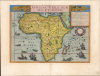
Africae Vera Forma, et Situs.
Most unique atlas map of Africa to appear in the 16th century.
- Digital Map Information
- Suitable for large format printing
- Full resolution TIFF file
- ICC color profile embedded
- Delivered instantly via download link
Most unique atlas map of Africa to appear in the 16th century.
This is Cornelis De Jode's superb, rare map of Africa, printed in a single edition of 1593. It is the most unique atlas map of Africa to appear in the 16th century, being the only such based on Petrus Plancius' 1592 wall map of the world.A Closer Look
This map replaces the more spartan 1573 map of Gerard De Jode. The bold title banner and the ornate strapwork frame a most engaging map, and the enclosing seas teem with ships and monsters. This map has been embellished with 13 human figures garbed to represent African peoples; a foreshadowing of the cartes à figures which would captivate map-readers in the subsequent century. This is thus the most ornate 16th-century folio map of Africa.These novel elements adorn a map drawn from a newer authority than any other. The predecessors to this map - Ortelius, Mercator, and Gerard De Jode - had all relied primarily on the model set by Giacomo Gastaldi. (The elder De Jode's map was itself a faithful reduction of Gastaldi's 1564 wall map.) Convention holds that Cornelis' new map was modeled on Mercator's 1569 wall map of the world; a puzzling claim, since a few minutes' comparison of the two reveals more differences than similarities. The startling differences between the two maps' delineations of the Niger River and their depictions of the Ptolemaic lakes at the source of the Nile should dispel any such misconception.
The present map's depiction of Madagascar diverges from any other that we have seen from this period; those that appear on the Ortelius and Mercator are rather featureless oblongs. While Gastaldi's featured a better delineation of the west coast than many of his followers, the many bays and inlets of De Jode's new map advertise a different source. Also, its interior contains a 'Silva lignoru sandali' (sandalwood forest), which is absent on any of the precursors usually ascribed to this map.
The west coast of South Africa also includes an inlet titled G. de S. Ellena: the Gulf (or Bay) of St. Helena. This was the location of a 17th-century Dutch outpost, and it was noted as the location where Vasco de Gama landed in 1497. Despite its appearance on Waldseemüller's 1513 map of southern Africa, it was subsequently unrecorded on the maps of Mercator, Ortelius, and Gastaldi. Where does it come from?
Through a Glass Darkly
When Cornelis De Jode set about producing a new edition of his father's atlas, he added ten newly-engraved and sourced maps in an effort to bring the work up to date, and to make it competitive with Ortelius' Goliath work. These included maps of the continents, which share this map's cylindrical projection and decorative elements. These closely correspond in outline to the respective continents appearing in Petrus Plancius' 1592 wall map Nova et Exacta Terrarum Orbis Tabula Geographica ac Hydrographica. The similarity is most apparent in North America and Europe, owing to the peculiar distortion of those continents resulting from the cylindrical projection used by Plancius; the outline of the 1593 Africa is derived from Plancius.The finer details we would consult to support the connection of this map and the Plancius are denied us. The 1592 wall map survives in a single, badly damaged copy at the Colegio del Corpus Cristi Valencia, and the images of the 18-sheet work that have been made publicly available are of deplorably low resolution. That, combined with the overall condition of the work, makes it impossible to determine (for example) if De Jode's Silva lignoru sandali originated with the Plancius. That said, the outline of Madagascar appearing on each map suggests a close relationship, and the inlet of G. de S. Ellena can also be identified on the Plancius. Finally, the shapes of the Ptolemaic lakes connected to the Nile are very similar between the De Jode and the Plancius, while being entirely dissimilar to those presented by either Mercator on his 1569 map, or Gastaldi on his 1564 Africa.
Richly Embellished
Cornelis understood that improved detail alone would be insufficient to challenge Ortelius' market dominance. He thus anticipated the mapmakers of the Dutch Golden Age by elaborating his maps with graphic imagery to better illustrate the relevant subject areas, particularly with the native figures mentioned above. He also included an array of text notes in the map's body. One notes the Amara Mountains, where the sons of the Emperor of Ethiopia are said to be imprisoned. (Surprisingly, De Jode does not identify the Emperor as Prester John.) Another describes an astonishing passage under the mountains, through which the River Niger runs for 50 miles. In the legendary lake Zaire, an annotation mentions the presence there both of Tritons and Sirens (a difficult claim to disprove, given the difficulty in inspecting the lake directly).War of Maps
Despite surpassing previous maps in terms of accuracy and beauty, this map appeared in only one edition of Gerard and Cornelis De Jode's Speculum Orbis Terrarum, with which De Jode was unable to break Ortelius' lock on the market. After Cornelis died in 1600, Jan Baptist Vrients (who was publishing Ortelius' atlas) purchased the De Jode plates and suppressed them; very likely, he destroyed them. There were thus no later printings of this map.Publication History and Census
This map is rare. It was engraved for inclusion in Cornelis De Jode's 1593 Speculum Orbis Terrarum. The map was not reprinted, the plates having been acquired from De Jode's widow by Ortelius' executor, Vrients, and destroyed to remove them from the market. This separate map is cataloged by only 6 institutional collections, and about 12 examples of the Speculum appear in library records.Cartographers
Cornelis de Jode (1568 – October 17, 1600) was an Antwerp cartographer, engraver and publisher, He was the son and heir of Gerard de Jode, also a cartographer and publisher. Cornelis studied science at Academy of Douai, but it can be understood that his main education in the trade was at the hands of his father. On his father's death in 1591, Cornelis de Jode took over the work on his father's atlas, Speculum Orbis Terrarum. This had enjoyed publication in a single edition of 1578, overshadowed by the competition posed by Abraham Ortelius' (1527 - 1598) Theatrum Orbis Terrrum. Cornelis published a second edition, to which he added many updated maps to bring the work up to date with its competition. Despite the improvements brought to the atlas, both aesthetic and geographic, De Jode was unable to break Ortelius' grip on the market and there were no further editions of the atlas. After his death, the engraving plates were sold to Ortelius' executor Johannes Baptista Vrients (1552 - 1612), who was continuing to publish the Theatrum. Vrients would utilize several decorative plates from the Speculum, but the complete work and its maps were not published again - likely they were destroyed by Vrients to keep them from competing with his editions of the i>Theatrum. Further Details...
Petrus Plancius (1522 - May 15, 1622) was a Dutch-Flemish cartographer, astronomer, and clergyman. Born in Dranouter, he studied theology in Germany and England. He became a minister in the Dutch Reformed Church at the age of 24. In 1585, fearing religious prosecution by the Inquisition after Brussels fell into Spanish hands, Plancius fled to Amsterdam. It was in Amsterdam that he became interested in navigation and cartography and soon became a recognized expert on the shipping routes to India. Plancius published his best known world map in 1592, entitled ‘Nova et exacta Terrarum Tabula geographic et hydrographica’. Plancius was also one of the founders of the Dutch East India Company, for which he drew over 100 maps. Further Details...
Source
De Jode, Cornelis, Speculum Orbis Terrarum, (Antwerp: Arnold Coninx) 1593.
Gerard De Jode (1516/17 - 1591) first issued his spectacular atlas, the Speculum Orbis Terrae, in Antwerp in 1578. The atlas was intended to compete with Abraham Ortelius' Theatrum Orbis Terrarum, and as such, was a lavish production, beautifully engraved and compiled from the best cartography of the period. De Jode drew from such illustrious sources as G. Gastaldi, Pirro Ligorio, Alvaro Seco, Lieven Algoet, Heinrich Zell, Wolfgang Lazius, Augustin Hirsvogel, Sebastian Rotenhan, Aegidius Tschudi, Bartholomaeus Scultetus, and Caspar Vopel. Like due to his lack of political connects and general business acumen, De Jode's Speculum never attained the widespread popularity of Ortelius' Theatrum. When Gerard died in 1591, the firm was taken over by his son, Cornelis de Jode (1568 - 1600) and, his wife, Paschina. C. De Jode partnered with Arnold Coninx to publish a new edition of the Speculum Orbis Terrae in 1593. Cornelius died young at 32, and the De Jode stock was sold to Johannes Baptista Vrients (1552 - 1612). Vrients had earlier acquired Ortelius's map plates and was actively republishing them. He did not similarly republish the Speculum Orbis Terrae; rather, his purchase of the De Jode plates was intended to keep them off the market. Most were destroyed at his hands, resulting in them never being reprinted and being exceptionally scarce today.
Condition
Excellent. Expertly recornered upper left and right, reinforced at upper centerfold, all well away from printed image. Original color, refreshed.
References
Betz, R., The Mapping of Africa A Cartobibliography of Printed Maps of the African Continent to 1700, #27. Norwich, O. I., Norwich's Maps of Africa: An Illustrated and Annotated Cartobibliography, #19. Van der Krogt, P. C. J., Koeman's Atlantes Neerlandici, (Vol. III) #8600:32B.