This item has been sold, but you can get on the Waitlist to be notified if another example becomes available, or purchase a digital scan.
1730 Covens and Mortier Map of Southern Africa
AfricaS-covensmortier-1730$550.00

Title
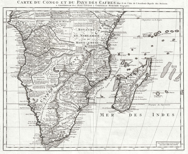
Carte du Congo et du Pays des Cafres. Par G. de l'Isle de l'Academie Royale des Sciences. A Amsterdam, Chez Jean Covens et Corneille Mortier, Geographes.
c. 1739 (undated) 19.5 x 24 in (49.53 x 60.96 cm)
c. 1739 (undated) 19.5 x 24 in (49.53 x 60.96 cm)
Description
An extraordinary example of Covens and Mortier's c. 1730 issue of De L'Isle's important c. 1707 map of Africa south of the Equator. Depicts the southern Africa in stunning detail with numerous notations an comments regarding the people, geography, and wildlife of the region. De L'lsle was very a cautious and scientific cartographer, basing his maps on the first hand reports from sailors, merchants and missionaries that, at the time, were flowing into Paris at an unprecedented rate. This map offers significant detail throughout the interior naming numerous tribal areas and kingdoms including the Jaga, the Kongo, the Angola, the Kingdom of Numeamaie or Mono-Emugi, Monomotapa, Gingiro, and others. Shows the Portuguese trading colonies of Sena and Tete (Santiago) on the Zambezi River. Also near the Zambezi, 'La Victoire Couvent de Dominicains' is worth of mention. Also notes the predominantly Arab island kingdoms of Pemba and Zanzibar. Identifies the Dutch colonies near the Cape of Good Hope, including 'Fort Hollandois' (Cape Town).
Near the Equator, De L'Isle identifies an enormous lake almost exactly in the modern location and form of Lake Victoria. He notes that this is a 'Grand Lac place sur le raport des Negres.' What is remarkable about this is not the appearance of a lake in this region, one of the two Ptolemaic sources of the Nile appeared on maps of this area for hundreds of years, but rather that it seems to be based on actual evidence and it is not connected to any of the great African river systems. It seems highly likely that this is one of the first clear references to Lake Victoria to appear on a map.
The condition of this map bears special mention. We have rarely encountered an antique map from any era in such outstanding condition. The condition of the paper, the quality of the engraving, and the overall state of preservation of this map is beyond compare. If you are considering adding an example of this map to your collection, this is the one you want.
CartographerS
Covens and Mortier (1721 - c. 1862) was an Amsterdam publishing firm, the successor to the extensive publishing empire built by Pierre Mortier (1661 - 1711). Covens and Mortier maps are often criticized as derivative - but this is not fully the case. Pierre Mortier lived in Paris from 1681 to 1685. There he established close relationships the the greatest French cartographers of the era, including De L'Isle and D'Anville. His business model was based upon leveraging Dutch printing technology and sophistication to co-publish state of the art French cartography. Upon Mortier's death in 1711 his firm was taken over by his son, Cornelius Mortier (1699 - 1783). Cornelius married the sister of Johannes Covens (1697 - 1774) in 1721 and, partnering with his brother in law, established the Covens and Mortier firm. Under the Covens and Mortier imprint, Cornelius and Johannes continued in Pierre's model of publishing the most up-to-date French works with permission. They quickly became one of the largest and most prolific Dutch publishing concerns of the 18th century. The firm and its successors published thousands of maps over a 120 year period from 1721 to the mid-1800s. During their long lifespan the Covens and Mortier firm published as Covens and Mortier (1721 - 1778), J. Covens and Son (1778 - 94) and Mortier, Covens and Son (1794 - c. 1862). More by this mapmaker...
The De L'Isle family (fl. c. 1700 - c. 1760) (also written Delisle) were, in composite, a mapmaking tour de force who redefined early 18th century European cartography. Claude De L'Isle (1644 -1720), the family patriarch, was Paris based a historian and geographer under Nicholas Sanson. De L'Isle and his sons were proponents of the school of "positive geography" and were definitive figures, defining the heights of the Golden Age of French Cartography. Of his twelve sons, four, Guillaume (1675 - 1726), Simon Claude (1675 - 1726), Joseph Nicholas (1688 - 1768) and Louis (1720 - 1745), made a significant contributions to cartography. Without a doubt Guillaume was the most remarkable member of the family. It is said that Guillaume's skill as a cartographer was so prodigious that he drew his first map at just nine years of age. He was tutored by J. D. Cassini in astronomy, science, mathematics and cartography. By applying these diverse disciplines to the vast stores of information provided by 18th century navigators, Guillaume created the technique that came to be known as "scientific cartography", essentially an extension of Sanson's "positive geography". This revolutionary approach transformed the field of cartography and created a more accurate picture of the world. Among Guillaume's many firsts are the first naming of Texas, the first correct map of the Mississippi, the final rejection of the insular California fallacy, and the first identification of the correct longitudes of America. Stylistically De L'Isle also initiated important changes to the medium, eschewing the flamboyant Dutch style of the previous century in favor of a highly detailed yet still decorative approach that yielded map both beautiful and informative. Guillaume was elected to the French Academie Royale des Sciences at 27. Later, in 1718, he was also appointed "Premier Geographe du Roi", an office created especially for him. De L'Isle personally financed the publication of most of his maps, hoping to make heavy royalties on their sales. Unfortunately he met an untimely death in 1728, leaving considerable debt and an impoverished child and widow. De L'Isle's publishing firm was taken over by his assistant, Phillipe Buache who became, posthumously, his son in law. The other De L'Isle brothers, Joseph Nicholas and Louis De L'Isle, were employed in the Service of Peter the Great of Russia as astronomers and surveyors. They are responsible for cataloguing and compiling the data obtained from Russian expeditions in the Pacific and along the northwest coast of America, including the seminal explorations of Vitus Bering and Aleksei Chirikov. The De L'Isles, like their rivals the Vaugondys , must be considered speculative geographers. Speculative geography was a genre of mapmaking that evolved in Europe, particularly Paris, in the middle to late 18th century. Cartographers in this genre would fill in unknown areas on their maps with speculations based upon their vast knowledge of cartography, personal geographical theories, and often dubious primary source material gathered by explorers and navigators. This approach, which attempted to use the known to validate the unknown, naturally engendered many rivalries. The era of speculatively cartography effectively ended with the late 18th century explorations of Captain Cook, Jean Francois de Galaup de La Perouse, and George Vancouver. Learn More...
Source
Covens, J. & Mortier, C., Atlas nouveau, contenant toutes les parties su Monde, ou sont exactement remarquees les empires, monarchies, royaumes, etats, republiques, &c. Par Guillaume de l'Isle, c. 1830 editon.
Condition
Incredible. A nearly flawless example. We have rarely seen any 18th century maps in such phenomenal condition. Wide clean margins. White clean paper. Dark heavy impression. Original centerfold - as issued. If you plan to add an example of this map to your collection, then this is the one you want.
References
Rumsey 4638.091 (1742 edition). Tooley, R. V., Collector's Guide to Maps of the African Continent and Southern Africa, p. 72.