
1942 Fort Pro-Axis / Vichy Pictorial Propaganda Wall Map of Africa

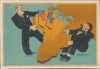
[Africa Tug of War].
Pro-Vichy Propaganda Response to Operation Torch.
- Digital Map Information
- Suitable for large format printing
- Full resolution TIFF file
- ICC color profile embedded
- Delivered instantly via download link
Pro-Vichy Propaganda Response to Operation Torch.
This is a c. 1942 Jean Fort pictorial propaganda poster that presents Africa as the object of an Anglo-American land grab. It was produced by the Office de Répartition de l'Affichage (ORAFF), the branch of the Vichy government tasked with propaganda work and particularly attention-grabbing posters such as this. Caricatures of Roosevelt and Churchill clutch opposite sides of the continent, turning Allied cooperation into a struggle for imperial possession. The image appealed to French resentment over threats to the colonial empire, an argument given urgency by the Allied landings in French North Africa (Operation Torch) in November 1942.A Closer Look
Africa dominates the composition as a solid ochre slab, with no boundaries, settlements, or place-names. American and British flags planted in northwestern Africa supply the only territorial claims. Franklin D. Roosevelt (1882 - 1945), recognizable by his spectacles and exaggerated profile, stands in the Atlantic at left, grasping western and northern Africa. Winston Churchill (1874 - 1965) pulls from the opposite side, wearing a helmet and an enormous spotted bow tie, with a smoking cigar projecting from his mouth. The figures' strained postures make their alliance look competitive and acquisitive. The image also directs attention away from the Axis powers. No German or Italian leader appears, and nothing acknowledges their territorial ambitions or military presence in Africa. The selective geography makes Britain and the United States the sole visible aggressors, allowing an anti-Allied message to operate without explicitly endorsing Germany.The poster's accusation closely accords with Vichy's response to the November 1942 landings (see below). In his November 8 message to Roosevelt, the head of the Vichy government characterized the American operation as aggression against French North Africa and ordered resistance. That evening, the American chargé d'affaires reported that Vichy had declared diplomatic relations severed because American troops had entered French territory.
Operation Torch
Launched on November 8, 1942, Operation Torch was the Allied amphibious invasion of Vichy-controlled French North Africa, marking the first major joint Anglo-American ground offensive in the European-Mediterranean theater of World War II. Commanded by General Dwight D. Eisenhower, the operation landed roughly 107,000 troops across three key objectives in Morocco and Algeria—Casablanca, Oran, and Algiers—to establish a western front in North Africa. Although Allied leaders hoped Vichy French garrisons would stand down, sharp resistance erupted in several sectors until a controversial political deal with Vichy Admiral François Darlan secured a ceasefire and brought French colonial forces onto the Allied side. By rapidly securing these ports and pushing eastward toward Tunisia, Allied forces caught Field Marshal Erwin Rommel's German-Italian Afrika Korps in a massive strategic pincer, squeezing Axis troops between Eisenhower's forces and General Bernard Montgomery's British Eighth Army, which was advancing westward following its victory at El Alamein.Within the wider context of the war, Operation Torch was the product of a critical strategic compromise between the United States and Great Britain over how to defeat Nazi Germany. American planners initially favored an immediate cross-Channel invasion of occupied France to relieve the immense pressure on the Soviet Union, which was locked in a desperate struggle at Stalingrad. However, British Prime Minister Winston Churchill argued that the Allies lacked the readiness for a direct assault on Fortress Europe and persuaded President Franklin D. Roosevelt to pursue a peripheral strategy aimed at Axis vulnerabilities in the Mediterranean. While delaying a Western European front until 1944 strained relations with Joseph Stalin, Torch proved indispensable to the Allied war effort: it culminated in the Axis surrender in Tunisia in May 1943, restored Allied naval control of the Mediterranean, opened the path for the invasions of Sicily and mainland Italy, and provided the vital logistical and coalition-command experience required for the D-Day landings in Normandy.
Publication History and Census
The poster is signed at upper left by Jean Fort, an artist about whom nothing is known. It was printed by Bedos et Cie in Paris for ORAFF, the Office de répartition de l'affichage, the arm of the Nazi-collaborationist Vichy government tasked with producing and posting large works such as this in public places. The sheet is undated but can be presumed to closely follow the Operation Torch landings. This work is rare, held only by the Library of Congress and the Bibliothèque nationale de France, with a limited market history.Cartographers
Bedos et Cie (fl. c. 1937 - 1976) was a French printing and publishing house based in Paris, producing lithographic posters, advertising material, and map-based propaganda during the 20th century. The firm advertised as printers and lithographers in 1937 and is documented at 14 avenue Félix-Faure in the 15th arrondissement. Its cartographic work included printing Victoria: La croisade contre le bolchevisme (1942), a propaganda poster incorporating a map of Europe that depicted German territorial advances and projected expansion eastward. Its wartime output also included material for the Secours National and the Vichy government's publicity campaigns. After the war, Bedos printed commercial and entertainment advertising, including circus posters for Pinder and the Bouglione brothers. The firm's production employed both color lithography and offset printing, and institutional records document work bearing its imprint as late as 1976. Further Details...
Office de Répartition de l'Affichage (November 1941 - c. August 1944), generally abbreviated ORAFF or ORAF, was a Paris-based organization established by the German occupation authorities in November 1941 to regulate poster distribution and public display in France. Distinct from the Propaganda-Abteilung Frankreich, but operating under its oversight, the office formed part of the machinery through which the occupiers controlled French visual publicity. Its relevance to cartographic history lies principally in the circulation and authorization of propaganda posters incorporating maps, rather than in surveying or original geographical compilation. The office issued numbered visas authorizing public display; consequently, an ORAFF inscription can indicate regulatory approval rather than authorship, printing, or sole responsibility for publication. Its remit extended beyond overtly political material to commercial and entertainment posters, while its marks also appeared on publications of Vichy's information services. Propaganda associated with the office promoted French labor in Germany, attacked the Resistance, and represented the Soviet Union and communism as threats to France and Europe. Cartographic imagery was particularly useful to these campaigns: posters such as Voilà ce que le bolchevisme apporterait à l'Europe (1943) and Après l'Algérie et la Corse, demain ce sera la France (1944) transformed European and Mediterranean geography into threatening images intended to discredit the Allies and legitimize continued German occupation. Further Details...
Condition
Good. Mounted on linen. Closed tears. Very small areas of loss. Infill to upper-right corner of border.
References
Bibliothèque nationale de France, FRBNF39837748. Library of Congress, War map: pictorial and propaganda map collection 1900 - 1950, folder 91. United States Department of State, Foreign Relations of the United States, Diplomatic Papers, 1942, Europe, vol. II, documents 203 and 428.