
1827 Heinrich Berghaus / Brose Separate-issue Map of Africa

This item has been sold.
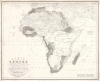
KARTE von AFRIKA Nach den neuesten Entdeckungen und Ansichten, mit besonderer Rücksicht auf Karl Ritters Erdkunde.Ein kritischer Versuch, entworfen und bearbeitet im Jahre 1824 von Heinrich Berghaus.
'The most beautiful terrain ever engraved' - Hoffmann
- Digital Map Information
- Suitable for large format printing
- File Size: 38.76 MB
- File Type: ZIP / TIFF
- ICC color profile embedded
- Delivered instantly via download link
'The most beautiful terrain ever engraved' - Hoffmann
This is Heinrich Berghaus' important 1826 separate-issue map of Africa. As with all of Berghaus' separate issue works, it is scarce today due to small print runs, but was influential in its time for establishing new conventions in the standardized rendering of terrain, one of the major challenges of early 19th-century cartography. It is the great cartographer's earliest known solo work, following only his 1825 contributions to Reymann's topographische Special-Karte von Deutschland. As a whole, this map is the most comprehensive summary of African geography known to Europeans in the early 19th century.A Closer Look
Coverage embraces the continent of Africa and the surrounding seas in meticulous detail, with a special focus on terrain and topography. Throughout, the cartographer draws on the most up-to-date explorations and discoveries, with some reports having become available only a year prior (1825; see sources section below). The routes of known explorers are included and labeled, as are continent-spanning caravan routes little known to Europeans - note the expansive network of trade routes radiating from Timbuktu.Challenges of Rendering Terrain
This map is most significant for pioneering the systematic rendering of topography and terrain - a problem of early 19th-century cartography, which demanded more precision than the pictorial mountains of the 18th century. Quoting Jan Smits in Petermann's Maps,One of the most important problems in cartography in the nineteenth century was how to solve the problem of depicting elevations. This ranged from shading [Schummerungstechnik], hachuring and fine hachuring [Schraffen und Böschungsschraffen] and isohypses or contour-lines [Höhenlinien] in the nineteenth century to isohypses with layer zones [Höhenlinien mit farbig angelegten Flächen], and later with coloured elevation bands without isohypses but with shading in the early twentieth century.... Berghaus especially strove to perfect techniques for representing elevations, for he thought it important that cartographers and engravers learn to depict mountains in the smaller and smallest scales and to use hachuring sparingly or only when appropriate. He complained:This map, and a smaller map of Spain, where, in effect, Berghaus's studies in new and novel techniques for illustrating terrain.Few have made use of the geometric basis for the graphic depiction of the unevenness of the terrain; people have neglected to measure elevations and consequently to depict contours or lines of equal elevation, satisfying themselves with the approximate gauging of the surface angle. This has led to terrain representations that cannot lay claim to hypsometric or orographic accuracy, despite all their apparent beauty.
Contemporaneous Praise
The map received glowing contemporary praise by Karl Friedrich von Hoffmann (1779 - 1846), published in the German scientific journal Geographische Zeitung der Hertha (1826, page 13), often associated with work of geographer Franz Ritter (our translation):To express praise - however well deserved - for the work of a dear friend seems, according to the usual course of human affairs, all the more delicate the greater that praise must be. Nevertheless, let it be permitted to me to call attention in Hertha to such a remarkable manifestation of illustrative geography, without touching upon the scientific content of the work, and only to remark upon the beauty of its copper engraving. Professor Berghaus himself, as readers of Hertha will recall from the first issue of the fifth volume, has already begun to explain the principles of his design and to state the reasons which led him to treat the map in precisely this way and not otherwise.
As to the beauty of the map, I can say, according to my conviction and after comparison with the most elegant works of France, of the Austrian general staff, of England, and others, nothing less than this: the terrain on this map is the most beautiful ever engraved and made available to the public, standing infinitely above all works previously revered as masterpieces and the highest achievements of topographical copper engraving. Whoever wishes to compare - carefully and rigorously - the best and finest works of this kind, such as those by v. Schussfelder, Baptist Seiz, Tardieu, Kolbe, Bimbe, and Bach, will determine whether this judgment, that Mr. Brose surpasses all as the foremost engraver of terrain, is too favorable to one or too unfair to the others - and whether this map is indeed the most beautiful produced thus far.
Sources
Berghaus is meticulous in delineating his sources (our translation) directly on the map, both as a text block in the bottom right and as annotations directly on the map,Since knowledge of Africa advances with each passing year, it is important to establish the exact moment to which a description or depiction of this part of the world applies. The present map corresponds to the year 1824; it is distinguished by the reports of Bowdich on the Congo, etc., and by the journeys of the British explorers into the Sudan. These important contributions to our understanding of this difficult and little-known continent—as they were known at the beginning of 1824—have been used in the present representation.
The source region of the Niger is based on the precise observations of Mungo Park, taking into account the corrections of Walckenaer; the reports of Mollien were rejected, with reference to Ritter's Geography, Book I, although they have since been confirmed by Laing (1825). Both accounts of the Joliba source are indicated. Other, individual corrections by Rüppel, Westphal, Parthey, Beaufort, Dussault, Hay, Massieu de Clerval, etc., became known too late to be incorporated into the already advanced engraving of the map.
The coastline of the Mediterranean is after Gauttier. The reports of Smee and Hardy (1811) concerning the east coast and the river mouths there have not been included, as they appear to require further confirmation. New corrections will be communicated by supplementary sheets (Kartons). See in this respect the preliminary work of Smyth's map of the Sudan (1825) in Hertha, vol. III. For details on the preparation of this map, see Hertha, vol. V.
Publication History and Census
This map was compiled by Heinrich Berghaus to supplement Carl Ritter's Erdkunde, one of the largest and most influential works of geography ever published. It was engraved by Henirich Brose and published by J. G. Cotta in Stuttgart. An advertisement at the bottom center, just below the border, notes that the map was for sale at the shops of Simon Schropp in Berlin, Artaria in Vienna and Mannheim, and Picquet in Paris.The map is rare. We see examples at Harvard, the Württembergische Landesbibliothek, and the Bibliothèque Nationale de France. No market history.
Cartographers
Heinrich Karl Wilhelm Berghaus (May 3, 1797 - February 17, 1884) was a German (Prussian) geographer, linguist, and ethnologist who founded the Potsdam Geographische Kunstschule. He was born in Kleve, Germany, and, as a young man, trained as a surveyor. He put his training to work in 1811, working in the French Department of Lippe as a bridge and road engineer. When the Kingdom of Westphalia dissolved in 1813, he volunteered for the Prussian army administration, traveling with General Bogislav Friedrich Emanuel von Tauentzien (1760 - 1824) as far as Brittany. In 1816, he joined the staff of the Prussian trigonometrical survey, conducting surveys throughout the nation. Among his many accomplishments, Berghaus is credited with inventing the 'thematic atlas' in 1845. In addition to his own work, he trained some of the most important German geographers and cartographers of the late 19th century, including August Heinrich Petermann (1822 - 1878) and his nephew Hermann Berghaus (1828 - 1890). The elder Berghaus also was a friend and associate of the naturalist Alexander von Humboldt (1769 - 1859), producing some of the maps in his publications. In 1837, he inherited rights to Daniel Gottlob Reymann's (1759 - 1837) monumental Geographischer Specialatlas von Deutschland. Berghaus is best known for his own influential and wide-ranging atlases, namely Atlas von Asien, published between 1833 and 1837, and Berghaus' Physikalischer Atlas, published in multiple editions in the 1830s - 1840s. Although Atlas von Asien was a commercial failure, it was regarded as a work of supreme quality, boosting the reputation of the publisher Justus Perthes and setting up their next collaboration, Berghaus' Physikalischer Atlas, for success. In addition to his geographical work, Berghaus was also an accomplished linguist and ethnologist and published an important 1851 article on American Indian language and ethnology (Geographisches Jahrbuch, 1851). Further Details...
Karl Heinrich Brose (July 16, 1783 - October 18, 1861) was a German cartographic engraver and topographer active in the first half of the 19th century. Brose is considered one of the pioneers of modern topographical engraving. He was born in Berlin and, proving apt at drawing, apprenticed as a geographical engraver under his uncle Karl Jäck, who worked with Sotzmann and Schrötter, among others. He was working on Schrötter's topographical survey of Prussia when Napoleon invaded in 1803. Sometime between that time and 1807, he moved to Paris, where he engraved maps for the Dépôt de la Guerre. From 1813, he served in the military, seeing action in Grossbeeren and Leipzig. After the Napoleonic Wars (1803 - 1815), he returned to map engraving in Germany. Among his more famous works is Heinrich Berghaus's (1797 - 1884) 1826 map of Africa, which, apart from its intrinsic content, remains to this day an unsurpassed sheet of geographical copperplate engraving and laid the foundation for most future topographical engraving. He is likely related to another German engraver, Wilhelm Brose (17xx - 18xx), who engraved fror Perthes, Berghaus, and Flemming, although this has not been confirmed. Further Details...
J. G. Cotta (1659 - 1889) was a German publishing house active from the 17th through the 19th centuries. The firm was founded in 1659 when Johann Georg Cotta (1631 - 1692) married the widow of the Tübingen university bookseller, Philipp Braun, and took over the management of his business, rebranding it in his own name. The firm passed in 1792 to Johann Georg Cotta II (1663 - 1712) and then to his son, Johann Georg Cotta III (1693 - 1770). The eldest son of Johann Georg Cotta III, Christoph Friedrich Cotta III (1730 - 1807), relocated the firm to Stuttgart when he acquired a lucrative contract with the royal court. Nonetheless, the firm languished. It was Christoph's son, Johann Friedrich Cotta von Cottendorf (JFC; April 27, 1764 - December 29, 1832), who revived the firm's fortune. In 1787, after studying mathematics, law, and natural sciences at the University of Tübingen, he took over the family firm. JFC moved the firm into lucrative magazine publishing and became closely associated with the publishing interests of the German playwright Friedrich Schiller (1759 - 1805) and, even more significantly, Johann Wolfgang von Goethe (1749 - 1832), a central figure in German literature and a widely influential German poet, novelist, playwright, and scientist. The firm became immensely successful, and JFC went on to a successful career in politics, while never neglecting the publishing business. He passed the firm to his son, Freiherr Cotta von Cottendorf (1796 - 1863), and he to his son, Karl von Cotta ( - 1888). Karl was the last Cotta to control the business. In 1889, after his death, it was acquired by Adolf and Paul Kroner. We use this date as the terminal date of the Cotta family firm. The business, in a more modern corporate form, still publishes under the imprint Klett-Cotta. Its contemporary offerings include German-to-Elvish dictionaries based on J.R.R. Tolkien's Lord of the Rings. Further Details...
Condition
Good. Some surface soiling and scuffs. A few inor edge tears.
References
OCLC 646115029. Bibliothèque Nationale de France, FRBNF40674274. Smits, J., Peterman's Maps: Cartobibliography of the Maps in Petermanns Geographische Mitteilungen, 1855-1945, #55.