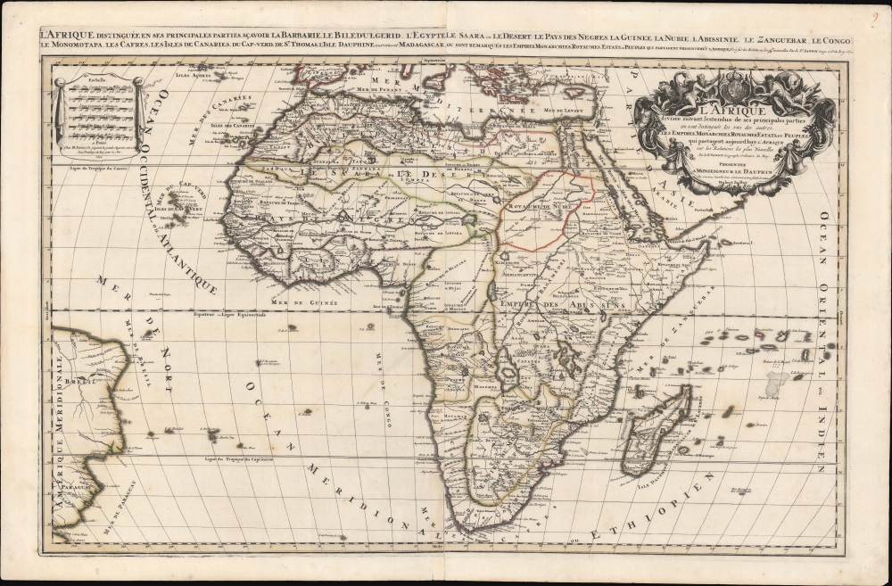
1692 Jaillot / Sanson Map of Africa
Afrique-jaillot-1692$2,500.00


Title
L'Afrique distinguée en ses principales parties, sçavoir La Barbarie, Le Biledulgerid, L'Egypte, Le Saara ou le Desert, Le Pays des Negres, La Guinee, La Nubie, L Abissinie, Le Zanguebar, Le Congo, Le Monomotapa, Les Cafres, Les Iles de Canarie, du Cap-Verd, de St.Thomas, L'Isle Dauphine, autrement Madagascar, ou sont remarqués les Empires, Monarchies, Royaumes, Estats, et peuples qui partagent presentement L'Afrique.Tiré sur les Relations les plus nouvelles. Par le Sr. Sanson, Geographe ordre. du Roy.
1692 (dated) 25 x 38 in (63.5 x 96.52 cm) 1 : 20181800
1692 (dated) 25 x 38 in (63.5 x 96.52 cm) 1 : 20181800
Description
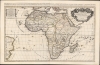
This is a spectacular 1692 first Pierre Mortier edition of Alexis-Hubert Jaillot and Guillaume Sanson's large-format map of Africa - one of the largest and most beautiful atlas maps of the continent to appear in the 17th century, here in a striking old color example.
Another imaginary island, 'S. Helena Nova' appears in the Atlantic, due east of St. Helena. Little is known of the island's origins, but it was reported by navigators in the first quarter of the 17th century. Such an island would be valuable for ships seeking shelter after passing the Cape of Good Hope towards Europe. In 1657, the Maria, en route from St. Helena, searched for it some 14 days before giving up. It nonetheless remained on maps for nearly 100 years afterwards.
A Closer Look
This continental map embraces all of Africa as well as adjacent parts of the Mediterranean, South America, and the Indian Ocean. At the time, while the general outline of Africa was known, the interior remained a mystery. In terms of innovation, this map is most significant for it correction of the location of the Zambezi River, correctly placing it north of Sofala.The Ptolemaic Lakes
Like most maps of the 17th century, the maps of the Sanson-Du Val lineage present the two great lakes of Zaire / Zembre and Zaflan as the sources of the River Nile, a geographical assumption reaching back to Ptolemy. Here the White Nile (Nubia R.) flows from the west, while the Blue Nile extends far south, connecting with Zaire and Zaflan, which themselves have been moved north to accommodate the shifted Zambezi. Another new river, the 'Zambere' has been introduced to the south of Sofala.Flacourt's Madagascar
The geography of Madagascar and its surrounding islands also places this map in the lineage of maps following Sanson and other French cartographers of the second part of the 17th century. Fort Dauphin is marked on the southeast coast of Madagascar. This settlement first shows up in Etienne de Flacourt's map of Madagascar, and was reproduced in the maps of Sanson and Du Val. Jaillot's maps would also reproduce this, but by the end of the 17th century it was also appearing on Dutch maps. A bay in the west coast of Madagascar, Ance de Mansiatre, is presented distinctively here. This too traces back to Flacourt's map and shows a clear lineage from French cartographic sources - although by the time this map was produced other Dutch cartographers adopted the French model. Between Madagascar and the mainland, the Baixos de Judia appears as an island, extending north to south. These shallows appeared on Blaeu's map, and likewise the works of Jaillot and Coronelli. Du Val's 1678 map presents the shallows as an island, as does the Danckerts. The Nolin and Coronelli maps both show the shallows as a triangular area, but not as an island. For this feature, De Fer marks an island in a triangular shallows.Imaginary Islands
South of the island of Apollonia (Isle de Bourbon) is an imaginary island named 'Dos Romeiros dos Castillianos' (from the Portuguese, the Pilgrim's islands of the Spanish). Jaillot's map presents this island as an archipelago approximately ten degrees to the east, a trait shared on maps by Visscher and de Ram. Many Africa maps do not show the islands at all - not so much because the archipelago is imaginary, as because they do not reach far enough to the east.Another imaginary island, 'S. Helena Nova' appears in the Atlantic, due east of St. Helena. Little is known of the island's origins, but it was reported by navigators in the first quarter of the 17th century. Such an island would be valuable for ships seeking shelter after passing the Cape of Good Hope towards Europe. In 1657, the Maria, en route from St. Helena, searched for it some 14 days before giving up. It nonetheless remained on maps for nearly 100 years afterwards.
First Pierre Mortier Edition
Although his name appears nowhere on this map, this is in fact the first edition produced in Amsterdam by Pierre Mortier. It is from a break-away edition of Jalliot's Atlas Nouveau, produced in Amsterdam by Pierre Mortier and Marc Huguetan. The partners chose to keep their names off the maps, as well as the atlas as a whole, attributing it fully to Sanson and Jalliot, likely to more closely associate it with the famous French mapmakers. In later editions, Mortier's name is added to both the upper title and the cartouche.Publication History and Census
The map was originally published in 1674 from a plate engraved by Robert Cordier. The present 1692 edition is a new plate fully re-engraved plate in Amsterdam by Pierre Mortier to a much higher standard than the French editions. The present edition is derived from the 1685 2nd French state. Well represented institutionally but scarce on the market in such fine original-color condition.CartographerS
Alexis-Hubert Jaillot (c. 1632 - 1712) followed Nicholas Sanson (1600 - 1667) and his descendants in ushering in the great age of French Cartography in the late 17th and 18th century. The publishing center of the cartographic world gradually transitioned from Amsterdam to Paris following the disastrous inferno that destroyed the preeminent Blaeu firm in 1672. Hubert Jaillot was born in Franche-Comte and trained as a sculptor. When he married the daughter of the Enlumineur de la Reine, Nicholas I Berey (1610 - 1665), he found himself positioned to inherit a lucrative map and print publishing firm. When Nicholas Sanson, the premier French cartographer of the day, died, Jaillot negotiated with his heirs, particularly Guillaume Sanson (1633 - 1703), to republish much of Sanson's work. Though not a cartographer himself, Jaillot's access to the Sanson plates enabled him to publish numerous maps and atlases with only slight modifications and updates to the plates. As a sculptor and an artist, Jaillot's maps were particularly admired for their elaborate and meaningful allegorical cartouches and other decorative elements. Jaillot used his allegorical cartouche work to extol the virtues of the Sun King Louis IV, and his military and political triumphs. These earned him the patronage of the French crown who used his maps in the tutoring of the young Dauphin. In 1686, he was awarded the title of Geographe du Roi, bearing with it significant prestige and the yearly stipend of 600 Livres. Jaillot was one of the last French map makers to acquire this title. Louis XV, after taking the throne, replaced the position with the more prestigious and singular title of Premier Geographe du Roi. Jaillot died in Paris in 1712. His most important work was his 1693 Le Neptune Francois. Jalliot was succeeded by his son, Bernard-Jean-Hyacinthe Jaillot (1673 - 1739), grandson, Bernard-Antoine Jaillot (???? – 1749), and the latter's brother-in-law, Jean Baptiste-Michel Renou de Chauvigné-Jaillot (1710 - 1780). More by this mapmaker...
Guillaume Sanson (1633 - 1703) was a French cartographer active in the latter part of the 17th century. He is the son of the legendary cartographer Nicolas Sanson (1600 - 1667), and, along with his brother Adrien Sanson (1639 - 1718), took over the family firm on his father's death. Like his father, Guillaume Louis XIV granted him the official title, Geographe Ordinaire du Roy. Much of his work after 1671 was published in collaboration with Alexis-Hubert Jaillot (c. 1632 - 1712). Although the continued to published new maps, particularly Guillaume Sanson, the firm began to lose prestige and market share. In 1692, the brothers sold their geographical archive to their nephew Pierre-Moulart Sanson (1670 - 1730), who published a map catalog in 1696 and reissued the Sanson atlas. After Pierre-Moulart's death, many of the surviving map plates were acquired by Gilles Robert de Vaugondy, setting the stage for another French cartographic dynasty. Learn More...
Pierre Mortier (January 26, 1661 - February 18, 1711) or Pieter Mortier was a cartographer, engraver, and print seller active in Amsterdam during the later 17th and early 18th centuries. Mortier, then known as Pieter, was born in Leiden. He relocated to Paris from 1681 to 1685, adopting the French name Pierre, which he retained throughout his career. While in France, he developed deep French connections by bringing sophisticated Dutch printing technology and experience to nascent French map publishers such as Guillaume De L'Isle (1675 - 1726), Alexis-Hubert Jaillot (c. 1632 - 1712), and Nicholas de Fer (1646 - 1720). Consequently, much of Mortier's business was built upon issuing embellished high quality editions of contemporary French maps - generally with the permissions of their original authors. In the greater context of global cartography, this was a significant advantage as most Dutch map publishes had, at this point, fallen into the miasma of reprinting their own outdated works. By contrast, the cartographers of France were producing the most accurate and up to date charts anywhere. Mortier's cartographic work culminated in the magnificent nautical atlas, Le Neptune Francois. He was awarded the Privilege, an early form of copyright, in 1690. Upon Pierre's death in 1711 this business was inherited by his widow. In 1721, his son Cornelius Mortier took over the day to day operation of the firm. Cornelius partnered with his brother-in-law Jean Covens to form one of history's great cartographic partnerships - Covens and Mortier - which continued to publish maps and atlases until about 1866. Learn More...
Condition
Very good. A few very minor verso stabilizations. Old color.
References
Norwich, O. I., Norwich's Maps of Africa: An Illustrated and Annotated Cartobibliography, #46. Betz, R., The Mapping of Africa A Cartobibliography of Printed Maps of the African Continent to 1700, #156. OCLC 961837727.