This item has been sold, but you can get on the Waitlist to be notified if another example becomes available, or purchase a digital scan.
1778 Zatta / Mitchell Map of Louisiana, Mississippi, Alabama, Georgia, Florida
Alabama-zatta-1778$300.00

Title
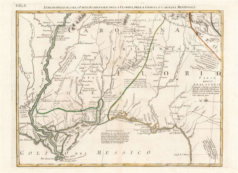
Luigiana Inglese, colla Parte Occidentale della Florida, della Giorgia, e Carolina Meridonale.
1778 (undated) 12.75 x 16.5 in (32.385 x 41.91 cm) 1 : 21000000
1778 (undated) 12.75 x 16.5 in (32.385 x 41.91 cm) 1 : 21000000
Description
This is an attractive and fascinating 1778 Antonio Zatta map of the Gulf Coast from Louisiana to Florida, encompassing the region inclusive of modern-day Mississippi, Alabama and Georgia. The geography is drawn from John Mitchell's foundational 1755 A map of the British and French dominions in North America, the most important map of North America published in the 18th century. It remained so authoritative that it was used to draft the borders of the United States following Independence, and consulted for border disputes as recently as the 1980s. The present sheet hails from Zatta's Italian edition of the Mitchell, which faithfully copied the original in translation.
Native American Interest
The map's detail is superb, particularly for the Alabama River Valley. The map includes considerable detail of the region's Native American territories, the Chickasaw, Choctaw, and Creek among them. The map includes key trading routes, forts, and crossed swords indicating specific battles from Queen Anne's War, including the Apalachee Massacre. These were the sites of English colonial raids against the Apalachee and their Spanish allies, including the Battle of Ayubale, the only instance of large-scale resistance to the English attacks.Publication History and Census
This map was first engraved for Antonio Zatta's Atlante Novissimo which included his translation of Mitchell's map in twenty of the four-volume atlas's 218 maps. There are half a dozen examples of this separate sheet listed in institutional collections; the atlas is well represented in institutional collections.CartographerS
Antonio Zatta (1775 - April 2, 1797) was the most prominent Italian map publisher of the late 18th and early 19th century. His firm, based in Venice, produced maps that mark an important transition from 18th to 19th century cartographic styles. He updates and redefines the traditional title cartouche by replacing the mythic elements common to the 17th and 18th century with more representative images. His maps also strive to keep many 18th century details, such as figural depictions on the map itself, while striving for the accuracy that a 19th century clientele demanded. His most important work is the four volume Atlante novissima published from 1775 to 1789. More by this mapmaker...
John Mitchell (April 13, 1711 – February 29, 1768) was and British-American mapmaker of great significance. He is known for one and only one map, the 'Mitchell Map', considered the most important map in 18th century American history. Mitchell was born in Lancaster County, Virginia, the son of a prosperous planter and merchant. Like many of his social peers, he was educated in Europe, at Scotland at Edinburgh University, where he studied medicine. Mitchell practiced medicine in Virginia for a short time prior to the French and Indian War. He was elected to the original American Philosophical Society in 1744. In 1745 Mitchell argued that a series of epidemics occurring in Virginia were due to unsanitary troop ships from Britain - at the time a revolutionary idea. He relocated to London in 1746 - presumably for the agreeable climate. Mitchell never practiced medicine in London, but was known to be an avid botanist, and was considered an exotic plant expert in London society circles. He was elected as a fellow of the Royal Society in November 1748, his candidature citation describing him as
A Gentleman of great merit and Learning, who Some time Since communicated to the Royal Society a very curious dissertation concerning the Colour of the skin in Negroes, and who from his long residence in Virginea, and from his great application to the Study of Natural history, especially Botany, is very well acquainted with the vegetable productions of North America, being desirous of being admitted a fellow of the Royal Society, is recommended by us from our personal knowledge of him as highly deserving the Honour he desires, as we believe he will be (if chosen) a usefull and valuable member of our Body.As an educated American adopted into British high society, Mitchell became the de facto expert on all matters North American. In 1749, during a time of ever-increasing political tensions between British and French interests in America, Lord Halifax contracted Mitchell to produce a large and detailed map of British and French dominions in America. While embracing the most advanced geographical data, Mitchell also advocated pro-British interpretation of political boundaries. The resulting map was thus geographically unimpeachable and reframed the cartographic perspective from French to British terms. The map proved significant and was used in most subsequent treaties. Michell issued 3 editions in his lifetime. He died in London in 1768. Learn More...
Source
Zatta, A., Atlante Novissimo, illustrato ed accresciuto sulle osservazioni, e scoperte fatte dai più celebri e più recenti geografi, (Venice), 1779.
Condition
Excellent. A marginal printers' crease; else fine with original outline color.
References
OCLC 48797306. Rumsey 5007.012.