
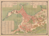
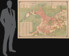
1887 Tanzim Arabic / French Large Scale Map of Alexandria, Egypt

This item has been sold.
Direction Générale du Tanzim Plan de la Ville D'Alexandrie Dressé à l'Inspection de L'Ouest. / إدارة عموم التنظيم. خريطة مدينة الإسكندرية
Best map of Alexandria of the 19th century.
- Digital Map Information
- Suitable for large format printing
- Full resolution TIFF file
- ICC color profile embedded
- Delivered instantly via download link
Best map of Alexandria of the 19th century.
This is a monumental 1887 Arabic and French administrative plan of Alexandria, prepared by the Egyptian Tanzim, the largest and most important map of Alexandria printed in the 19th century. The map records the city's streets, institutions, and government property in the early years of British occupation. Its extensive bilingual indexes turn a building-level survey into a working directory of the city, distinguishing private buildings from state establishments, religious institutions, and baths. The inventory of government property is particularly revealing, identifying destroyed fortifications and buildings occupied by British soldiers. The map brings together Alexandria's commercial infrastructure, religious communities, and altered military geography in a single official document.A Closer Look
The plan embraces both harbors, the Ras el-Tin peninsula, and the densely built city extending south to Karmous and the Mahmoudieh Canal. Coverage reaches east to the Rosetta Gate, the coastal hospital and quarantine establishment, and the railway toward Ramleh; Lake Mareotis appears at the lower right. The irregular streets of the peninsula contrast with the broader thoroughfares and garden properties farther inland. Individual building footprints, courtyards, fortifications, railway sidings, and waterfront installations give the plan the detail needed to connect an administrative address with a particular location.Color and hatching establish a practical hierarchy. Private building blocks appear in solid salmon red, while state buildings are distinguished by diagonal hatching. Mosques receive green hatching, churches a darker contrasting treatment, and baths another distinct tint. Gardens are filled with individually drawn trees, including palms in the southern outskirts. Fine blue shoreline hachures follow the waterfront and surround offshore rocks, setting the angular docks and defensive works against the irregular Mediterranean coast.
The map's indexing system is substantial. The lower-left table contains 520 numbered entries for streets, lanes, passages, and related localities. A second table lists 98 mosques and zawiyas, 16 churches and synagogues, and nine baths. At the upper right, a third inventory identifies 52 government establishments and properties. Parallel Arabic and French columns list names and grid references, with corresponding numbers throughout the plan. Arabic and Latin lettering around the border makes the same reference grid usable in either language. This arrangement accommodates an enormous quantity of local nomenclature without obscuring the street pattern.
An Administrative City under Occupation
The Tanzim was the urban roads department, and the map's organization reflects the needs of officials concerned with streets, buildings, and public property. Its government inventory specifies both the current use and location of establishments, rather than merely supplying their names. The map brings customs warehouses, police posts, prisons, sanitary offices, barracks, the post office, and the Tanzim itself into the same reference system. The distinction between public and private buildings makes the map particularly useful for understanding the physical extent of government activity within the city.The British bombardment began on July 11, 1882, with attacks on the forts commanding Alexandria's harbor approaches. The official naval report describes the silencing of the Ras el-Tin batteries and the destruction of the magazine at Fort Ada, both of which are shown on this plan. Published five years later, the map belongs to the aftermath of that confrontation, with the consequences of occupation emerging through administrative particulars. The government table explicitly identifies Fort Kom el-Dimas and Bab Sidra as occupied by British soldiers. Other entries record destroyed towers and forts, while surviving barracks are assigned to police, coast guards, and other troops. These annotations distinguish a structure's survival from its current function. The map does not simply preserve an inherited system of defenses: it documents the redistribution of military and civil space within that system.
Harbors, Railways, and the Cotton Trade
The western waterfront receives especially close attention. The arsenal, graving basin, customs establishments, warehouses, quays, and great mole are all delineated, with railway branches extending into the port installations. Farther south, the Mahmoudieh Canal reaches the harbor through a clearly identified entrance lock. The Gabbari station and its spreading sidings occupy the district between the canal, warehouses, and gardens.This concentration of transport facilities explains Alexandria's importance as an export port. Minet el-Bassal's cotton warehouses occupied a strategic position beside the Mahmoudieh Canal, which brought cotton from the Egyptian interior, and the Western Harbor, from which it was shipped abroad. Here, that commercial geography reads as a connected system of waterways, storage buildings, railway yards, and customs facilities.
A Directory of Religious Communities
The religious index preserves a particularly detailed record of Alexandria's institutions. Its churches include Prussian, Scottish, English, Greek, Armenian, Coptic, Maronite, and Catholic establishments, alongside two separately named synagogues. The much longer Muslim section identifies mosques and smaller devotional establishments throughout the city, including those embedded in the peninsula's dense streets. Beyond the eastern walls, the map separately labels Jewish, Coptic, Greek, and Latin cemeteries. Religious diversity is thus recorded through named institutions and their precise locations, rather than through generalized neighborhood designations.Chromolithography
Chromolithography, sometimes called oleography, is a color lithographic technique developed in the mid-19th century. The process uses multiple lithographic stones, one for each color, to yield a rich composite effect. Generally, a chromolithograph begins with a black basecoat upon which subsequent colors are layered. Some chromolithographs used 30 or more separate lithographic stones to achieve the desired effect. Chromolithograph color can be blended for even more dramatic results. The process became extremely popular in the late 19th and early 20th centuries, when it became the dominant method of color printing. The vivid color of chromolithography made it exceptionally effective for advertising and propaganda.Publication History and Census
The plan was prepared at the Inspection de l'Ouest under the Direction Générale du Tanzim and is dated 1887 in both title panels. J. Damilano signed it as engraver at the lower right, and the lower-left imprint identifies the Imprimerie Nationale in Cairo as printer. The offered example is the full-size administrative plan, not the later atlas reduction issued in Gaston Jondet's Atlas historique de la ville et des ports d'Alexandrie (1921). We are aware of just three other examples, at the British Library, the Bibliothèque nationale de France, and the Bibliothèque interuniversitaire de la Sorbonne. Of the three, this is by far the best.Cartographers
J. Damilano (fl. c. 1880 - 1900) was an engraver based in Cairo, Egypt, in the late 19th century. His only identifiable work is the massive <i>Direction Générale du Tanzim Plan de la Ville D'Alexandrie</i>, but the work's skill suggests he was an established professional engraver. He may have been associated with the Imprimerie Nationale, Clairo. Further Details...
Imprimerie Nationale, Caire (1820 - present), also known as the Bulaq or Amiri Press (المطبعة الأميرية بمصر, al-Maṭbaʿa al-Amīriyya bi-Miṣr), is an Egyptian governmental printing establishment founded in Cairo's Bulaq district and active from the early 19th century onward. Established by Muhammad Ali Pasha (1769 - 1849) as part of his program of military and educational reform, it developed into a printer of scientific and geographical works, textbooks, maps, and official publications. It was a separate institution from the Imprimerie Nationale brought to Egypt during the French occupation of 1798 - 1801. Preparations began in 1815, when a mission headed by Niqula al-Masabiki was sent to Milan to learn printing and typefounding. The press building was completed in 1820; machinery was installed during 1821 - 1822, and book production began in 1822. An Italian-Arabic dictionary was among its earliest publications. Initially supplying military instructional literature, particularly in Ottoman Turkish, the establishment expanded into Arabic translations of European scientific works and publications for Egypt's growing educational system. Its geographical publications formed part of this broader technical and instructional program; its later services included map reproduction, and a reproduction office associated with the Survey of Egypt printed maps and other government materials. The press functioned principally as a printer and publisher rather than as an independent surveying organization. Its imprints varied with changes in ownership and administration, including a period of private ownership beginning in 1862 before its eventual return to government control. French-language publications used the designation Imprimerie Nationale de Boulac, au Caire. In 1956 the institution was reorganized as the General Organization for Government Printing Offices, preserving the Amiri printing tradition within a successor governmental authority. Further Details...
Condition
Excellent. Original slipcase.
References
OCLC 556314050. Bibliothèque nationale de France, ark:/12148/btv1b10104148x. Bibliothèque interuniversitaire de la Sorbonne, ark:/15733/p3rh. Abdo, Amr, Alexandria Antiqua: A Topographical Catalogue and Reconstruction, 2022, p. 3. Seymour, Beauchamp, 'Official Report of Bombardment of Alexandria', Proceedings, vol. 8, no. 4, October 1882.