
This item below is out of stock, but another example (left) is available. To view the available item, click "Details."
Details
1587 / 1589 Ortelius Map of America (English Colonies in North America)
1587 (dated) $5,750.00
1572 Ortelius Map of America
America-ortelius-1572$3,375.00

Title
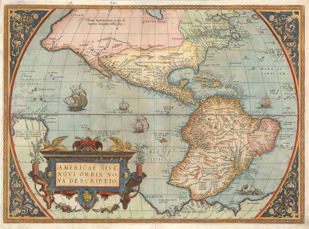
Americae Sive Novi Orbis Nova Descriptio.
1572 (undated) 14.5 x 20 in (36.83 x 50.8 cm) 1 : 40000000
1572 (undated) 14.5 x 20 in (36.83 x 50.8 cm) 1 : 40000000
Description
This is Abraham Ortelius' map of the Western Hemisphere, considered to be the 'first map of the Americas to appear in a modern atlas' (Schwartz). Ortelius' success and the spread of his atlas made this fine map the standard - and best - representation of the Americas during the initial period its colonization.
On The Map
Given how recently the Western Hemisphere had come to the attention of European scholars, the outline of the continent is remarkably accurate and recognizable. The American Northeast is dominated by Nova Francia and the St. Lawrence, showing evidence from Cartier's voyages. The Caribbean and eastern South America are shown with remarkable accuracy. Beyond the Strait of Magellan Tierra del Fuego appears not as an island but as part of a massive southern continent, the apocryphal Terre Australis, extending all the way to New Guinea. The Pacific Ocean itself appears optimistically far narrower than its actual width, with New Guinea appearing south of Quivira and the strait of Anian. The Pacific coast exhibits significant distortion both in North and South America. The Chilean coast features the 'Potato-shaped' bulge also found on Mercator's map. In Mexico and the Southwest, Coronado's placenames of Ceuola, Tiguex and Quivira appear. Peru and the Rio de la Plata are well-detailed, although the size of the latter is exaggerated.Ortelius' Sources
The general shape of the continent and many of its details were drawn from those appearing on Ortelius' friend and fellow mapmaker Gerard Mercator's massive (and unobtainable) 1669 world map. Much of the fine detail was derived from Spanish sources - itself a remarkable accomplishment, as the Spanish and Portuguese were notoriously close-lipped regarding their discoveries in the New World. These sources are nameless - but the sharp detail within the Spanish sphere gives the game away. The Pacific coast, Mexico, the Caribbean and the Gulf, and South America all reveal detail from a source familiar with the Spanish explorations.Elegant and Distinctive
In addition to its revealing detail, Ortelius' map is a beautiful work, exhibiting the master engraving of Franz Hogenberg. Ships sail the stippled oceans, and a sea monster prowls the South Atlantic. The garlanded, strapwork cartouche is surmounted with winged lions. The map's typography is clear and legible throughout.Publication History and Census
Americaewas among the fifty-three maps appearing in the very first 1570 edition of the Theatrum and versions of the map appeared in every subsequent edition until the last, 1624. The copperplate was replaced twice during this run, and each of the three plates experienced some revision during this extraordinarily long print run. This first plate was used until 1575, approximately 1750 copies having been printed. Some 225 of these belonged to the 1572/3 German text edition, with which this example corresponds. Examples of various editions of this map are well represented in institutional collections. The German edition of the Theatrum is catalogued in 13 libraries in OCLC.CartographerS
Abraham Ortelius (April 14, 1527 - June 28, 1598) also known as Ortels, was a cartographer, geographer, and cosmographer of Brabant, active in Antwerp. He was the creator of the first modern atlas, Theatrum Orbis Terrarum and is a seminal figure in the history of cartography. Along with Gerard Mercator and Gemma Frisius, he was a founder of the Netherlandish school of cartography. His connections with Spain - culminating in his 1575 appointment as Royal Cartographer to King Phillip II of Spain - gave him unmatched access to Spanish geographical knowledge during a crucial period of the Age of Discovery. Ortelius was born in 1527 in Antwerp. In 1547 he entered the Antwerp Guild of Saint Luke as an illuminator of maps. He began trading in books, prints, and maps, traveling regularly to the Frankfurt book and print fair, where in 1554 he met Mercator. He accompanied Mercator on journeys throughout France in 1560 and it was at this time, under Mercator's influence, that he appears to have chosen his career as a scientific geographer. His first published geographic work appeared in 1564, an eight-sheet cordiform world map. A handful of other maps preceded the 1570 publication of the first edition of the Theatrum Orbis Terrarum, which would prove to be his life work. Appearing with but 53 maps in its first edition, Ortelius' work expanded with new maps added regularly. By 1592, it had 134 maps. Many of Ortelius' maps remained the standard for nearly a century. He traveled extensively, but his genius was as a compiler, locating the best informed maps on which to base his own. His contacts throughout Europe and extending even (via the Portuguese) to the Far East were formidable. Moreover, many of his maps were based on his own scholarship, particularly his historical works. His theories of geography were particularly ahead of his time with respect to the notion of continental drift, the possibility of which he mused on as early as 1596, and which would be proven correct centuries later.
In a sense his greatest achievement was his successful navigation of the religious and political violence endemic to his city throughout his adult life: The Dutch Revolt, or Eighty Years' War (1568 - 1648), fully embroiled Antwerp. Although outwardly and officially recognized as Catholic (Arias Montanus vouched for Ortelius' Catholic orthodoxy prior to his appointment as Royal Geographer), Ortelius was able to separate himself from the religious furor which characterized the war in the low countries. Ortelius showed a glimpse of himself in a letter to a friend, regarding humanist Justus Lipsius: 'I do not know whether he is an adherent of the Pope or a Calvinist, but if he has ears to hear, he will neither be one nor the other, for sins are committed on both sides'. Ortelius' own explorations of Biblical history in his maps, and the Christogram contained in his own motto, suggest him to be a religious man, but his abjuration of political religious authorities mark him as an individualist. His tombstone at St Michael's Præmonstratensian Abbey in Antwerp bears the inscription, Quietis cultor sine lite, uxore, prole. ('served quietly, without accusation, wife, and offspring.') More by this mapmaker...
Franz Hogenberg (1535 - 1590), often called 'Master Franz,' was a Flemish engraver active in the late 16th century. Hogenberg was born in Mechelen, the son of Nicolas Hogenberg, where he trained under the cartographer H. Terbruggen. He later relocated to Antwerp where he achieved success as an engraver, working with Abraham Ortelius, Hieronymus Cock, and others. In 1568, his name appeared on the list of those banned from the Netherlands by the Duke of Alva, forcing his family to flee to London. There he engraved for Christopher Saxon's Atlas of England and Wales. By 1570 he emigrated to Germany settling in Cologne. In Cologne he married his second wife, Agnes Lomar, with whom he had six children. In 1579 the couple were briefly imprisoned for holding illicit secret religious meetings, but were released in short order. Along with German cleric George Braun (1541 – March 10, 1622), Hogenberg issued the highly influential city atlas Civitates Orbis Terrarum. The six volume work, with some 546 views, was published between 1572 and 1617 and intended a companion to Abraham Ortelius' Thatrum Orbis Terrarum - thus certain obvious stylistic similarities. In compiling the Civitates Hogenberg took on the role of engraver while most of the editing was left to Georg Braun. Hogenberg died in Cologne, Germany, before the Civitates was completed. After his death, Hogenberg's work was continued by his son, Abraham Hogenberg, who, under the direction of Agnes, his mother, took over his father's enterprise at just 20. Learn More...
Source
Ortelius, Abraham Theatrum oder Schawplatz des erdbodems, warin die Landttafell der gantzen weldt, mit sambt aine der selben kurtze erklarug zu sehen ist... Antwerp, 1572
Abraham Ortelius' magnum opus, Theatrum Orbis Terrarum, was the world's first regularly produced atlas, which 'set the standards for later atlases . . . It was the first undertaking of its kind to reduce the best available maps to an uniform format.' (Koeman) A modestly-sized work of fifty-three maps in its first edition of May 1570, it was an immediate success: there were three further editions that year, and the work remained in print for a total of 32 editions, the last of which was 1641, well after its author's 1598 death. Ortelius added to his atlas constantly, and by 1595 the Theatrum contained 147 maps. Ortelius is renowned generally as an editor, and indeed much of the Theatrum is compiled from a variety of sources: in such cases, Ortelius was scrupulous in naming his sources. But Ortelius was also a mapmaker in his own right: many of his maps are a distillation of various sources into his own work, and there were many maps - particularly in his atlas of Biblical and ancient history Parergon - which were entirely Ortelius' work. In his role as an editor, Ortelius followed in the footsteps of Munster, whose Cosmographia was, until Ortelius, the best window on the world for the curious European reader. In terms of the artistry of his maps, Ortelius oversaw the first great flourishing of copperplate engraving in the service of cartography to occur in Northern Europe. Ortelius' work provided the model for the atlases of Mercator, Hondius, Blaeu and all their progeny in the 17th century - many of whom were to produce faithful editions of Ortelius' maps in their own productions.
Condition
Very good. Centerfold mend with very slight loss, else excellent with a bold strike and fine hand color.
References
OCLC 1050160600. Rumsey 10000.000. Van den Broecke, Ort9 2.2. Burden, P., The Mapping of North America, 39, State 2. Schwartz, S. and Ehrenberg, R., The Mapping of America, p. 69.