
This item below is out of stock, but another example (left) is available. To view the available item, click "Details."
Details
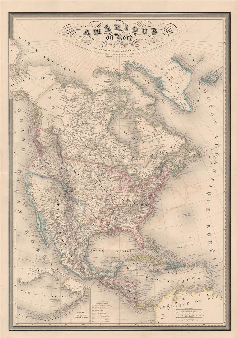
1849 Dufour Map of North America w/ Republic of Texas
1849 (dated) $1,200.00
1842 Dufour Map of North America w/ Republic of Texas
AmeriqueNordTexas-dufour-1842$825.00

Title
Amérique du Nord par A. H. Dufour...
1842 (dated) 37 x 26 in (93.98 x 66.04 cm) 1 : 10256000
1842 (dated) 37 x 26 in (93.98 x 66.04 cm) 1 : 10256000
Description
A fine example of A.-H. Dufour's 1842 map of North America, including the Republic of Texas. The map covers the entire North American continent and Greenland, embracing Mexico, an independent Texas, Central America, and the Caribbean. An inset in the lower left corner details the Bering Sea and the Aleutian Islands. This map appeared in several editions of the Dufour/ Andriveau-Goujon elephant folio atlas, but this edition is significant for its inclusion of the Republic of Texas - and as such this makes it one of the earliest European maps to do so. The map also recognizes American claims to British Columbia - further underscoring the then hot political tensions between France and England.
France Recognizes the Republic of Texas
When Texas seceded from Mexico on April 21, 1836, it immediately sought legitimacy through diplomatic appeals to major world powers - most of which at that time were European nations. Most European powers were reluctant to recognize the self-proclaimed Republic until it became clear that it could survive and what diplomatic ramifications, if any, formal recognition might yield. Nonetheless, France under King Louis Philippe recognized Texas on September 25, 1839. This act may have been partially trade inspired, and partially motivated by French antipathy towards Mexico following the First French Intervention or Pastry War (1838 - 1839). Recognizing Texas diplomatically allowed France to open official trade channels, particularly for cotton, a vital commodity in Europe and an increasing cause of tension between France and Britain. Moreover, the recognition of Texas accelerated the destabilization of Mexico, increasing the probability that any colonial aspirations the French may have had in potentially seizing California (something they were considering) would be successful.Republic of Texas
The Republic of Texas was a short-lived nation established in March 1836 when it seceded from Mexico. Following the independence of Mexico from Spain, the American Stephen Fuller Austin lead a group of 300 Empresarios to settle Texas, near Austin, where they received a grant from the Mexican government. As more Americans moved to Texas, resentment and strife began to build between the American settlers and Mexican authorities. This and other factors ultimately led to the Texan Revolution in 1835 and the declaration of Texan independence in 1836. Texas remained an independent republic until it joined the United States 10 years later in 1846. France recognized the Republic of Texas early, and as such, this is one of the earliest foreign-published maps to show the nascent nation.Texas Borders
The borders of the Republic of Texas were in dispute from the earliest days of the Texan Revolution. The Republic-claimed borders followed the Treaties of Velasco between the newly created Texas Republic and Mexican leader, Antonio López de Santa Anna. The treaties established an eastern boundary following the 1819 Adams-Onís Treaty between the United States and Spain, which established the Sabine River as the eastern boundary of Spanish Texas and western boundary of the Missouri Territory. The Republic's southern and western boundary with Mexico was more nuanced. Texas claimed the Rio Grande del Norte as its western and southernmost border, while Mexico argued for a boundary much further east at the Nueces River. When Texas was annexed into the United States, the agreement followed the Republic claimed boundary, thus absorbing Mexican claimed territory as far west as Santa Fe. This escalated already existing tensions between the United States, the former Republic of Texas, and Mexico, ultimately triggering for the Mexican-American War (1846 - 1848).54-40 or Fight! American Claims to British Columbia
Dufour includes a dramatic presentation of American claims to British Columbia - at the expense of Britain. Following the transcontinental crossing of North America by the British Northwest Company sponsored explorer Alexander MacKenzie (1792 - 1793), and the American expedition of Lewis and Clark up the Missouri to the mouth of the Columbia River (1804 - 1806), it became apparent that control of the fur and resource rich Pacific Northwest would bring wealth and power to whomever could assert sovereignty. The American tycoon John Jacob Astor (1763 - 1848), with the permission of President Thomas Jefferson, was the first to attempt a permeant trading colony in the region, founding Astoria on the Columbia River in 1811. This led to a confrontation with the established British-Canadian Northwest Company over the valuable territory. Americans in the 1820s through the 1840s argued that most of the Pacific Northwest should be part of the United States as a legacy of the 1803 Louisiana Purchase. England, on the other hand, argued for residual claims to the region derived from the MacKenzie Expedition (1825 - 1827) and its fur trading empires: The Northwest Company and the Hudson Bay Company. The Oregon Dispute, as it came to be known, evolved into a geopolitical issue between the British Empire and the United States, especially after the War of 1812. Americans adopted the slogan '54-40 or Fight!' until the Oregon Question was finally resolved roughly along the current borderline by the 1846 Oregon Treaty.Publication History and Census
This map was engraved and published in 1842 by Jean Andriveau-Goujon. It was drawn by Adolphe Hippolyte Dufour (1795 - 1865), also known as Auguste-Henri Dufour, and engraved by Jacques-Michel Flahaut. The typography is the work of one 'Warin', or possibly 'Varin', who remains elusive. Variants of the map date to as early as 1829, possibly slightly earlier, and as late as 1887. It was issued both in the Andriveau-Goujon / Dufour Atlas de Choix, ou Recueil des Meilleures Cartes de Geographie Ancienne et Moderne Dressees par Divers Auteurs, and separately as a dissected folding map. While the atlas and the individual maps in it are not rare in late editions, editions with maps depicting the Republic of Texas are exceedingly scarce, as are separate examples of the map. We note no separate examples of the map or the atlas in the OCLC from 1836 - 1845. Scarce to the market.CartographerS
Adolphe Hippolyte Dufour (1795 - 1865), also known as Auguste-Henri Dufour, was a Paris based map and atlas publisher active in the middle to late 19th century. Dufour claimed to be a student of another French cartographer, Emile Lapie. He is known to have worked with numerous other French cartographers, publishers, and engravers of the period including Andriveau-Goujon, Charles Dyonnet, and Duvotenay. His corpus includes numerous maps and atlases, the most striking of which is probably his monumental elephant folio Atlas Universel Physique, Historique et Politique Geographie Ancienne et Moderne. Dufour's student and successor was Alexandre Vuillemin. More by this mapmaker...
Eugène Andriveau-Goujon (1832 - 1897) was a map publisher and cartographer active in 19th century Paris. The firm was created in 1825 when Eugène Andriveau married the daughter of map publisher Jean Goujon - thus creating Andriveau-Goujon. Maps by Andriveau-Goujon are often confusing to identify as they can be alternately singed J. Goujon, J. Andriveau, J. Andriveau-Goujon, E. Andriveau-Goujon, or simply Andriveau-Goujon. This refers to the multiple generations of the Andriveau-Goujon dynasty and the tendency to republish older material without updating the imprint. The earliest maps to have the Andriveau-Goujon imprint were released by Jean Andriveau-Goujon. He passed the business to his son Gilbert-Gabriel Andriveau-Goujon, who in 1858 passed to his son, Eugène Andriveau-Goujon, under whose management the firm was most prolific. Andriveau-Goujon published numerous fine pocket maps and atlases throughout the 19th century and often worked with other prominent French cartographers of the time such as Brue and Levasseur. The firm's stock was acquired by M. Barrère in 1892. Learn More...
Jacques-Michel Flahaut (1791 - March 20, 1864) was a Paris-based French engraver active in the middle part of the 19th century. Flauhat was born in Paris and worked extensively in Paris mapmaking communities. He engraved for Pierre M. Lapie (fl. 1779 - 1850) and his son Alexandre Emile Lapie (fl. 1809 - 1850), as well as for Adolphe Hippolyte Dufour (1795 - 1865), and Jean Andriveau-Goujon. He was based at 9 Rue de L'est. Learn More...
Source
Atlas de Choix, ou Recueil des Meilleures Cartes de Geographie Ancienne et Moderne Dressees par Divers Auteurs, (Paris: Andriveau-Goujon) 1842.
The Atlas de Choix, ou Recueil des Meilleures Cartes de Geographie Ancienne et Moderne Dressees par Divers Auteurs was introduced by Jean Andriveau-Goujon and Adolphe Hippolyte Dufour (Auguste-Henri Dufour; 1795 - 1865) around 1829. It was their finest atlas and arguable the best mid-19th century French atlas. It was a lavishly produced elephant folio containing as many as 60 steel plate (later lithograph) maps of all parts of the world. The atlas had a long print run - more than 55 years - being taken over by Jean Andriveau-Goujon's successors, Gilbert-Gabriel Andriveau-Goujon and Eugène Andriveau-Goujon. Unlike many French atlases of the period, this grand atlas enjoyed regular updates and revisions intended to keep it current.
Condition
Very good. Minor toning. Some offsetting. Wear on old centerfold.
References
Rumsey 12050.060 (1852 edition).