This item has been sold, but you can get on the Waitlist to be notified if another example becomes available, or purchase a digital scan.
1844 Perrot Chart or Map of Ancient Creatures
AncientCreatures-perrot-1844$925.00

Title
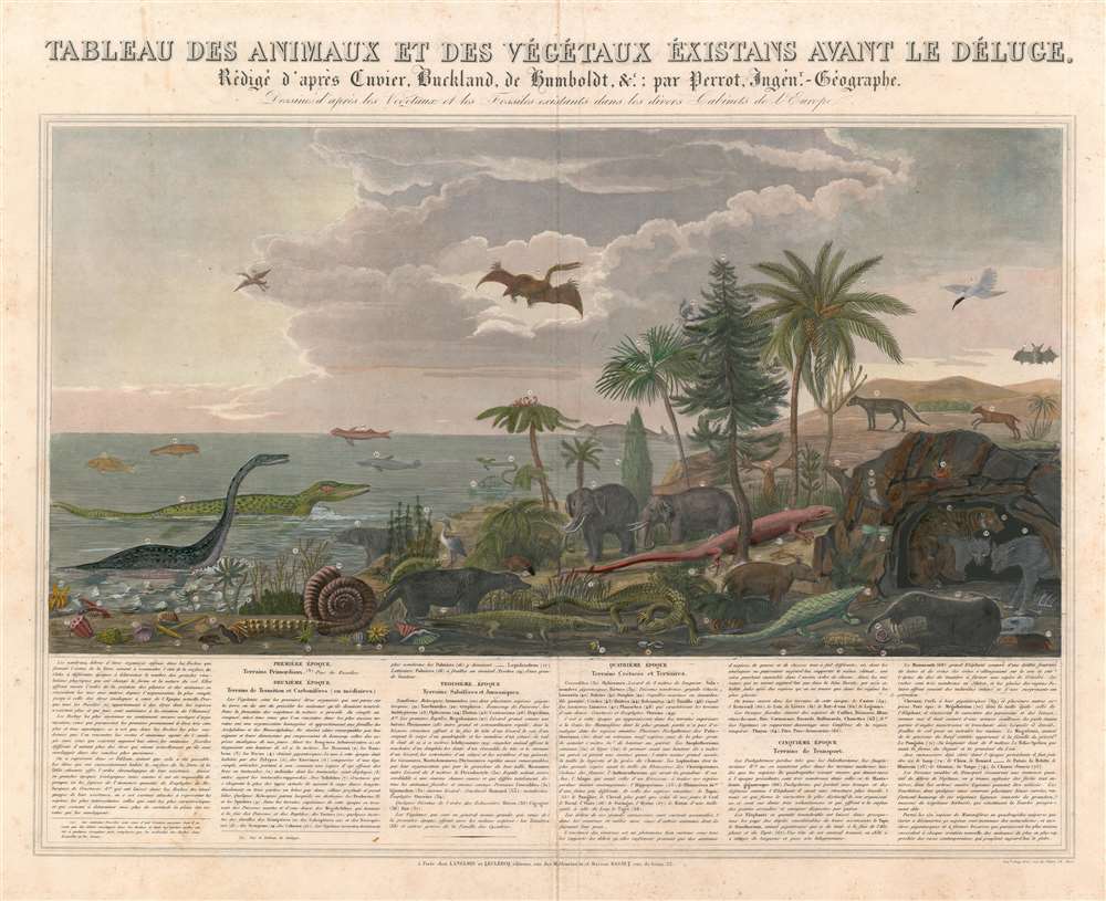
Tableau des Animaux et des Végétaux Éxistans Avant le Déluge, Rédigé d'après Cuvier, Buckland, de Humboldt etc. par Perrot, Ingénr.-Geographe. Dessiné d'après les Végétaux et les Fossiles existants dans les divers Cabinets de l'Europe.
1844 (undated) 20 x 24.5 in (50.8 x 62.23 cm)
1844 (undated) 20 x 24.5 in (50.8 x 62.23 cm)
Description
Filled with strange and unfamiliar creatures, this is 1844 Aristide Michel Perrot chart of antediluvian animals. Seventy-five different animals and plants, dating from the epoch just after primordial times to the era before the last ice age, are depicted here, with Perrot having consulted fossil collections to create this stunning piece. A narrative situated below the chart traces the evolution of these creatures across five historical epochs, presenting the plants and animals illustrated above in a sort of context. Plesiosaurs, ichthyosaurs, and pterodactyls are among the dinosaurs illustrated alongside mastodons and mammoths. Some more familiar animals, such as pangolins, wolves, and bats, are also included. The juxtaposition of the dinosaurs alongside beavers, bats, and herons gives the piece an aura that is both amusing and jarring.
Publication History and Census
This chart was created by Aristide Michel Perrot and published by the Langlois and Leclercq firm and the Basset firm in 1844. We are aware of only one other known example which is part of the Wellcome Collection in London.CartographerS
Aristide Michel Perrot (1793 - 1879) was a French geographer, cartographer, and essayist active during the 19th century. Perrot specialized in miniature maps that appear in numerous French atlases. Perrot was also a prolific writer and his works include geographic lexicons and several essays. More by this mapmaker...
André Basset (Bassett; fl. 1768 - 1784) was a well-known French publisher and engraver active on the Rue St. Jacques, Paris, during the 18th and 19th centuries. His office was located at the corner of Rue Saint Jacques and of Mathurins, à l'enseigne de Sainte Geneviève. The firm is closely aligned with the Chéreau family of printers and engravers, with whom they were connected with multiple, often incestuous, marriages and remarriages. Basset was best known for the production of low-cost optical views of European cities and events. However, the firm also produced games, maps, and other prints. The firm was taken over by Paul-André Bassett (1759 - 1829) in 1784. Paul-André Bassett himself retired in 1819, but the business continued under various family members until 1865. Learn More...
Condition
Good. Verso reinforcement along original centerfold. Exhibits soiling and foxing. Blank on verso.
References
Wellcome Library no. 500972i