
Basset, André (Bassett)

André Basset (Bassett; fl. 1768 - 1784) was a well-known French publisher and engraver active on the Rue St. Jacques, Paris, during the 18th and 19th centuries. His office was located at the corner of Rue Saint Jacques and of Mathurins, à l'enseigne de Sainte Geneviève. The firm is closely aligned with the Chéreau family of printers and engravers, with whom they were connected with multiple, often incestuous, marriages and remarriages. Basset was best known for the production of low-cost optical views of European cities and events. However, the firm also produced games, maps, and other prints. The firm was taken over by Paul-André Bassett (1759 - 1829) in 1784. Paul-André Bassett himself retired in 1819, but the business continued under various family members until 1865.
AKA: Bassett
A bastion of Europe against Ottoman invasion.
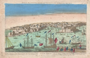
Vue de Malte. (Vue de la Partie Sed Est de la Ville Capitale de Malte.)
$500.00
Acquire
- Digital Map Information
- Suitable for large format printing
- DPI: 300
- File Size: 6.33 MB
- File Type: ZIP / TIFF
- ICC color profile embedded
- Delivered instantly via download link
An uncommon c. 1780 Chez Basset vue d'optique of Valletta, capital of Malta. The view reveals a busy and well-defended harbor. (more details)
Worldwide costumes of men and women.
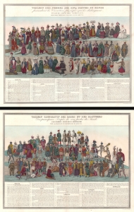
Tableau des Femmes des Cinq Parties du Monde présentant les Caractères physiques qui les distinguent et leurs costumes nationaux. / Tableau Comparatif de Races et des Costumes Des principaux Peuples des cinq parties du Monde.
$1,500.00
Acquire
- Digital Map Information
- Suitable for large format printing
- Full resolution TIFF file
- ICC color profile embedded
- Delivered instantly via download link
These are c. 1830 Ferdinand Victor Perrot comparative charts of the women and men of the world. (more details)
Fantastic separate issue example of this awesome chart!
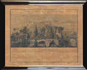
Tableau Pittoresque des Merveilles de la Nature.
$950.00
Acquire
- Digital Map Information
- Suitable for large format printing
- DPI: 300
- File Size: 4.52 MB
- File Type: ZIP / TIFF
- ICC color profile embedded
- Delivered instantly via download link
This is a separate issue c.1840 Aristide Michel Perrot comparative chart illustrating the wonders of the nature. The chart depicts 58 different numerically identified natural wonders occurring throughout the world. A table, situated in the bottom quarter of the ... (more details)
Incredible separate issue example of this beautiful chart!
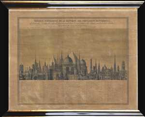
Tableau Comparatif de la Hauteur des Principaux Monuments de toutes les Parties du Monde, présentant leur Configuration, les details éxacts de leur élévation, et la Date de leur Construction.
$950.00
Acquire
- Digital Map Information
- Suitable for large format printing
- DPI: 300
- File Size: 5.24 MB
- File Type: ZIP / TIFF
- ICC color profile embedded
- Delivered instantly via download link
This is a separate issue c.1840 Aristide Michel Perrot comparative chart of the heights of the monuments of the world. The chart depicts 71 different numerically identified monuments located throughout the world, although the majority are in Europe, and the ... (more details)
Vexillological chromolithograph.
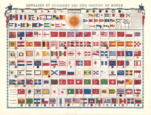
Pavillons et Cocardes des Cinq Parties du Monde.
$500.00
Acquire
- Digital Map Information
- Suitable for large format printing
- File Size: 26.82 MB
- File Type: ZIP / TIFF
- ICC color profile embedded
- Delivered instantly via download link
A vexillological chromolithographic delight, this is a rare separate issue c. 1862 flag chart. Flags are organized by region, with French flags at the top, followed by those of England and other European powers, which in turn are followed by African, Asian, and American flags. Among the more interesting flags are the Russian Postal Ensign, the white elephant flag of Siam (Thailand), the Cockerel flag of Pegu (Burma), and the Dragon flag of China. A large wind rose appears at top center. (more details)
Orders and Honors in a Changing Europe.
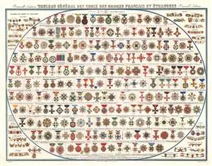
Tableau Général des Croix des Ordres Français et Étrangers. Nouvelle Édition.
$400.00
Acquire
- Digital Map Information
- Suitable for large format printing
- Full resolution TIFF file
- ICC color profile embedded
- Delivered instantly via download link
This spectacular c. 1862 André Basset chromolithographic chart illustrates the orders of chivalry, decorations, and medals of France and dozens of foreign states. Hundreds of brilliantly colored crosses, stars, badges, collars, and ribbons transform the complex hierarchy of 19th-century honors into an encyclopedic visual display. Published during the reign of Napoleon III, the chart presents a remarkable portrait of the international world of rank, military distinction, diplomacy, and royal patronage on the eve of the political transformations that would reshape Europe later in the century. (more details)