
1829 Johnson / Smith, Elder, and Co. Map of Antigua

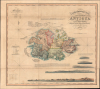

A New and Improved Map of the Island of Antigua, in the West Indies.
Waning Days of Antigua's Plantation Economy.
- Digital Map Information
- Suitable for large format printing
- Full resolution TIFF file
- ICC color profile embedded
- Delivered instantly via download link
Waning Days of Antigua's Plantation Economy.
This is J. Johnson's rare 1829 folding map of Antigua, published by Smtih, Elder, and Co. It holds both cartographic and historical significance, being the only major map of Antigua produced between 1793 and 1852, and, having been issued on the eve of the abolition of slavery, capturing the island in the late stages of the plantation slavery economy.A Closer Look
The map covers the island of Antigua as well as surrounding waters, indicating navigational information such as soundings, hazards, shoals, and anchorages on the water. Detailed sailing instructions explain how to reach the main settlement of Saint John's, advising that the most direct route along the north side of the island is both dangerous and difficult. In addition to the navigational information and sailing directions, five aquatint views appear at bottom-left to aid sailors in identifying landmarks on their way into Saint John's.The island is divided into parishes, which are color-shaded for distinction, and whose areas are listed in a table at top-left. The parishes are themselves divided into divisions. Topography is indicated by hachure, while settlements (notably Saint John's on the west side of the island), groupings of 'Negroes Houses', windmills, cattle mills, steam mills, chapels, churches, roads, forts, and batteries are indicated throughout. The naming of windmills often doubles as a means of naming plantations and their owners. A population table at bottom-left lists both the white and enslaved population of the island at intervals since 1720, reflecting a ratio of enslaved to enslavers that was common in the New World, between 5:1 and 10:1 depending on the year.
J. Johnson's Planned Series of Views in the West Indies
This map was part of a highly ambitious project by the enigmatic author J. Johnson, about whom little is known, titled A Series of Views in the West Indies: engraved from drawings taken recently in the islands… Planned as a five-volume work, Johnson aimed for the highest quality of design and print, explaining the impressive level of detail, exquisite hand-coloring, and fine aquatint views. He expected the work to prove popular with plantation owners throughout the West Indies, as well as merchants and investors in Britain. This supposition was reasonable, but Johnson did not anticipate the coming collapse of the plantation system; Britain's Parliament had outlawed the slave trade in 1807 and would soon outlaw slavery itself in 1833. Johnson also failed to foresee that plantation owners on one Caribbean island were not especially interested in other islands. As a result, Johnson faced mounting debts and only published the first three parts of the five-part project (this map was included with Part III). In an attempt to rescue the project, he published an abridged edition focusing only on Antigua, where he expected the most commercial success, titled An Historical and Descriptive Account of Antigua…. In the end, few copies of A Series of Views in the West Indies or An Historical and Descriptive Account of Antigua… were printed, while the map was also likely issued separately, as clients often requested only specific parts of Johnson's work.Wider Historical Context
At the turn of the 19th century, Antigua stood as one of Great Britain's most lucrative Caribbean possessions, its economy entirely tethered to the brutal machinery of plantation slavery. The island was transformed into a hyper-efficient sugar monoculture, where vast estates like Betty's Hope (center towards right here) dominated the landscape. The wealth generated from this human exploitation not only enriched British plantation owners and their investors but also funded the militarization of the island, notably at English Harbour on the island's south side, as the British Royal Navy secured the region to protect its high-stakes sugar trade from European rivals.As the 19th century progressed, the plantation complex faced mounting pressures from soil exhaustion, volatile sugar markets, and the rising British abolitionist movement. Following the ban on the Transatlantic slave trade in 1807, planters could no longer import labor and were forced to sustain their workforce through natural increase, though the grueling, hazardous conditions of estate labor remained largely unchanged. When the British Empire finally enacted emancipation, Antigua took a unique path: on August 1, 1834, local planters bypassed the transitional 'apprenticeship' system used elsewhere and opted for immediate emancipation. However, this was a calculated economic strategy rather than a humanitarian gesture. By releasing the newly freed population without land or financial compensation, the planter elite maintained a total monopoly on arable land, effectively forcing Afro-Antiguans back onto the plantations as low-wage laborers to preserve the island's rigid economic hierarchy.
Publication History and Census
This map was prepared by J. Johnson, engraved by James and Josiah Neele, and published by Smith, Elder, and Co. in London in 1829. It is very rare, only being separately cataloged by the National Archives U.K. and the Dockyard Museum (English Harbour, Antigua), while the An Historical and Descriptive Account of Antigua… is held by Hamilton College and Trinity College (in Connecticut). The map has only come to market a small handful of times in recent decades.Cartographers
Smith, Elder, and Company (1816 - 1917) was a publishing firm based in London that was founded by two Scottish men: George Smith (1789 - 1846) and Alexander Elder (1790 - 1876). Founded in 1816, Smith, Elder and Company’s first three years in business were spent selling pens, paper, pencils, ink, account books, and other similar items, along with both new and used books, journals, and musical scores. A major portion of their clientele was officers from the East India Company, which significantly helped build the firm’s financial strength. Three years later the firm entered the publishing world when they released Sermons and Expositions on Interesting Portions of Scripture by John Morison. A third partner, Patrick Stewart, joined the company in 1824, and the company moved to Cornhill. The firm continued publishing small works, particularly editions meant to be bought as gifts, until 1843 when George Smith’s son, George Murray Smith (March 18, 1824 – April 6, 1901), who had joined the firm in 1838 and worked his way up through the ranks to become head of the small publishing arm of the business, agreed to publish the first volume of Modern Painters by John Ruskin, which launched a very lucrative thirty-year relationship between the publishing house and Ruskin. Other major successes followed, but very few would compare to George Murray Smith’s decision to publish Charlotte Brontë’s Jane Eyre, which created a deep, personal friendship between the publisher and author. Smith also managed to entice many renowned authors to publish with the firm, including Robert Browning, William Makepeace Thackeray, and Anthony Trollope. Smith, Elder, and Company began publishing their well-received literary journal The Cornhill in 1859, which published serialized novels by both Trollope and Thackeray in its first year. The first issue reportedly sold 120,000 copies. The firm continued to see success in the late 19th century. But, after Reginald Smith, George Murray Smith’s son-in-law, died on December 26, 1916, no one was left to continue running the company. All book rights and remaining stock were bought by John Murray in May 1917. Further Details...
Josiah Neele (March 30, 1804 - March 22, 1876) was a British map engraver, printer, and publisher active in London during the middle part of the 19th century. Neele was the son of Samuel John Neele (1758 - 1824), also a prominent map engraver. He apprenticed under his father along with Ebenezer Stalker (1780 - 1847) with whom he briefly partnered until 1825. At that time, he went into business with his uncle, George Neele, and his brother, James Neele. George retired in 1826, ending that partnership, after which the brothers published until 1829 under the imprint of 'James and Josiah Neele'. Josiah subsequently continued the business under his own name, operating from their former offices at 352 Strand, until 1836, when he declared bankruptcy. In 1845 he married Eliza Atwood of Haverfordwest and in the wedding documents he is described as a stationer. He retired to Wiltshire in 1871 and died five years later in 1876. Further Details...
Source
Johnson, J., An historical and descriptive account of Antigua..., (London: J. Johnson) 1829.
Condition
Excellent. Dissected and mounted on linen for folding.
References
National Archives U.K.: CO 700/ANTIGUA10; Kapp, K., ‘The Printed Maps of Antigua, 1689-1899’, in in R.V. Tooley (ed.), The Map Collector’s Circle, no. 55 (1969), no. 65; Penfold, P.A. Map and Plans in the Public Record Office: 2. America and West Indies (London: Her Majesty’s Stationary Office, 1974), no. 3051, p. 533. With the book: OCLC: 14510282. Watkinson Library, Trinity College (Dublin): FOLIO F2035 .J6; S.P. Lohia Collection (private holding): 5605.