
1845 Brué and Picquet Map of the West Indies and Central America

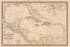
Carte Générale des Îles Antilles, des Îles et Bancs de Bahama, des États-Unis de l'Amérique-Centrale, de la Mer du Mexique, etc.
The Caribbean in striking detail.
- Digital Map Information
- Suitable for large format printing
- File Size: 45.19 MB
- File Type: ZIP / TIFF
- ICC color profile embedded
- Delivered instantly via download link
The Caribbean in striking detail.
This is a beautiful and wonderfully detailed Adrien-Hubert Brué and Charles Picquet 1845 map of the West Indies. Published 4 years after the Federal Republic of Central America ceased to exist, the map still illustrates that short-lived Central American republic.A Closer Look
Depicting the region from the Gulf Coast of the United States south to northern South America, islands throughout the Caribbean are illustrated and labeled from Cuba south to Trinidad and Tobago. The Bahamas appear in detail, with individual islands, straits, banks, and other locations all labeled. Cuba, Haiti, and Jamaica are all illustrated with the same level of detail, with coastal locations, cities, towns, lakes, and even road networks all noted. A table below Haiti lists the six administrative divisions of the island republic. Cities, towns, and coastal features are also identified throughout the rest of the Antilles. All the islands are shaded in different colors to indicate which colonial power claimed which island. A key to the color scheme appears just below the inset maps in the upper right corner. These focus on the Virgin Islands and the two French colonies, Martinique and Guadeloupe.Central America benefits from the same attention to detail. Cities, towns, villages, rivers, mountains, and coastal locations are all labeled. Countries are identified using outline color, with the largest, the Federal Republic of Central America, outlined in pink. However, Picquet's information must have been outdated because the Federal Republic of Central America ceased to exist in 1841.
The United Provinces of Central America
The United Provinces of Central America (1823 - 1839/1841) was a country in Central America that also went by the name Federal Republic of Central America. In September 1821, the Captaincy General of Guatemala declared independence from Spain. In January 1822, the First Mexican Empire annexed this territory, which would not regain its independence until 1823. Five states combined to create the Federal Republic: Costa Rica, El Salvador, Guatemala, Honduras, and Nicaragua. The Federal Republic based its government on that of the United States and adopted a constitution in November 1824. The first presidential election was held in April 1825, but the elected president, Manuel José Arce, had to make compromises to get elected. This led to a civil war from 1827 until 1829. A new president was elected in 1830, but the country again descended into civil war in 1838. By 1840, the states within the Federal Republic declared their independence, and the Federal Republic ceased to exist.Publication History and Census
This map was 'reviewed, corrected, and augmented' by Charles Piquet (or rather his son, Pierre-Jacques Picquet, since Charles died in 1827) and published by Piquet in 1845. The first edition appeared in 1832 and was created by Adrien-Hubert Brué. We note 4 examples of the present 1845 edition in OCLC, which are part of the collections at Florida State University, the University of Texas at Arlington, the Bibliothèque nationale de France, and the Biblioteca Nacional de España. Pierre-Jacques Picquet continued publishing editions of this map through at least the late 1850s. The Picquet firm's embossed seal and stamp appear just above the title.Cartographers
Adrien-Hubert Brué (March 20, 1786 – July 16, 1832) was a prominent French cartographer and geographer of the early 19th century. Born in Paris, Brué went to sea as a cabin boy at the age of twelve and, at fourteen, joined the Naturaliste, one of the two principal vessels of the Baudin Expedition (1800 - 1804) to the South Pacific. After returning to France, he devoted himself to cartography, earning distinction for the exceptional clarity, precision, and elegance of his maps. Brué drew many of his maps directly onto the copperplate, an innovative method he dubbed encyprotype. This technique produced exceptionally fine outlines, facilitated the careful revision of topography and relief, and allowed waterways to be differentiated by the weight of their engraved lines, making their relative importance immediately apparent. Brué eventually received the prestigious title Géographe du Roi, which he frequently appended to his signature, and in that capacity contributed to thousands of maps and numerous important atlases. Suffering from declining health, he retired to Sceaux, outside Paris, in search of cleaner air, but died there during the cholera epidemic of 1832. He was a member of the Central Commission of the Société de Géographie de Paris and an associate of the Geographical Society of London. Brué left numerous works unfinished at his death; several were published posthumously by his widow in 1834, before she transferred the business to Pierre-Jacques Picquet, son and successor of Brué's former associate Charles Picquet (1771 - 1827). Brué's maps continued to be revised and republished for decades, attesting to their enduring authority and commercial importance. Further Details...
Charles Picquet (April 15, 1771 – January 15, 1827) was a French cartographer active in Paris during the Napoleonic and post-Napoleonic Eras. Picquet was born in Romagna-sous-Montfaucon, Meuse, France. From about 1798 Picquet supplied maps to the Dépôt de la Guerre. From 1806 he was appointed to Napoleon's Cabinet Topographique. Being politically dexterous, he was able to retain this position after the fall of Napoleon under both Louis XVIII and Charles X. Under Louis XVIII he also obtained the Brevet de Géographe Ordinaire du Cabinet Topographique. He worked with the cartographer Adrien-Hubert Brué (1787 - 1832) on a major atlas project. When Charles Picquet died in 1827, his son, Pierre-Jacques Picquet, continued to publish under his father's imprint name well into the middle part of the 19th century. From roughly 1839, one J. Barthelemier also claimed to be the 'seul acquéreur et successor' of the 'ancienne maison Ch. Picquet' though it is unclear if he succeeded the younger Picquet or challenged his claim to succession. Barthelemier only published maps infrequently until the late 1850s, after which he maintained a more steady output until the early-mid 1870s. Further Details...
Condition
Very good. Light wear along original centerfold. Even overall toning. Closed margin tears professionally repaired on verso.
References
OCLC 39487189, 494437544, 431784860.