This item has been sold, but you can get on the Waitlist to be notified if another example becomes available, or purchase a digital scan.
1871 Petermann Geologic Map of the Appalachian Mountains
Appalachians-petermann-1871$100.00

Title
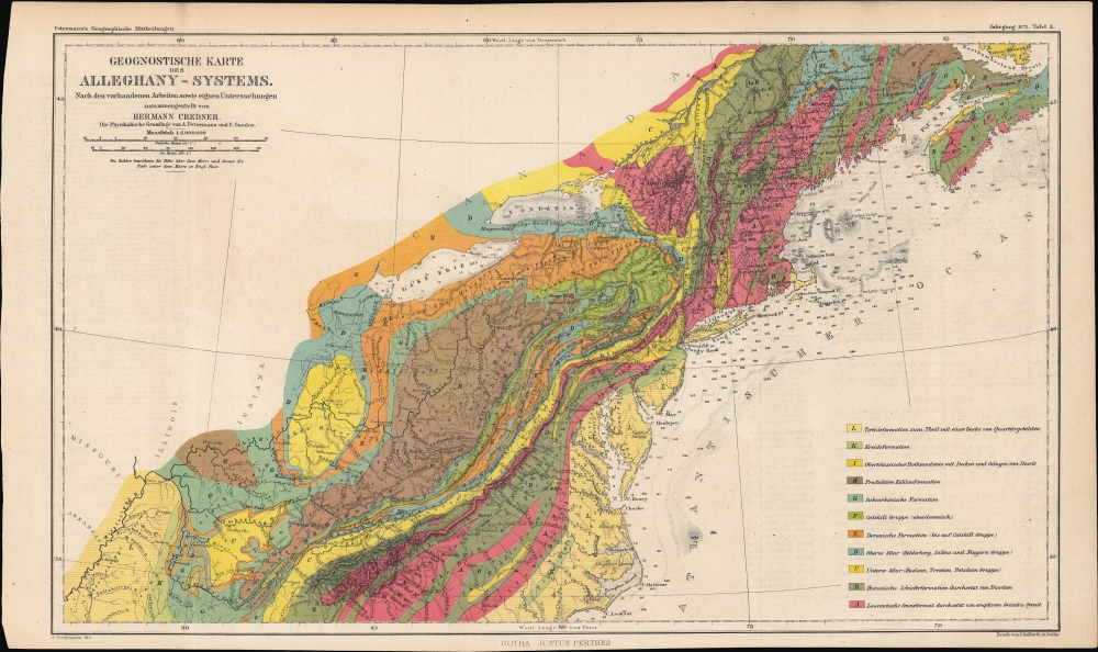
Geognostische Karte des Alleghany-Systems. Nach den vorhandenen Arbeiten sowie eignen Untersuchungen zusammengestellt von Herman Credner.
1871 (dated) 10 x 16.5 in (25.4 x 41.91 cm) 1 : 6000000
1871 (dated) 10 x 16.5 in (25.4 x 41.91 cm) 1 : 6000000
Description
A colorful geologic map of the Appalachian Mountains, produced in 1871 by Augustus Petermann and published by Justus Perthes for his Petermann's geographische Mitteilungen, a leading German geographical journal of the era.
The Appalachians would have attracted special attention at the time due to the increasing exploitation of coal deposits there in the mid-19th century. The region also would have had a special resonance for a German audience, given the large numbers of German immigrants and their descendants in Pennsylvania and elsewhere. It is worth noting that 'Appalachian Mountains' only became the standard name for these ranges in the late 19th century; at the time of publication, they were as often, if not more so, known as the 'Alleghenies,' explaining the latter term's use in the title.
A Closer Look
Coverage ranges from the Ohio River, Lake Erie, and Lake Ontario to the Atlantic Seaboard, reaching as far north as the St. Lawrence River and Prince Edward Island, and as far south as the Tennessee River, Blue Ridge Mountains, and Cape Hatteras. A legend at bottom-right explains the vivid color shading and abbreviations employed throughout, denoting different geological formations and eras. Waterways, areas of elevation, and cities are indicated throughout, with an emphasis on hills, knobs, mountains, gaps, and other features relevant to geology. Different mountain ranges and areas of elevation are labeled, from well-known ranges like the Adirondacks and White Mountains, to lesser-known features like the Ohio and Erie Heights. On the water, soundings are marked in English feet.The Appalachians would have attracted special attention at the time due to the increasing exploitation of coal deposits there in the mid-19th century. The region also would have had a special resonance for a German audience, given the large numbers of German immigrants and their descendants in Pennsylvania and elsewhere. It is worth noting that 'Appalachian Mountains' only became the standard name for these ranges in the late 19th century; at the time of publication, they were as often, if not more so, known as the 'Alleghenies,' explaining the latter term's use in the title.
Publication History and Census
This map was drawn by Carl Hellfarth, overseen by Augustus Petermann, and published by Justus Perthes Petermann's geographische Mitteilungen in 1871. It accompanied an article by Carl Hermann Credner, a leading German geologist of the day who had conducted extensive research in the Americas. The map is independently cataloged by the Pennsylvania State University, the British Library, and the Bibliothèque nationale de France, while the entire 1871 edition of Petermann's geographische Mitteilungen is more widespread in institutional collections.CartographerS
August Heinrich Petermann (1822 - 1878) was a German cartographer. Petermann attended the 'Geographische Kuntschule' (Geographica School of Art), which was started by Heinrich Berghaus with the support of Alexander von Humboldt, in Potsdam beginning in 1839. Students at the school were obliged to work on many of the school's contracts, including maps for several different atlases. Following his time in Potsdam, Petermann relocated to Edinburgh and London from 1845 to 1854, where he gained insight into the commercial aspects of the cartography business. In 1854, Petermann returned to Gotha, Germany and began working with the Perthes brothers publishers. While working with the Perthes brothers, Petermann founded the journal Petermanns Geographische Mitteilungen, published from 1855 until 2014, long one of the most prominent German-language geography journals. More by this mapmaker...
Carl Hellfarth (November 30, 1846 - July 12, 1918) was a German printer. Hellfarth was born in Gotha, Germany. He married Amalie Friederike Marie Möller (1850 - 1916) on June 16, 1873, and they had eight children. Learn More...
Condition
Good. Even toning. Slight offsetting. Areas of loss in the margins at top-left and bottom-left.
References
OCLC 910920274, 556322180.