
1972 Egyptian Surveying Authority Arabic Map of the Arabian Peninsula

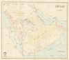
جزيرة العرب / [The Arabian Peninsula].
Saudi Drive for Self-Sufficiency in Agriculture.
Saudi Drive for Self-Sufficiency in Agriculture.
This is a scarce, large-format 1972 Arabic-language map of the Arabian Peninsula produced by the Egyptian General Survey Authority for the recently established King Abdul Aziz Research Center.A Closer Look
The map covers the Arabian Peninsula as well as portions of Iran, the Levant, and Egypt. Interestingly, national borders are not traced, presumably in order to highlight topographic detail, such as mountains, plains, and sandy deserts. Similarly, special attention is paid to the labelling of deserts, plains, waterways (including springs and wells عيون وآبار), and other topographic features, as indicated in the legend at bottom-right. Cities and towns are labelled throughout, with a dense cluster in the center of Saudi Arabia in Al-Qassim Province and Riyadh Province. Riyadh (الرياض) itself is rather diminutively marked as just another settlement along the various wadis of the region, which is unusual and highly suggestive.Although not mentioned here, it seems likely that this map was prepared for use in the study and planning of water resources and agriculture (Al-Qassim and immediate environs often being dubbed the 'breadbasket' of Saudi Arabia). This would be consistent with programs launched by the Saudi government beginning in the 1970s to introduce modern agricultural methods to foster a self-sufficient food supply. Part of these efforts to boost output was increasing use of the country's limited water supply, including aquifers, which would explain the specification of springs and wells here.
The King Abdul Aziz Research Center
This map is among the earliest works produced by the King Abdul Aziz Research Center (دارة الملك عبد العزيز), officially the King Abdulaziz Foundation for Research and Archives but better known simply as Darah (دارة). The center was established by royal decree by King Faisal in September 1972 to honor the legacy of King Abdul Aziz (Ibn Saud), the founder of Saudi Arabia, as well as to contain his personal library, a memorial hall dedicated to him, and a research center on the history of his reign and of the nation more generally. Located in the Al Murabba district of Riyadh near the Murabba Palace and the National Museum, it has become one of the premier historical centers in the young country and throughout the Middle East.Publication History and Census
This map was prepared on November 15, 1972, by the Egyptian General Survey Authority (الهيئة المصرية العامة للمساحة) for the King Abdul Aziz Research Center. We have been unable to locate any examples of this map in institutional collections.Cartographer
Survey of Egypt (c. 1898 - present; مصلحة المساحة المصرية) was the official surveying body of the Egyptian government from the turn of the 20th century until the founding of the Republic of Egypt. As Egypt was a British Protectorate for most of this period, the survey closely resembled government survey operations in other British colonies and protectorates. However, unlike many other surveys, the Survey of Egypt did not continue under its colonial name in the postcolonial period. Instead, in the independence era, the former Survey became known as the Egyptian General Survey Authority (الهيئة المصرية العامة للمساحة), from 1971 has been affiliated with the Ministry of Irrigation (وزارة الري). Further Details...
Condition
Very good. Some wear and toning on old fold lines.