1814 Thomson Map of Arabia, Egypt, and Abyssinia
Arabia-thomson-1814-2$550.00

Title
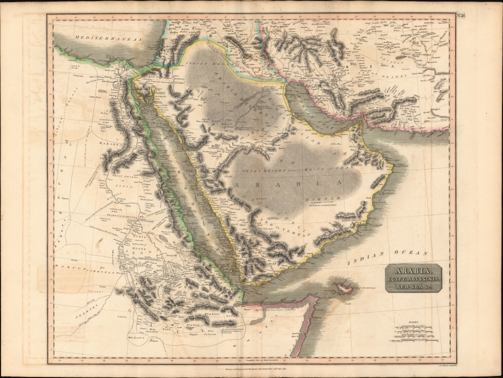
Arabia, Egypt, Abyssinia, Red Sea etc.
1814 (dated) 20.5 x 23.5 in (52.07 x 59.69 cm) 1 : 6500000
1814 (dated) 20.5 x 23.5 in (52.07 x 59.69 cm) 1 : 6500000
Description
This is an example of John Thomson's 1814 map of Arabia, Egypt, and Abyssinia. Centered on the Arabian Peninsula, Thomson's map covers from the eastern Mediterranean to the Horn of Africa, and from the Libyan Desert to Persia. The whole of this map is beautifully engraved in the minimalist English style pioneered in the early part of the 19th century. Relief is shown by hachure with towns, caravan routes, cities, and major topographical features identified.
A Closer Look
To create this map Thomson drew information from various sources including earlier maps and contemporary excursions into the region. He identifies several important pilgrimage routes across the Arabian Desert to Mecca, the great caravan routes from the Nile Valley into the interior of Africa, and the caravan route from Basra to Aleppo. The 1789 route of the frigate Venus through the Red Sea is especially noteworthy. Vice Admiral Rosily and the Venus explored the Red Sea thoroughly and declared it a practical and navigable avenue for European trade. Previously, the Red Sea had a reputation as dangerous and was largely avoided by the larger European trading vessels.Publication History and Census
This map is a steel plate engraving by J. and G. Menzies, and was prepared by John Thomson for inclusion in the 1814 first edition of Thomson's New General Atlas.CartographerS
John Thomson (1777 - c. 1841) was a Scottish cartographer, publisher, and bookbinder active in Edinburgh during the early part of the 19th century. Thomson apprenticed under Edinburgh bookbinder Robert Alison. After his apprenticeship, he briefly went into business with Abraham Thomson. Later, the two parted ways, John Thomson segueing into maps and Abraham Thomson taking over the bookbinding portion of the business. Thomson is generally one of the leading publishers in the Edinburgh school of cartography, which flourished from roughly 1800 to 1830. Thomson and his contemporaries (Pinkerton and Cary) redefined European cartography by abandoning typical 18th-century decorative elements such as elaborate title cartouches and fantastic beasts in favor of detail and accuracy. Thomson's principle works include Thomson's New General Atlas, published from 1814 to 1821, the New Classical and Historical Atlas of 1829, and his 1830 Atlas of Scotland. The Atlas of Scotland, a work of groundbreaking detail and dedication, would eventually bankrupt the Thomson firm in 1830, at which time their plates were sequestered by the court. The firm partially recovered in the subsequent year, allowing Thomson to reclaim his printing plates in 1831, but filed again for bankruptcy in 1835, at which time most of his printing plates were sold to A. K. Johnston and Company. There is some suggestion that he continued to work as a bookbinder until 1841. Today, Thomson maps are becoming increasingly rare as they are highly admired for their impressive size, vivid hand coloration, and superb detail. More by this mapmaker...
John Menzies (October 27, 1772 - October 16, 1857) was a Scottish engraver active in Edinburgh during the late 18th and early 19th centuries. Menzies mastered engraving as an apprentice to James Rymer. In 1811, he partnered with his younger brother, George Menzies, to found the engraving firm of J. and G. Menzies, which was active until about 1831. Later his son, also named John, joined the firm and they engraved jointly under the imprint of J. Menzies and Son. At its height, the Menzies firm employed three men and three apprentices. Menzies engraved maps for Thomas Brown and John Thomson, among others. After his death, his son, John Menzies II (1819 – 1891), continued the family business until about 1891. Learn More...
Source
Thomson, J., A New General Atlas, (Edinburgh: Baldwin, Craddock, Joy) 1814.
Thomson's New General Atlas was first published in 1817 and continued to be published until about 1821. This is the first of Thomson's major cartographic works and the atlas for which is most celebrated. The New General Atlas follows in the Edinburgh School, which eschews excessive decoration in favor of a more minimalistic fact-based cartographic vision, as established by John Pinkerton, Laurie and Whittle, John Cary, and others in the previous decades. The maps are notable for their massive scale, heavy stock, elegant color work, and easy-to-read typefaces. Although the atlas stopped being published after 1821, Thomson continued to offer 'supplementary' maps that could be tipped into the atlas as late as 1830, when he declared bankruptcy. The maps in the Thomson Atlas were engraved by Thomas Clerk, William Dassauville, Nathaniel Rogers Hewitt, James Kirkwood, Robert Kirkwood, John Menzies, George Menzies, Edward Mitchell, John Moffatt, Samuel John Neele, Robert Scott, and James Wyld.
Condition
Very good. Original centerfold exhibits some minor discoloration. Verso repairs to centerfold separations. Some offsetting. Original plate mark. Minor closed tear repaired upper left margin.
References
Rumsey 1007.050. Phillips (Atlases) 731. Newberry Library: Ayer 135 T4 1817.