
1850 Chesney Map of Persia and Arabia

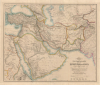
Map of the Counties Situated between the Rivers Nile and Indus; serving as an Inex to the work on the Expedition for hte Survey of the Euphrates and Tigris Drawn from Materials furinished by Lieut. Colonel Chesney R. S. F.R.S.
Best general mapping of Arabia in Persia - drawn from first hand reports and exploration.
- Digital Map Information
- Suitable for large format printing
- Full resolution TIFF file
- ICC color profile embedded
- Delivered instantly via download link
Best general mapping of Arabia in Persia - drawn from first hand reports and exploration.
This is a 1850 general map of Arabia and Persia, illustrating the route of Rawdon Chesney's Euphrates Expedition (1835 - 1837). Decades before the Suez Canal, Chesney proposed the Euphrates as a viable route for steamers to reach the Persian Gulf and, thus, India, avoiding the dangerous months-long voyage around Africa. The cartography presented is the most advanced general mapping of Arabia and Persia then available, being either directly derived from the 1830s Euphrates Expedition or collected from local sources en route.A Closer Look
Centered on the Persian Gulf, this map covers from the Black Sea to Yemen and from the Nile River to Bombay, thus encompassing all of Arabia, Persia (Iran), Turkey, Jordan, Syria, Palestine, Afghanistan, and parts of India and modern-day Pakistan. Throughout, the map features topographical and practical detail, revealing the course of rivers, sites of cities and caravan stops, and various overland routes. Within the Persian Gulf region, Abu Dhabi (Abbouthubbea), Bahrain (Bahreïn), and numerous other Sheikdoms are named. The coverage is intended to emphasize the practicality of using the Euphrates as a steam navigation route to India, thus avoiding the need to round Africa.The map further attempts to contextualize the achievements of the Euphrates Expedition both regionally and historically. Expedition routes are highlighted in blue, green, and orange, and set on equal terms beside the highlighted routes of the Campaign of Cyrus and the Retreat of the Ten Thousand, the Marches of Alexander the Great, and the Voyage of Nearchus - thus inviting comparison while also underscoring the 'epic' quality of Chesney's achievement.
Euphrates Expedition (1835 - 1837)
The Euphrates Expedition (1835 - 1837), commanded by the British officer Colonel Francis Rawdon Chesney, was among the 19th century's most ambitious scientific and imperial surveys. Sponsored by the British Government, the expedition's goal was to determine whether the Euphrates River could serve as a viable overland and riverine route between the Mediterranean and the Persian Gulf, thereby shortening communications and trade with British India decades before the Suez Canal. Chesney's party combined hydrographic surveying, astronomical observations, topographical mapping, geological and natural history research, and archaeological investigation on an unprecedented scale. Despite disease, extreme weather, difficult relations with local authorities and tribes, and the catastrophic loss of more than 20 expedition members and the steamboat Tigris in a violent storm on the Euphrates, the expedition successfully produced the first systematic modern survey of much of the Euphrates and Tigris river systems. Its observations substantially advanced European knowledge of Mesopotamia and eastern Anatolia while providing valuable insights into antiquities, peoples, and natural resources. Although the proposed commercial steam route ultimately proved impractical, Chesney's work became a landmark in Middle Eastern cartography, culminating in his monumental two-volume The Expedition for the Survey of the Rivers Euphrates and Tigris (1850).Publication History and Census
This is one of several maps produced to illustrate Francis Rawdon Chesney's Expedition for the Survey of the Rivers Euphrates and Tigris (1850). Both the work and the separate maps are of great rarity. The current example is from an edition deaccessioned from the Leeds University library and bears the Leeds collection stamp along the bottom border. We see just four examples of the separate map in OCLC and six examples of the complete work in its 1850 edition (there are numerous digital holdings and a widely circulated 1969 reprint).Cartographers
Francis Rawdon Chesney (March 16, 1789 - January 30, 1872) was a British general and explorer. Chesnew was born in Annalong, County Down, Ireland. His father, Alexander Chesney, served Francis Rawdon-Hastings (Lord Rawdon; 1754 - 1826) during the American Revolutionary War (1775 - 1783). Rawdon sponsored the younger Chesney for a cadetship at the Royal Military Academy, Woolwich, and in 1805, he was gazetted to the Royal Artillery. Chesney was stationed in the Middle East, where he rose to prominence, leading an inspection tour of Egypt and Syria. In 1830, he submitted a report on the feasibility of a Suez Canal - it was this report that proved the basis of Ferdinand Marie de Lesseps (1805 - 1894) plans for the Canal. Chesney was confident that the Euphrates was navigable by steamships and would provide an expeditious route to India that did not require rounding Africa. He persuaded Parliament to fund an expedition to this effect, which launched in 1835. Although suffering numerous setbacks, the Expedition was ultimately successful, reaching the Persian Gulf in June 1836, proving that the Euphrates was indeed steam-navigable. Back in England, he was awarded the Royal Geographical Society's Founder's Medal, promoted to Major, and received a commission to compose a detailed account of the Expedition, which was published in 1850 as The Expedition for the Survey of the Rivers Euphrates and Tigris. He served abroad once in 1843 in Hong Kong after the First Opium War (1839 - 1842), after which, in 1847, his period of service complete, he retired to Ireland. He twice returned to the Middle East to work on railway surveys, in 1856 and 1862, but the railway was never built. He died in Ireland in 1872. Further Details...
John Walker (1787 - April 19, 1873) was a British map seller, engraver, lithographer, hydrographer, geographer, draughtsman, and publisher active in London during the 19th century. Walker published both nautical charts and geographical maps. His nautical work is particularly distinguished as he was an official hydrographer for the British East India Company, a position, incidentally, also held by his father of the same name. Walker's maps, mostly published after 1827, were primarily produced with his brothers Charles Walker and Alexander Walker under the imprint J. and C. Walker. Among their joint projects are more than 200 maps for the influential Society for the Diffusion of Useful Knowledge Atlas (SDUK). In addition they published numerous charts for James Horsburgh and the British Admiralty Hydrographic Office, including Belcher's important map of Hong Kong and Carless' exploratory map of Karachi. The J. and C. Walker firm continued to publish after both Walkers died in the 1870s. Further Details...
Longman (fl. c. 1720 - present) is a long-lived and venerable British publishing firm initially founded in the 1720s by Thomas Longman (1699 - 1755). Longman was born in Bristol and in 1716 was apprenticed to John Osborn, a London printer and bookseller. Completing his apprenticeship, Longman requested and was granted Osborn's daughter's hand in marriage. Shortly afterward, Longman acquired the stock of Robinson Crusoe publisher William Taylor and, along with Osborn, established a printing office on Paternoster Row. The two published numerous works, including Samuel Johnson's Dictionary. Around the same time that Osborn retired, Thomas Longman's nephew, another Thomas Longman (1730 - 1797), joined the firm, which was subsequently renamed T. and T. Longman. On the death of the original Thomas Longman, the nephew took over the firm and eventually passed it on to his son, Thomas Norton Longman (1771 - 1842). Thomas Norton seemed to have had a passion for partnering and, over the years, added Owen Rees (1730 - 1797), Thomas Brown (c. 1777 - 1869), and three more mysterious partners, Hurst, Orme, and Green, to the corporation's partner list. For many years, the firm published as Longman, Hurst, Rees, Orme, Brown & Green. Thomas Norton eventually passed the firm to his own sons, Thomas and William, who, during their tenure, bought out most of the minor partners, renaming the firm Longmans, Green & Co. Later, Thomas Longman's son took full control of the firm, renaming it Longman. During World War II, most of their plates and stock were destroyed, but the company nonetheless survived and went public in 1948. Longman was eventually acquired by the media conglomerate Pearson and continues to publish as Pearson Longman. Further Details...
Condition
Very good. Light even toning. Laid down on original linen. Slight wear on old fold lines.
References
OCLC 1581843001.