
1968 Al-Bajuri Wall Map of Arabia, Pan-Arabism

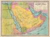
بلاد العرب / [Arab Lands].
Struggle for dominance in the Arab World.
Struggle for dominance in the Arab World.
This is an extremely rare c. 1968 Arabic-language wall map of the Arab Lands, prepared by one S.H.A., printed by Ahmed Al-Bajuri, and published by Mustafa Al-Babi Al-Halabi and Sons. It was produced during a period of upheaval and the independence of new nations, resulting in ephemeral and contested borders. While expressing a Nasser-style pan-Arabist perspective, it also evokes a standing struggle for cultural and political dominance over the Arab World.A Closer Look
The map covers from Egypt and Sudan in the west to Iran in the east, taking in the Arabian Peninsula. A legend below the title at top-right indicates symbols for settlements of different sizes as well as borders, maritime shipping lines, wells used by Bedouins, paved roads, unpaved roads, and oil fields. Major waterways (the Nile, the Suez Canal, the Tigris, and the Euphrates) are traced in black lines. Important early oil fields, such as Dhahran (الظهران) in Saudi Arabia and Burgan (برقان) in Kuwait, are indicated. Possible handwritten annotations note the location of the archaeological site of Mada'in Saleh (مَدَائِن صَالِح) or Hegra (الْحِجْر) in Saudi Arabia, the southernmost city of the Nabatean Kingdom and second largest after Petra.Very unusually for a map produced in the Arab world, particularly at the height of the pan-Arab movement, this map employs the phrase 'Persian Gulf' (خليج فارس) rather than the standard 'Arabian Gulf' (خليج عربي). The reason for this is unclear, as a map issued by a prominent map publisher in Cairo in the Nasser Era would have been sure to reflect pan-Arab ideology. However, it is possible that older lithographic printing plates from the 1930s or 1940s, when 'Persian Gulf' was common, were recycled for the production of this map. Similarly, Jordan is labeled named Transjordan (شرق الأردن) rather than the Hashemite Kingdom of Jordan (المملكة الأردنية الهاشمية), which it became in the late 1940s. The Emirates and Qatar are lumped together as the Trucial States (labeled the 'Emirates of the Oman Coast,' إمارات ساحل عمان).
The borders present are also curious, though more easily explained by the rapid changes underway with the independence of several countries and the unresolved state of some border disputes. For instance, a large neutral zone in southern Kuwait was the result of a decades-long dispute between Kuwait and the Sultanate of Nejd / Kingdom of Saudi Arabia, which was resolved in stages in the late 1960s by a partitioning of the zone. The border between Iraq and Saudi Arabia is very unusual here, in part because the modern, smooth border between the two countries had not yet been settled. The jagged border seen here also differs from other contemporary maps, with more numerous and dramatic 'kinks' than typical.
The 'Imamate of Oman'
Perhaps most unusually, the map presents Oman as divided between the Imamate of Oman (إمامة عمان) and the Nizwa of the Ibadis (نزوى الإباضية), with no mention of the Sultanate of Muscat and Oman, a reflection of Nasser's foreign policy. During the Jebel Akhdar War (1954 - 1959), the conservative interior of Oman (The Imamate) rebelled against the coastal Sultan of Muscat, who was heavily backed by the British military and oil interests. Because Egypt and Saudi Arabia opposed British colonial influence in the Gulf, Egypt officially recognized the Imamate of Oman as the legitimate, anti-imperialist government of the Omani interior. Even though the Sultan ultimately won the war and suppressed the Imamate (including Nizwa) by 1959 with British help, Egyptian educational maps throughout the 1960s continued to print the Imamate's name on maps to signal ideological solidarity and refuse recognition of British-backed borders.Historical Context
The map's title 'Bilād al-'Arab' (بلاد العرب) was a common phrase among pan-Arab nationalists, as in the movement's unofficial anthem 'The Arab Lands are My Homeland' (Bilād al-'Arab Awṭānī, بلاد العرب أوطاني). The 1950s and 1960s marked the peak of the modern Pan-Arab movement, an ideological surge dedicated to unifying the Arab world politically, culturally, and economically against Western imperialist influences. At the epicenter of this geopolitical wave was Egyptian President Gamal Abdel Nasser (in office 1954 - 1970), whose charismatic leadership and fierce anti-colonial rhetoric transformed Cairo into the undisputed capital of the Arab consciousness, as well as a node of global anti-imperialism and the Non-Aligned Movement. Nasser used Egypt's size and cultural export machinery, including radio broadcasts, literature, and educational curricula (including maps), to foster a shared identity that stretched across the Arab world.Nasser aimed to reshape the Middle East into a unified, anti-imperialist Arab bloc under Egyptian leadership. The high-water mark of this geopolitical vision came in 1958 with the creation of the United Arab Republic (UAR), a total political merger between Egypt and Syria meant to serve as the foundation for a sprawling pan-Arab superpower. Though the union collapsed by 1961 under the weight of Syrian resentment over Cairo's heavy-handed dominance, Nasser's regional influence remained immense. After the failure of the UAR, Nasser attempted to project Egyptian revolutionary ideals directly into the Arabian Peninsula, leading to a brutal quagmire in the North Yemen Civil War (1962 - 1967). Following a republican coup against the Zaydi Imamate in Sanaa, Nasser deployed over 70,000 Egyptian troops to prop up the young republic, turning Yemen into a bloody proxy battlefield against Saudi Arabia and Jordan, who backed the royalist guerrillas. Dubbed 'Egypt's Vietnam,' the grueling, five-year intervention bogged down Egyptian forces, drained the national treasury, and severely degraded military readiness. Nasser's aggressive regional brinkmanship backfired spectacularly in the disastrous 1967 Six-Day War. The swift, overwhelming defeat by Israel not only shattered Egypt's armed forces but dealt a devastating psychological blow to the entire pan-Arab project.
Publication History and Census
This map was drawn and drafted by a cartographer only known by the initials 'S.H.A.' and was 'executed' (printed) by Ahmed Al-Bajuri (أحمد الباجوري), about whom nothing is known but who presumably was a native of El Bagour (الباجور) in the Nile Delta in Northern Egypt. The map was published by Mustafa Al-Babi Al-Halabi and Sons (شركة مكتبة ومطبعة مصطفى البابي الحلبيوأولاده), a prominent publisher of the era based in Cairo (in another of the map's oddities, the publisher is located 'in Egypt' بمصر rather than the 'United Arab Republic' الجمهورية العربية المتحدة, Egypt's official name until 1971). The map is undated and assigning a date is complicated by the oddities and anachronisms mentioned above. It likely dates from the mid-late 1960s, based on the style of the map and some of the concrete political divisions present, particularly the Neutral Zone in southern Kuwait and the division of Yemen (the unified Aden Protectorate, which split into an eastern and western half in the late 1950s and early 1960s, is also likely anachronistic). The seeming unity of Qatar, the Emirates, and Bahrain also might suggest such a date, as there was an effort in 1968 - 69 to have Bahrain and Qatar join in a union with the coalescing Emirates. The Horn of Africa also provides helpful clues, as an independent Eritrea (supported by Nasser's Egypt) is indicated, while French Somaliland (الصومال الفرنسى), which became the French Territory of the Afars and the Issas (later Djibouti) in 1967, is maintained.This is an altogether unusual, enigmatic, and very rare map. We have been unable to locate any other examples in institutional collections or in market history.
Cartographer
Mustafa Al-Babi Al-Halabi Press (مطبعة مصطفى البابي الحلبي ; 1859 - c. 1985) was a prominent publisher based in Cairo. The firm was founded in Cairo in 1859 as the al-Maymaniyya Press (المطبعة الميمنية) by Ahmed al-Halabi (أحمد الحلبي ; d. 1898), an immigrant from Syria. As al-Halabi had no sons, he asked for his nephews to travel from his hometown of al-Bab, near Aleppo, to join him in the publishing business. When Ahmed al-Halabi died in 1898, he was succeeded by Mustafa Al-Babi Al-Halabi (مصطفى البابي الحلبي), presumably a nephew. The firm maintained the name al-Maymaniyya Press until 1919, when it was merged with Mustafa Al-Babi Al-Halabi's other publishing house, Dar Ihya' al-Kutub al-Arabiyya (دار إحياء الكتب العربية) which had been founded by by Isa al-Babi al-Halabi (عيسى البابي الحلبي). The new company was called Mustafa Al-Babi Al-Halabi and Sons Bookstore and Printing House (شركة مكتبة ومطبعة مصطفى البابي الحلبي وأولاده). The company was among the most prominent Egyptian publishers of the early-mid 20th century, specializing in religious works, such as al-Tabari's Qur'anic exegeses and Al-Ghazali's The Revival of Religious Sciences. Further Details...
Condition
Very good. Some light scuffing along original fold lines.