1859 Arrowsmith Map of Nunavut, Baffin's Bay, Search for Franklin Expedition Remains
ArcticShores-arrowsmith-1859$600.00

Title
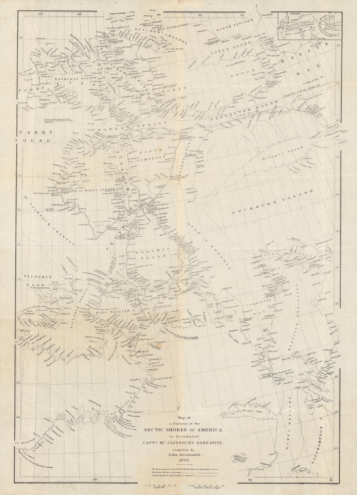
Map of a portion of the Arctic shores of America to accompany Captn. McClintock's narrative.
1859 (dated) 19.5 x 14 in (49.53 x 35.56 cm) 1 : 3000000
1859 (dated) 19.5 x 14 in (49.53 x 35.56 cm) 1 : 3000000
Description
An intricate map of the waters and islands of Nunavut in northeastern Canada, near Greenland, tracing the lost 'Franklin Expediton'. It was produced by John Arrowsmith in 1859 for Captain Francis McClintock's The Voyage of the 'Fox' in the Arctic Seas: A Narrative of the discovery of the fate of Sir John Franklin and his companions.
A Closer Look
Covering the northern portion of Nunavut, from Bathurst Island to Baffin's Bay in the north, and in the south from the border region between Nunavut and the Northwest Territories to Southampton Island, this map tracks the supposed route of the lost expedition of Sir John Franklin (1845 - 1848) as well as the route of McClintock's voyage a decade later. At top-right is an inset of Bellot Strait, which McClintock attempted to explore but decided against out of safety concerns. Islands, points, mountains, rivers, and other features are noted throughout.Context
McClintock's expedition took place in 1857. By this time, the Admiralty and the wider British public knew of the sad fate of Franklin's Expedition from several earlier relief expeditions, especially John Rae's 1853 - 1854 voyage. However, Rae's methods and conclusion were not widely accepted, in part because his Inuit informants suggested that the survivors of Franklin's crew had engaged in cannibalism before themselves starving to death. Thus, McClintock was dispatched with a small crew on a private voyage financed by Franklin's widow, Lady Jane Franklin, on July 1, 1857, to seek out evidence of the expedition's fate. Like Rea, McClintock benefitted greatly from information provided by the Inuit, who were able to direct them to a cairn, inside which was a message providing basic information on the desertion of Franklin's icebound ships and some of the subsequent difficulties encountered, including the death of Franklin himself. Though preceded by Rae, McClintock provided greater detail, especially on Franklin's own relatively early death, and was considered the true discoverer of the expedition's fate. Hailed as heroes, McClintock was knighted and his men rewarded for their efforts.Publication History and Census
This map was compiled by John Arrowsmith for Francis McClintock's The Voyage of the 'Fox' in the Arctic Seas: A Narrative of the discovery of the fate of Sir John Franklin and his companions. First published in 1859 by John Murray in London, the present map appeared in the first American edition, published in 1860 by Ticknor and Fields in Boston. The present map from the American edition is only independently cataloged by the Library and Archives Canada, while the map as it appeared in the first British edition is held by the University of Wisconsin - Madison, the University of Wisconsin - Milwaukee, the University of Michigan, Cornell University, and the Bayerische Staatsbibliothek. In either case, McClintock's entire work is more widely distributed in academic institutions.CartographerS
Aaron Arrowsmith (1750-1823), John Arrowsmith (1790-1873), and Samuel Arrowsmith. The Arrowsmith family were noted map engravers, publishers, geographers, and cartographers active in the late 18th and early 19th century. The Arrowsmith firm was founded by Aaron Arrowsmith, who was trained in surveying and engraving under John Cary and William Faden. Arrowsmith founded the Arrowsmith firm as a side business while employed by Cary. The firm specialized in large format individual issue maps containing the most up to date and sophisticated information available. Arrowsmith's work drew the attention of the Prince of Wales who, in 1810, named him Hydrographer to the Prince of Wales, and subsequently, in 1820, Hydrographer to the King. Aaron Arrowsmith was succeeded by two sons, Aaron and Samuel, who followed him in the map publication business. The Arrowsmith firm eventually fell to John Arrowsmith (1790-1873), nephew of the elder Aaron. John was a founding member of the Royal Geographical Society. The firm is best known for their phenomenal large format mappings of North America. Mount Arrowsmith, situated east of Port Alberni on Vancouver Island, British Columbia, is named for Aaron Arrowsmith and his nephew John Arrowsmith. More by this mapmaker...
The Old Corner Book Store (1828 - 1950) of 27-29 Bromfield Street is one of Boston's oldest and most historic locations. The structure that the Book Store occupied, still called the Old Corner Book Store, was originally built in 1712 as an apothecary shop. In 1828 Carter & Hendee took over the space and reinvented it as a bookshop. Later it fell into the hands of publishers Ticknor and James Fields. On November 12, 1864, shortly after Ticknor died, Fields sold the Old Corner Bookstore to E. P. Dutton. Dutton ran the business until his own retirement in 1869, when Alexander Williams took over the space, running it as A. Williams Publishers, Booksellers and Importers until his own retirement in 1883. In the 1890s it served as a magazine store. Such important literary giants as Henry Wadsworth Longfellow, James Russell Lowell, Henry David Thoreau, Ralph Waldo Emerson, Nathaniel Hawthorne, and Harriet Beecher Stowe were known to frequent the establishment. Due to its many literary connections, this shop published some of the most important American books ever written, including The Scarlet Letter, Walden, and the Atlantic Monthly Magazine. The space remained open as a bookstore for nearly 100 years before closing c. 1950. For a time it was converted to a parking garage until acquired by Historic Boston, Inc., who preserved it. Today the Globe Bookstore, in Harvard Square is considered its successor. The Old Corner Book Store building has been fully restored as a historic monument and is currently occupied by a jewelry store. Learn More...
John Murray I (1737 - 1793) founded the British publishing firm John Murray (1768 - present) in London. Born in Edinburgh, Murray served as an officer in the Royal Marines and built a list of authors that included Isaac D’Israeli and published the English Review. Murray the elder also was one of the founding sponsors of the London evening newspaper The Star in 1788. John Murray II (November 27 1778 - June 27, 1843) continued the family publishing business and developed it into one of the most important and influential publishing houses in Britain. The list of authors published by the firm grew to include Jane Austen, Sir Walter Scott, Washington Irving, George Crabbe, and Lord Byron under his tenure. Murray II also moved the business to 50 Albermarle Street in Mayfair, which became famous for Murray’s tradition of ‘four o’clock friends’, which was afternoon tea with his writers. John Murray III (1808 - 1892) continued to grow the business, and the firm published the first English translation of Goethe’s Theory of Colours, David Livingstone’s Missionary Travels and Charles Darwin’s Origin of Species during his tenure. Murray also published Herman Melville’s first two books. The firm began publishing Murray Handbooks in 1836, an ancestor of all modern travel guides. Sir John Murray IV (1851 - 1928) was publisher to Queen Victoria. Three successive Murray’s after Murray IV led the business until it was purchased by Hodder Headline in 2002, which was acquired by the French conglomerate Lagardère Group in 2004. Today, Murray is an imprint of Lagardère under the imprint Hachette UK. Learn More...
Source
McClintock, F.L., The Voyage of the 'Fox' in the Arctic Seas: A Narrative of the discovery of the fate of Sir John Franklin and his companions, (Boston: Ticknor and Fields) 1860.
Condition
Good. Small areas of soiling. Wear and light toning along fold lines.
References
OCLC 1007201173.