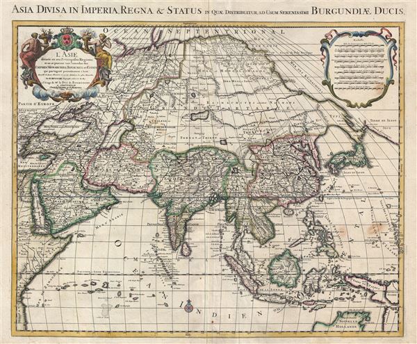
1730 Covens and Mortier (Delisle) Map of Asia
Asia-covensmortier-1730$950.00

Title
L' Asie divisee en ses principales regions, et ou se peuvent voir l'estendue des empires, monarchies, royaumes, et estats qui partagent presentement L'Asie / Asia divisa in imperia, regna & status in quae distributur.
1730 (undated) 19.5 x 23.5 in (49.53 x 59.69 cm) 1 : 22000000
1730 (undated) 19.5 x 23.5 in (49.53 x 59.69 cm) 1 : 22000000
Description
An attractive and large map of Asia issued by the Dutch firm of Covens and Mortier c. 1730. Covens and Mortier based this map upon an earlier map by Guillaume Delisle, which was in turn based upon the Sanson-Jaillot model of 1692. Presented on Sanson's Sinusoidal (a pseudocylindrical equal-area) projection, this map covers from the Aegean to Japan and from Nova Zembla to northern Australia. Oceanic depths are rendered with shading and topography is presented in profile.
This map is a fine illustration of just how little was known of Asia even in the early 18th century. Nonetheless, there is much here of interest. The Caspian Sea is wildly malformed, the Crimea is an island, mysterious uncertain lakes appear throughout Central Asia, the myth of Lake Chiamay is preserved in modern day Thailand, and northern Japan and northeast Siberia are entirely speculative.
This map is most striking for its speculative and barren illustration of Asia east of the Caspian Sea and north of India and China. At the time these lands were largely unknown and the cartographer is here assembling cities, mountains, rivers, and kingdoms primarily from second and third hand reports combined with mythology. One notes the Biblical kingdoms of Gog and Magog hidden behind a non-existent mountain range in northern Siberia. This is a reference to the writings of the Italian adventurer Marco Polo, who mentions these kingdoms in his journals. It was widely believed according to the Biblical book of Revelation that during the apocalypse the hordes of evil, Gog and Magog, would burst forth from behind this mountain range to terrorize the world.
The lands to the north and northwest of Japan bear some note. Here modern day Hokkaido, the southern parts of which are vaguely recognizable, is attached to the Yupi peninsula (Sakhalin). Beyond we can see several island territories including Terre de Etates, separated by the Detroit de Vries from Terre de Iesso, Ieco, or Terre de la Compagnie. Iesso or Ieco are typically terms associated with Hokkaido, but here the cartographer has moved the toponymy further east to the wildly oversized mapping of the Kuril Isalnds. The cartography here is a reference to the explorations of Dutchmen Maerten de Vries and Cornelis Jansz Coen. Searching for mythic islands of silver and gold (what's new?) the navigators stumbled upon the Japanese Kuril Islands. The smaller of these islands, modern day Kunashir, is presented with reasonable accuracy and here identified as Terre de Etates. The land to the east, thrice labeled Terre de Iesso, Ieco, or Terre de la Compagnie, is the island of Iturop, whose coast they did not explore but to which they nonetheless postulated fantastic size.
The reminder of the map follows the established convention of the period. The Indian subcontinent is notably narrow and Southeast Asia and the East Indies are remarkably well mapped. The northern shores of Australia as well as New Guinea are unknown and have boarders than fade into and out of one another. At the southern tip of the Malay Peninsula, Jahor is identified as Ihor.
This map was issued for the c. 1730 Covens and Mortier reissue of Delisle's Atlas Nouveau.
CartographerS
The De L'Isle family (fl. c. 1700 - c. 1760) (also written Delisle) were, in composite, a mapmaking tour de force who redefined early 18th century European cartography. Claude De L'Isle (1644 -1720), the family patriarch, was Paris based a historian and geographer under Nicholas Sanson. De L'Isle and his sons were proponents of the school of "positive geography" and were definitive figures, defining the heights of the Golden Age of French Cartography. Of his twelve sons, four, Guillaume (1675 - 1726), Simon Claude (1675 - 1726), Joseph Nicholas (1688 - 1768) and Louis (1720 - 1745), made a significant contributions to cartography. Without a doubt Guillaume was the most remarkable member of the family. It is said that Guillaume's skill as a cartographer was so prodigious that he drew his first map at just nine years of age. He was tutored by J. D. Cassini in astronomy, science, mathematics and cartography. By applying these diverse disciplines to the vast stores of information provided by 18th century navigators, Guillaume created the technique that came to be known as "scientific cartography", essentially an extension of Sanson's "positive geography". This revolutionary approach transformed the field of cartography and created a more accurate picture of the world. Among Guillaume's many firsts are the first naming of Texas, the first correct map of the Mississippi, the final rejection of the insular California fallacy, and the first identification of the correct longitudes of America. Stylistically De L'Isle also initiated important changes to the medium, eschewing the flamboyant Dutch style of the previous century in favor of a highly detailed yet still decorative approach that yielded map both beautiful and informative. Guillaume was elected to the French Academie Royale des Sciences at 27. Later, in 1718, he was also appointed "Premier Geographe du Roi", an office created especially for him. De L'Isle personally financed the publication of most of his maps, hoping to make heavy royalties on their sales. Unfortunately he met an untimely death in 1728, leaving considerable debt and an impoverished child and widow. De L'Isle's publishing firm was taken over by his assistant, Phillipe Buache who became, posthumously, his son in law. The other De L'Isle brothers, Joseph Nicholas and Louis De L'Isle, were employed in the Service of Peter the Great of Russia as astronomers and surveyors. They are responsible for cataloguing and compiling the data obtained from Russian expeditions in the Pacific and along the northwest coast of America, including the seminal explorations of Vitus Bering and Aleksei Chirikov. The De L'Isles, like their rivals the Vaugondys , must be considered speculative geographers. Speculative geography was a genre of mapmaking that evolved in Europe, particularly Paris, in the middle to late 18th century. Cartographers in this genre would fill in unknown areas on their maps with speculations based upon their vast knowledge of cartography, personal geographical theories, and often dubious primary source material gathered by explorers and navigators. This approach, which attempted to use the known to validate the unknown, naturally engendered many rivalries. The era of speculatively cartography effectively ended with the late 18th century explorations of Captain Cook, Jean Francois de Galaup de La Perouse, and George Vancouver. More by this mapmaker...
Covens and Mortier (1721 - c. 1862) was an Amsterdam publishing firm, the successor to the extensive publishing empire built by Pierre Mortier (1661 - 1711). Covens and Mortier maps are often criticized as derivative - but this is not fully the case. Pierre Mortier lived in Paris from 1681 to 1685. There he established close relationships the the greatest French cartographers of the era, including De L'Isle and D'Anville. His business model was based upon leveraging Dutch printing technology and sophistication to co-publish state of the art French cartography. Upon Mortier's death in 1711 his firm was taken over by his son, Cornelius Mortier (1699 - 1783). Cornelius married the sister of Johannes Covens (1697 - 1774) in 1721 and, partnering with his brother in law, established the Covens and Mortier firm. Under the Covens and Mortier imprint, Cornelius and Johannes continued in Pierre's model of publishing the most up-to-date French works with permission. They quickly became one of the largest and most prolific Dutch publishing concerns of the 18th century. The firm and its successors published thousands of maps over a 120 year period from 1721 to the mid-1800s. During their long lifespan the Covens and Mortier firm published as Covens and Mortier (1721 - 1778), J. Covens and Son (1778 - 94) and Mortier, Covens and Son (1794 - c. 1862). Learn More...
Source
De L'Isle, G., Atlas Nouveau, Contenant Toutes Les Parties Du Monde, Ou sont exactement Remarquées les Empires, Monarchies, Royaumes, Etats, Republiques &c. Par Guillaume de l'Isle. Premier Géographe de sa Majeste, (Amsterdam, Covens and Mortier) c. 1730.
Condition
Very good. Original centerfold. Blank on verso. Very minor discoloration near the Philippines.
References
OCLC 773174871.