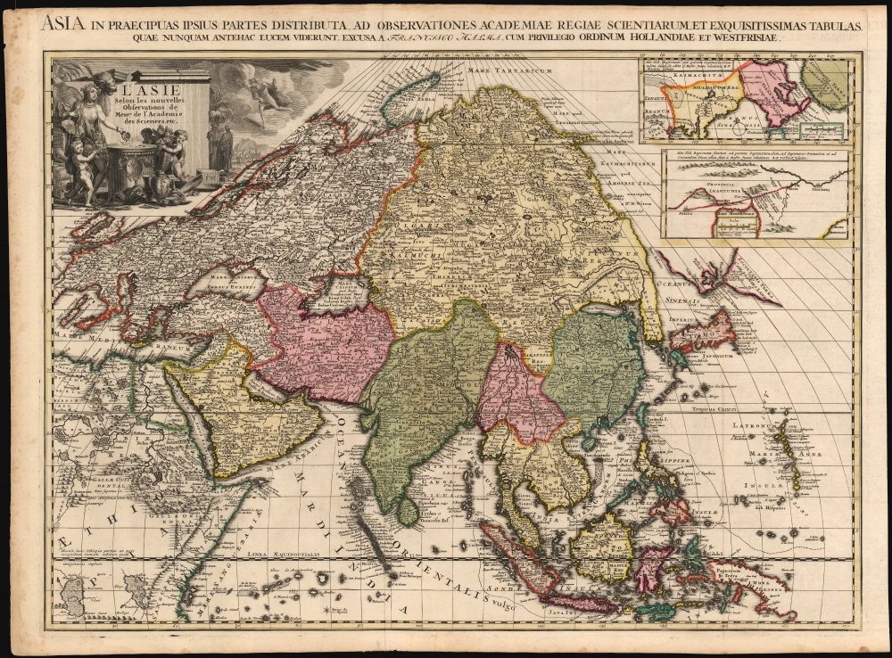
1700 François Halma Map of Asia
Asia-halma-1700$4,000.00

Title
L'Asie selon les nouvelles Observations de Messrs. de l'Académie Royale des Sciences, etc./ Asia in praecipuas ipsius partes distributa, ad observationes academiae regiae scientiarum, et exquisitissimas tabulas, quae nunquam antehac lucem viderunt, Excusa A Francisco Halma, cum privilegio ordinum Hollandiae et westfrisiae.
1700 (undated) 19.5 x 26 in (49.53 x 66.04 cm) 1 : 22000000
1700 (undated) 19.5 x 26 in (49.53 x 66.04 cm) 1 : 22000000
Description
This is the rare first state of François Halma's c. 1699 separately-issued map of Asia. Its unusually large folio size, bold and sophisticated engraving, and rich original color sets this map apart as one of the most beautiful late-seventeenth century maps of the continent. It dramatically presents some of the most notable geographic innovations of its era, including early theories of the nature of the strait separating Asia and America, the growing European understanding of Siberian geography, and developments in the continued European confusion regarding the nature of Korea, Japan, and the eastern coasts of Asia. Although not a focus, the map also shows a key development in the understanding of African geography: the placement of Lake Tana as the source of the Blue Nile, and the separation of the River Nile from Lakes Zaire and Zaflan - which since Ptolemy had been assumed to be the source of the great river.
Halma's Japan appears to draw partially from De Fer's toponomy - the place names 'Osacco,' 'Tanura,' and 'Yuoqui' appear on both maps. The shape of Japan here does not resemble De Fer's, however; it is possible that it may be a throwback to Blaeu's Japan, at least in terms of the eastern coastline. Taken as a whole, Halma's presentation of this area appears to be a unique amalgam of sources.
De Fer's Precedent
The overwhelming weight of Halma's geographical information is drawn from Nicolas De Fer's monumental Asie, divisee selon l'etendue de ses principales parties, a 1696 wall map of the continent engraved in Paris. De Fer's distinctive presentation of the Indian subcontinent, the Caspian Sea, and his reliance upon Nicolaes Witsen's groundbreaking Siberian geography are all presented here. The two inset maps in the upper right, showing alternative theories of northeast Chinese and Siberian geography are based on the Jesuit reports of Martini and Verbiest, are also derived (in reduced and simplified form) from the De Fer.Japan, Korea and the Company Islands
Halma diverges sharply from De Fer in his treatment of the Far East from the Equator to the 55th parallel north: Japan, Korea and the region later be identified as the Kuril Islands. The De Fer wall map shows a peninsular Korea, and extends the coastline from Korea sharply to the east-north-east, accompanied with the note that 'all this coast as well as Japan are drawn from Portuguese maps very different from ours.' De Fer's map shows a peculiarly elongated Japan with an island of 'Ieso' roughly corresponding with Hokkaido. Halma replaces all of this: in lieu of the long, speculative coastline with a tentative depiction of a Terra de Yesso, Staten Island (Kunashir), and Compagnies Land (Iturup). Yesso, here a proto-Sakhalin Island, was often shown as a peninsula attached to mainland Asia, but here is depicted as an incomplete island separated from Asia by a 'Fret. Esoni' (Strait of Yesso.) Yesso is separated from the inflated Compagnies Land by Staten Island, and the Strait of De Vries. The first inset in the upper right shows this same region, but depicting Yesso in its more conventional peninsular form. De Fer himself appears to have been uncertain enough of his own geography to provide the inset.Halma's Japan appears to draw partially from De Fer's toponomy - the place names 'Osacco,' 'Tanura,' and 'Yuoqui' appear on both maps. The shape of Japan here does not resemble De Fer's, however; it is possible that it may be a throwback to Blaeu's Japan, at least in terms of the eastern coastline. Taken as a whole, Halma's presentation of this area appears to be a unique amalgam of sources.
A State of the Art Siberia
The whole of the Asian Northeast -everything extending north and east from the Caspian Sea - is here derived from the 1690 map of Nicolaes Witsen, the first European with access to Russian sources for these remote regions. It is perhaps the paucity of data Witsen provides for the Pacific Coast south of the 50th parallel, that encourages the broad speculation on the present map.The Ptolemaic Lakes of Africa
Like most maps of the 17th century, the maps of the Sanson-Du Val lineage present the two great lakes of Zaire and Zaflan as the sources of the River Nile, a geographical assumption reaching back to Ptolemy. Pierre Du Val's 1678 4-sheet map of the continent is the first to diverge from this trope, showing instead Lake Tana as the source of the Blue Nile, and disassociating Lakes Zaire and Zaflan completely from the Nile. This correction was far from universally adopted by contemporaries. The handful who did included De Fer, whose 1696 wall map of Asia provided the basis for the bulk of the present map.A Magnificent Baroque Cartouche
The title cartouche is inscribed on a great stone wall, before which is an altar whereon a female representation of Asia pours incense on a burning offering, while a camel peers over her shoulder. Putti wrangle great bundles of spice to the altar. Painted jars and piles of silks. are strewn about; a crate bears Halma's 'FH' initials. Against a mountainous background a caravan can be dimly seen, whilst Hermes - the Greek god of communication, and commerce - hovers over all.Publication History and Census
The map was printed by François Halma, probably after 1699. It was masterfully composed by Jan Goeree, and superbly engraved by the unjustly obscure J. Baptiste. Halma produced no full-size atlas of his own, but this map was accompanied by similarly grand maps of Africa, America, and Europe, and likely Halma's 1696 north polar projection world after Cassini. Before 1713, the plates were acquired by Leiden map publisher Pieter van der Aa, who replaced Halma's imprints with his own and included the maps in his 1713 Le Nouveau Théâtre du Monde. Halma's separately issued maps, destined for decorative use or tipping into composite atlases by other publishers, have survived in only a few examples. We are aware of only one other example of this edition of this map coming to the market, and there is but a single example cataloged in OCLC, tipped into a Visscher atlas now held by the Newberry Library.CartographerS
François Halma (1653 - 1722) was a Dutch publisher active in Utrecht (starting 1674) and later in Amsterdam where he worked as printer and publisher from 1699-1710. He eventually settled at Leeuwarden, where he died. His output was composed of botanical, theological and historical works, but also, he published a small number of geographies and atlases. In 1695, he published an edition of Gerard Mercator's Ptolemy. His re-issue of Schotanus à Sterringa’s Friesche Atlas in 1698 was regarded among his finest work. He also published an edition of Sanson’s Description de l’Univers. He produced an edition of Falda's plan of Rome in or around 1700. He also caused to be engraved a set of large-format maps of the continents and the world (this latter after Cassini) which are quite rare and appear to have been separately issued. We are aware of institutional copies of the continents having been bound into a 1710 Visscher atlas. The execution of these large and rare maps, drawn by Jan Goeree and engraved by Jan Baptiste, was of a very high quality. The plates were later acquired and reprinted, virtually unchanged, by Pieter van der Aa in 1713. More by this mapmaker...
Jan Goeree (1670 - 1731) was a Dutch painter, draughtsman and printmaker. He was also known as a poet. He was the son of one Willem Goeree and no details come down to us of his youth in Middleburg. In Amsterdam he was a pupil of Dutch Golden Age painter and art theorist Gerard de Lairesse. He lived out his life in Amsterdam, the city in which most of his work was produced. His engraving appeared in De Fer's Atlas Royal. Tooley's Dictionary is probably mistaken in saying he worked for Pieter van der Aa. Although his imprint is to be found on van der Aa's large format maps, these were executed on behalf of François Halma as early as 1694, and the plates later acquired and reprinted by van der Aa in 1713. Learn More...
J. Baptist (active late 17th century) was an engraver active in the Netherlands in the latter part of the 17th century and possibly into the early 18th. We see his imprint virtually only in the work of François Halma (any connection with the later work of Pieter van der Aa is extremely tenuous; as the Aa plates attributed to Baptist were actually executed on behalf of Halma and later purchased by the Leiden publisher.) Learn More...
Nicholas de Fer (1646 - October 25, 1720) was a French cartographer and publisher, the son of cartographer Antoine de Fer. He apprenticed with the Paris engraver Louis Spirinx, producing his first map, of the Canal du Midi, at 23. When his father died in June of 1673 he took over the family engraving business and established himself on Quai de L'Horloge, Paris, as an engraver, cartographer, and map publisher. De Fer was a prolific cartographer with over 600 maps and atlases to his credit. De Fer's work, though replete with geographical errors, earned a large following because of its considerable decorative appeal. In the late 17th century, De Fer's fame culminated in his appointment as Geographe de le Dauphin, a position that offered him unprecedented access to the most up to date cartographic information. This was a partner position to another simultaneously held by the more scientific geographer Guillaume De L'Isle, Premier Geograph de Roi. Despite very different cartographic approaches, De L'Isle and De Fer seem to have stepped carefully around one another and were rarely publicly at odds. Upon his death of old age in 1720, Nicolas was succeeded by two of his sons-in-law, who also happened to be brothers, Guillaume Danet (who had married his daughter Marguerite-Geneviève De Fer), and Jacques-François Bénard (Besnard) Danet (husband of Marie-Anne De Fer), and their heirs, who continued to publish under the De Fer imprint until about 1760. It is of note that part of the De Fer legacy also passed to the engraver Remi Rircher, who married De Fer's third daughter, but Richer had little interest in the business and sold his share to the Danet brothers in 1721. Learn More...
Nicolaes Witsen (May 8, 1641 - August 10, 1717) was a Dutch cartographer, diplomat, writer, businessman, and politician. Witsen was born in Amsterdam to the politically powerful Cornelius Jan Witsen, burgomaster, head bailiff and administrator of the Dutch West India Company. Witsen studied Law at the University of Leiden where he developed an interest in language and maps. He was highly educated and traveled in elite circle, befriending Oliver Cromwell, Andrew Vinius, Cosimo III de'Medici, Melchisédech Thévenot, and others. In 1662 he presented a paper at the Amsterdam Athenaeum Illustre arguing for the effect of comets on earthly life. Witsen joined the VOC (Dutch East India Company) became an expert on shipbuilding, composing several treatises on the subject. His passion, however, remained cartography, particularly the cartography of Asia. Having traveled in embassy to Russia, Witsen contrived to get special access to Russian records on the exploration of Siberia, including the heretofore unknown explorations of Semyon Dezhnev. He also acquired the diary of Maarten Gerritsz Vries, who had explored the coast of Sakhalin in 1643. The Vries diary was thereafter lost. This information he compiled into several influential maps and books on Asia which were extensively copied. One result of this work is the Witsen Peninsula - a narrow outcropping of land extending from Siberia that appears on many maps of the early 17th century. Later, Witsen became Mayor of Amsterdam, a position he held some 13 times, and under whose tenure arts flourished. Witsen died in Amsterdam and was buried near his country home in Egmond aan den Hoef. Learn More...
Condition
Very good. Mend at bottom of centerfold, few marginal mends away from printed image, else excellent with a bold strike, attendant to the youth of the plate. Superb original color.
References
OCLC 925490997.