1816 Thomson Map of Alaska and the Bering Strait
AsiaAmerica-thomson-1816-2$300.00

Title
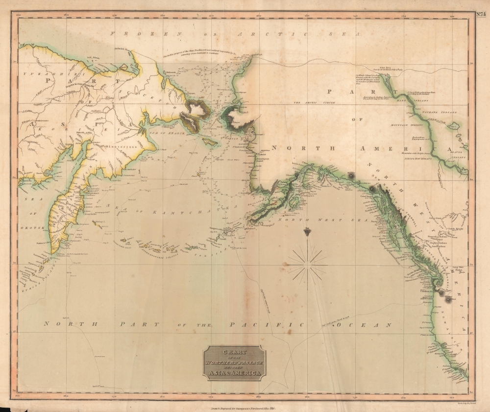
Chart of the Northern Passage Between Asia and America.
1816 (dated) 20 x 24 in (50.8 x 60.96 cm) 1 : 18000000
1816 (dated) 20 x 24 in (50.8 x 60.96 cm) 1 : 18000000
Description
This is John Thomson's 1816 map of the Bering Strait. It is one of the earliest atlas maps to give attention to the northern Alaskan coastline.
Around 71° N latitude, Thomson includes the note, 'The further progress of ships northward was rendered impossible by the ice extending from continent to continent.' Despite this, he maps a speculative northern Alaskan coastline connecting the Bering Strait to the northern sea discovered in 1789 by Alexander MacKenzie. He further maps the MacKenzie River, named after the erstwhile explorer, and indicates its course as far inland as Great Slave Lake. The establishment of an outpost on Whale Island, at the mouth of the MacKenzie River, is also noted.
Thomson's mapping of the speculative coastline between the Bering Strait and the Whale Island Post, taunts with the possibility of an Arctic trade route from the interior of British North America to the Pacific. Such a route would be highly profitable for the Hudson Bay Company, and its subsidiary Northwest Company, in transporting their beaver pelts to the lucrative markets in China.
Around the same time as this map was being published, an American outpost, named Fort Astoria, was established by John Jacob Astor's American Fur Company on the Columbia River. Though not named here, Fort Astoria was the first American outpost on the western coast of the continent and led to conflicts with Britain over territorial claims and trading rights in the region.
A Closer Look
Centered on the Bering Strait, Thomson's map covers from the coast of California to Alaska and the Arctic Sea, and the coast of Asia from the Kurile Islands and Kamchatka to Shelatskoi Noss and the Bear Islands. The Aleutian Islands, here identified as the Fox Islands, Andreanovskik Islands, and Aleoutskie Islands, are also included. Relief is shown by hachure, with towns, cities, and major topographical features identified.Historical Context
Thomson drew this map to illustrate the discoveries of Captain James Cook, with the tracks of his voyages evident throughout. In addition, the discoveries of other voyages by Bering, Perouse, and Vancouver are also clearly in evidence. These include Vancouver's remarkable mapping of the northwest coast between Washington and Alaska, and Bering's detailed mapping of Kamchatka and the Asian side of the Bering Strait.Around 71° N latitude, Thomson includes the note, 'The further progress of ships northward was rendered impossible by the ice extending from continent to continent.' Despite this, he maps a speculative northern Alaskan coastline connecting the Bering Strait to the northern sea discovered in 1789 by Alexander MacKenzie. He further maps the MacKenzie River, named after the erstwhile explorer, and indicates its course as far inland as Great Slave Lake. The establishment of an outpost on Whale Island, at the mouth of the MacKenzie River, is also noted.
Thomson's mapping of the speculative coastline between the Bering Strait and the Whale Island Post, taunts with the possibility of an Arctic trade route from the interior of British North America to the Pacific. Such a route would be highly profitable for the Hudson Bay Company, and its subsidiary Northwest Company, in transporting their beaver pelts to the lucrative markets in China.
Around the same time as this map was being published, an American outpost, named Fort Astoria, was established by John Jacob Astor's American Fur Company on the Columbia River. Though not named here, Fort Astoria was the first American outpost on the western coast of the continent and led to conflicts with Britain over territorial claims and trading rights in the region.
Publication History and Census
This map was prepared and engraved in 1816 in Edinburgh by Samuel John Neele for inclusion in the 1817 first edition of John Thomson's New General Atlas.CartographerS
John Thomson (1777 - c. 1841) was a Scottish cartographer, publisher, and bookbinder active in Edinburgh during the early part of the 19th century. Thomson apprenticed under Edinburgh bookbinder Robert Alison. After his apprenticeship, he briefly went into business with Abraham Thomson. Later, the two parted ways, John Thomson segueing into maps and Abraham Thomson taking over the bookbinding portion of the business. Thomson is generally one of the leading publishers in the Edinburgh school of cartography, which flourished from roughly 1800 to 1830. Thomson and his contemporaries (Pinkerton and Cary) redefined European cartography by abandoning typical 18th-century decorative elements such as elaborate title cartouches and fantastic beasts in favor of detail and accuracy. Thomson's principle works include Thomson's New General Atlas, published from 1814 to 1821, the New Classical and Historical Atlas of 1829, and his 1830 Atlas of Scotland. The Atlas of Scotland, a work of groundbreaking detail and dedication, would eventually bankrupt the Thomson firm in 1830, at which time their plates were sequestered by the court. The firm partially recovered in the subsequent year, allowing Thomson to reclaim his printing plates in 1831, but filed again for bankruptcy in 1835, at which time most of his printing plates were sold to A. K. Johnston and Company. There is some suggestion that he continued to work as a bookbinder until 1841. Today, Thomson maps are becoming increasingly rare as they are highly admired for their impressive size, vivid hand coloration, and superb detail. More by this mapmaker...
Samuel John Neele (July 29, 1758 - May 13, 1824) was a prolific British map engraver active in the late 18th and early 19th centuries. Neele apprenticed as a printer and engraver with Harry Ashby from about 1781 to 1782 before establishing himself independently in 1785 at 352 Strand, London. The combination of business acumen and technical skill made Neele extremely successful with literally hundreds of maps to his credit. His vast corpus was composed of notable maps by most major English publishers of the period including, Haywood, Faden, Wallis, Stockdale, Arrowsmith, Thomson, Pinkerton, and Greenwood, among others. Neele's sons, James and Josiah Neele, also engravers, took over their fathers business around 1818, both becoming notable in their own right. Learn More...
Source
Thomson, J., A New General Atlas, (Edinburgh: Baldwin, Cradock, Joy) 1817.
Thomson's New General Atlas was first published in 1817 and continued to be published until about 1821. This is the first of Thomson's major cartographic works and the atlas for which is most celebrated. The New General Atlas follows in the Edinburgh School, which eschews excessive decoration in favor of a more minimalistic fact-based cartographic vision, as established by John Pinkerton, Laurie and Whittle, John Cary, and others in the previous decades. The maps are notable for their massive scale, heavy stock, elegant color work, and easy-to-read typefaces. Although the atlas stopped being published after 1821, Thomson continued to offer 'supplementary' maps that could be tipped into the atlas as late as 1830, when he declared bankruptcy. The maps in the Thomson Atlas were engraved by Thomas Clerk, William Dassauville, Nathaniel Rogers Hewitt, James Kirkwood, Robert Kirkwood, John Menzies, George Menzies, Edward Mitchell, John Moffatt, Samuel John Neele, Robert Scott, and James Wyld.
Condition
Average. Original centerfold exhibits moderate toning. Some offsetting. Creasing.
References
Phillips (Atlases) 731. Newberry Library: Ayer 135 T4 1817. Rumsey 1007.080.