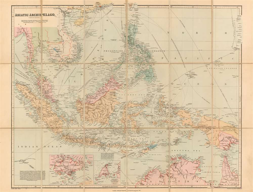
1906 Stanford Issue of John Arrowsmith's Map of Southeast Asia and the East Indies
AsiaticArchipelago-arrowsmith-1906$850.00

Title
Asiatic Archipelago on Mercator's Projection.
1906 (undated) 19.75 x 24.5 in (50.165 x 62.23 cm) 1 : 10000000
1906 (undated) 19.75 x 24.5 in (50.165 x 62.23 cm) 1 : 10000000
Description
This is John Arrowsmith's map of Southeast Asia and the East Indies in an updated c. 1906 issue published by Stanford. This map achieved astonishing longevity via frequent updates, having first appeared in 1832.
A Closer Look
Though it retains Arrowsmith's notations - for example, pointing out the best seasonal routes to China and describing the catastrophic 1815 volcanic eruption of Mount Tambora - the map would be amended as early as 1848. From its earliest inception, the map included the inset of Singapore Island. An additional inset featuring Labúan Island (surveyed by Captain Sir Edward Belcher and Lieut. D. M. Gordon) appears on examples of the map as early as 1848 - an impressively up-to-the-minute change, as the survey in question was not published by the Admiralty until 1847. Hong Kong is outlined in red. The French and British spheres of influence near Siam are also outlined in red, roughly conforming to the treaties between France and Siam following their 1893 war. Guam's spelling has been altered from the earlier 'Guahan,' and its association with the United States is noted. New Guinea (completely undefined in Arrowsmith's first iteration of the map) has had its coastline completed and its interior mapped. Its borders reflect the division of the island between the Netherlands, Great Britain, and Germany between 1884 and 1919, with German New Guinea named 'Kaiser Wilhelm Land.' Throughout the map's publication, the interiors of Borneo, Singapore, and Australia were completely reworked.Railways
Railways are traced in Burma, Siam, French Indochina, Java, the Philippines, and Australia. The North Australian Railway can be seen at its extent in about 1889; it does not yet (as it would in 1917) reach the Katherine River. The map shows the Singapore-Kranji Railway bisecting Singapore Island; this railway was completed in 1903, as was the line in British North Borneo from Beaufort to Jesselton. A further extension of this railway from Beaufort to Tenom was completed in 1906; this branch appears on the map.Publication History and Census
John Arrowsmith first published this map in 1832; it would remain in publication, assiduously updated and amended, apparently for over a century (OCLC shows a 1936 example). The extent of the railways in British North Borneo suggests an early date of 1906 for the map. The colonial borders in New Guinea would tend to indicate a date no later than 1918.CartographerS
Aaron Arrowsmith (1750-1823), John Arrowsmith (1790-1873), and Samuel Arrowsmith. The Arrowsmith family were noted map engravers, publishers, geographers, and cartographers active in the late 18th and early 19th century. The Arrowsmith firm was founded by Aaron Arrowsmith, who was trained in surveying and engraving under John Cary and William Faden. Arrowsmith founded the Arrowsmith firm as a side business while employed by Cary. The firm specialized in large format individual issue maps containing the most up to date and sophisticated information available. Arrowsmith's work drew the attention of the Prince of Wales who, in 1810, named him Hydrographer to the Prince of Wales, and subsequently, in 1820, Hydrographer to the King. Aaron Arrowsmith was succeeded by two sons, Aaron and Samuel, who followed him in the map publication business. The Arrowsmith firm eventually fell to John Arrowsmith (1790-1873), nephew of the elder Aaron. John was a founding member of the Royal Geographical Society. The firm is best known for their phenomenal large format mappings of North America. Mount Arrowsmith, situated east of Port Alberni on Vancouver Island, British Columbia, is named for Aaron Arrowsmith and his nephew John Arrowsmith. More by this mapmaker...
Edward Stanford (May 27, 1827 - November 3, 1904) was one of the most prolific map publishing firms of the late 19th century. The company began as a partnership in 1848 between the 21 year old Edward Stanford and the established map dealer Trelawney Saunders. By 1853 the partnership had dissolved and Edward Stanford took full control of the business. A subsequent series of expansions and exciting new map issues finally led to the production of Stanford's masterwork, "Stanford's Library Map of London". This map is still available and remains somewhat accurate. At the time of publishing it was hailed by the Royal Geographical Society as "the most perfect map of London that has ever been issued". In 1882 Edward Stanford Sr. passed the firm on to his son, Edward Stanford Jr. who continued in his father's proud tradition. Today the Stanford firm still publishes maps and remains one of the most important and prolific cartographic publishers in the world. Learn More...
Condition
Very good. Dissected and mounted on linen as issued. Boards removed but present.
References
OCLC 947046833.