
This item below is out of stock, but another example (left) is available. To view the available item, click "Details."
Details
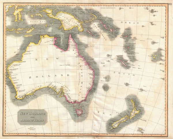
1814 Thomson Map of Australia, New Zealand and New Guinea
1814 (dated) $650.00
1814 Thomson Map of Australia, New Zealand and New Guinea
Australia-thomson-1814$350.00

Title
New Holland and Asiatic Isles.
1814 (dated) 20 x 25 in (50.8 x 63.5 cm)
1814 (dated) 20 x 25 in (50.8 x 63.5 cm)
Description
This a wonderful example of John Thompson's 1814 Map of Australia, New Zealand, New Guinea and parts of Polynesia. Extends from Western Australia and the Celebes eastward as far as New Caledonia and the Fiji Islands. Extends southward as far as New Zealand and Chatham Island. Notes the discoveries of important explorers in the region including Captain Grant, Captain Bandin, Captain Cook, Captain Flinders, Captain Bass, Captain Dampier, and others. Make notes on terrain, soil, water sources, and safe ports. This map was prepared around the same time that Captain Flinders published the first accurate map of the Australian coast. Slightly crisper impression in the south eastern portions of Australia, suggests several updates based upon Flinders' work. Prepared in 1814 by John Thomson for publication by Baldwin & Cradock as plate no. 73 in the 1817 edition of Thomson's New General Atlas.
CartographerS
John Thomson (1777 - c. 1841) was a Scottish cartographer, publisher, and bookbinder active in Edinburgh during the early part of the 19th century. Thomson apprenticed under Edinburgh bookbinder Robert Alison. After his apprenticeship, he briefly went into business with Abraham Thomson. Later, the two parted ways, John Thomson segueing into maps and Abraham Thomson taking over the bookbinding portion of the business. Thomson is generally one of the leading publishers in the Edinburgh school of cartography, which flourished from roughly 1800 to 1830. Thomson and his contemporaries (Pinkerton and Cary) redefined European cartography by abandoning typical 18th-century decorative elements such as elaborate title cartouches and fantastic beasts in favor of detail and accuracy. Thomson's principle works include Thomson's New General Atlas, published from 1814 to 1821, the New Classical and Historical Atlas of 1829, and his 1830 Atlas of Scotland. The Atlas of Scotland, a work of groundbreaking detail and dedication, would eventually bankrupt the Thomson firm in 1830, at which time their plates were sequestered by the court. The firm partially recovered in the subsequent year, allowing Thomson to reclaim his printing plates in 1831, but filed again for bankruptcy in 1835, at which time most of his printing plates were sold to A. K. Johnston and Company. There is some suggestion that he continued to work as a bookbinder until 1841. Today, Thomson maps are becoming increasingly rare as they are highly admired for their impressive size, vivid hand coloration, and superb detail. More by this mapmaker...
Baldwin and Cradock (fl. c. 1810 - 1860) were London based publishers working in the early to mid 19th century. They are best known for their publication of the Society for the Diffusion of Useful Knowledge's ground breaking subscription atlas. They also published John Thomson's magnificent New General Atlas from 1814 - c. 1820. In addition to their cartographic corpus, the firm had wide ranging publishing interests in many other areas, including books, broadsides, and an investment in Blackwoods Magazine. They had their offices at 47 Paternoster Row, London, England. This firm also published under the imprint Baldwin, Cradock, and Joy and Cradock and Joy. Learn More...
Source
Thomson, John, A new general atlas, consisting of a series of geographical designs, on various projections, exhibiting the form and component parts of the globe; and a collection of maps and charts, delineating the natural and political divisions of the empires, kingdoms, and states in the World. Constructed from the best systematic works, and the most authentic voyages and travels. With a memoir of the progress of geography, a summary of physical geography, and a consulting index to facilitate the finding out of places. Edinburgh: Printed by George Ramsay and Company, for John Thomson and Company, Edinburgh; Baldwin, Cradock, and Joy, London; and John Cumming, Dublin. 1817. (1817 edition)
Condition
Good condition. Minor creasing on and near the original centerfold. A couple of minor verso repairs to margins.
References
Rumsey 1007.079. Tooley, R.V., Mapping of Australia and Antarctica, p. 156, 1256. Phillips (Atlases) 731. Newberry Library: Ayer +135 T4 1817. National Library of Australia, MAP F 848.