1859 Johnston / Stanford Library Map of Australia and New Zealand
AustraliaLibrary-stanford-1859$8,500.00


Title
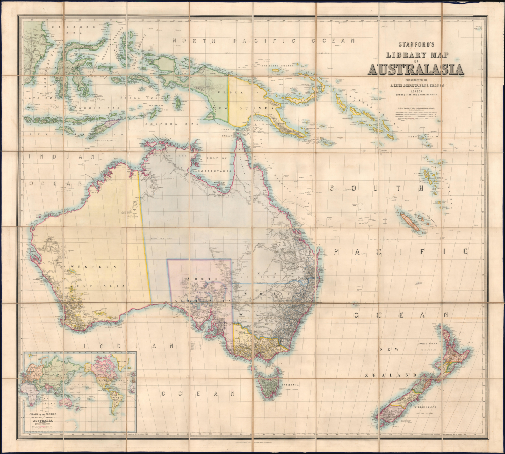
Stanford's Library Map of Australasia.
1859 (dated) 61.5 x 68 in (156.21 x 172.72 cm) 1 : 4089064
1859 (dated) 61.5 x 68 in (156.21 x 172.72 cm) 1 : 4089064
Description
The astounding 1859 first edition of A. Kieth Johnston and Edward Stanford's large-format Library Map of Australasia, comprising Australia, New Zealand, and New Guinea. This is arguably the largest and most detailed general map of Australia to appear in the 19th century, issued a month before the official establishment of Queensland in June 1859.
The map is justifiably praised and described in great detail in the September 15, 1859 issue of the Australian Mail,
A Closer Look
Coverage embraces Australasia from Borneo to New Zealand, including Australia, New Zealand, the Solomon Island, the New Hebrides, and New Caledonia. Within Australia, the map recognizes five distinct states - New South Wales has a northern border separating it from Queensland, though the latter is not yet recognized as a fully separate state. New Zealand is divided into 8 administrative regions over two islands.The map is justifiably praised and described in great detail in the September 15, 1859 issue of the Australian Mail,
A bad map exhausts the patience both of the student and the man of business. It is dear at any price, however low. On the other hand, it is a real pleasure to study a good, bold, well-executed map, brought up to the latest date. Mr. Stanford's new Library Map of Australasia fulfills every requirement. It is quite a work of art. Engraved in the finest style on copper plates, upon the large scale of 64 miles to an inch, which brings the entire size of the Map to 65 inches by 58, it is worthy of a place in any nobleman's library.
It forms the second of a series of large library maps, delineating the great terrestrial divisions of the globe. The Map of Europe was the first; the Map of Australasia is the second; Asia, Africa, North America, and South America will follow. Instead of giving Australasia as an appendage to the Asiatic continent, the publisher recognizes the great and growing importance of the English colonies, by giving them a special map. He is fully justified in claiming admiration of the work. Theinsertion of several new and important surveys and discoveries, never before published together; the introduction of new administrative boundaries; the boldness and perspicacity as well as the precision of the delineation and names; the distinctive colouring; and the comprehensive scope of the Map,form only a few of its meritorious features.
The manner in which Mr. A.K. Johnston has performed his task is deserving of the highest praise. To prove that the work has been brought down to the latest date, it may be mentioned that the lately-formed province of Hawke Bay, in New Zealand, is distinctively marked; not so, however, Queensland, to the north of New South Wales, the boundaries being yet undetermined. The remarkable additions made to Australasian geography by exploring parties and new surveys are fully given. The explorations of Mr. McDougal Stuart, far beyond the Gawler Ranges, in South Australia; those of Mr. Herschel Babbage and Mr. Augustus Gregory, the latter of whom made the first overland journey from Moreton Bay to Adelaide; the researches of Captain Sturt from the South and of Mr. Kennedy from the NorthEast, together with those of Mr. F. T. Gregory in Western Australia; and the investigations in Northern Australia by eight or nine different explorers, - all receive due notice. It is justly remarked thatthe vast extent of unexplored country forming the northern and central parts of Australia must derive fresh interest from these successes, as they prove that the blank spaces on the Map, instead of being wholly desert, may include an abundance of valuable territory, and still hold out rich rewards to colonial enterprise.The last surveys in New Zealand are likewise embodied. Embraced within the extended scope of the Map are - in addition to Tasmania and New Zealand - Norfolk Island, 'once a pest-house of crime, but now a thriving settlement,' the French settlement of New Caledonia, New Guinea, and a large portion of the Asiatic Archipelago. (Australian Mail, 15/9/1859)
Publication History and Census
This map is the second in Stanford's 'Library Map' series, which includes all five continents. The present example is the first edition. We see subsequent editions as late as 1925. As a luxury item intended for governments, institutions, and people of wealth, production numbers were extremely low, and all maps from the 'Library' series are today extremely rare, especially as here, in the first edition. Over all editions, we see about 20 examples in OCLC, with only 3 being confirmed first editions.CartographerS
Alexander Keith Johnston (December 28, 1804 - July 9, 1871) was a Scottish cartographer and map publisher active in the middle portion of the 19th century. Johnson was born at Kirkhill, near Edinburgh, Scotland. He studied at the University of Edinburgh where he apprenticed as an engraver. Around 1826, in partnership with his brother William, he founded a cartographic printing and engraving firm with the imprint "W. and A. K. Johnston." Johnston made a name for himself in educational geography, publishing numerous maps for use in schools. His brother, William Johnston, eventually left the firm to pursue a career in politics, eventually becoming the Lord Provost of Edinburgh. Alexander's son, who would bear the same name, became a geographer and explorer, suffering an untimely death on the Royal Geographical Society's 1879 expedition to Lake Nyasa. More by this mapmaker...
Edward Stanford (May 27, 1827 - November 3, 1904) was one of the most prolific map publishing firms of the late 19th century. The company began as a partnership in 1848 between the 21 year old Edward Stanford and the established map dealer Trelawney Saunders. By 1853 the partnership had dissolved and Edward Stanford took full control of the business. A subsequent series of expansions and exciting new map issues finally led to the production of Stanford's masterwork, "Stanford's Library Map of London". This map is still available and remains somewhat accurate. At the time of publishing it was hailed by the Royal Geographical Society as "the most perfect map of London that has ever been issued". In 1882 Edward Stanford Sr. passed the firm on to his son, Edward Stanford Jr. who continued in his father's proud tradition. Today the Stanford firm still publishes maps and remains one of the most important and prolific cartographic publishers in the world. Learn More...
Condition
Very good. Original binding.
References
OCLC 223050551. Rumsey 15896.007. National Library of Australia, R. V. Tooley Map Collection, Tooley, 1187.