This item has been sold, but you can get on the Waitlist to be notified if another example becomes available, or purchase a digital scan.
1818 Pinkerton Map of Australia and New Zealand
AustraliaNewZealand-pinkerton-1818$350.00

Title
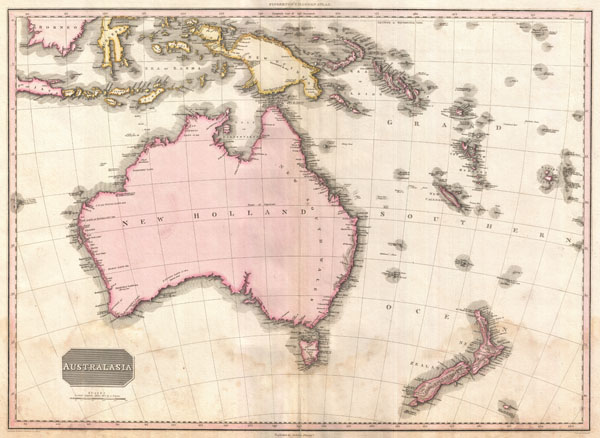
Australasia.
1818 (undated) 20.5 x 27.5 in (52.07 x 69.85 cm)
1818 (undated) 20.5 x 27.5 in (52.07 x 69.85 cm)
Description
Truly a masterwork of copperplate engraving, this is Pinkerton's extraordinary 1818 map of Australia, New Zealand and parts of the East Indies and Polynesia. Covers from Borneo south past Australia as far as Tasmania, and New Zealand. Pinkerton offers detail as he is able, but in 1808, when this map was being composed, this part of the world remained for the most part unexplored. New Guinea, New Zealand and Australia, had, around this time, been mapped only tentatively and then only their coastlines. In Southern Australia and New Guinea, even this was vague, as Pinkerton notes along the coast, 'Very Imperfectly Known.' Only two significant islands are shown for New Zealand with Rakiura Island attached to the mainland. All around Australia, Pinkerton offers copious notations regarding the activities of various exploring missions to the region, including P. Nuyt, Dinnings, Edels, C. F. De Witt, Esdracht, Dampier, Van Diemen, and others. In Polynesia the New Hebrides, New Caledonia, Fiji , Queen Charlottes Archipelago, and the Solomon Islands are identified. For the most part, the interiors of all the lands herein depicted are unknown and consequently left blank. Possibly the finest mapping of the region to appear in the first years 19th century.
Drawn by L. Herbert and engraved by Samuel Neele under the direction of John Pinkerton. This map comes from the scarce American edition of Pinkerton's Modern Atlas, published by Thomas Dobson & Co. of Philadelphia in 1818.
Drawn by L. Herbert and engraved by Samuel Neele under the direction of John Pinkerton. This map comes from the scarce American edition of Pinkerton's Modern Atlas, published by Thomas Dobson & Co. of Philadelphia in 1818.
CartographerS
John Pinkerton (February 17, 1758 - March 10, 1826) was an Scottish writer, historian, and cartographer. Pinkerton was born in Edinburgh, Scotland. He was a studious youth with a passion for the classics. As a young man, he studied at Edinburgh University before apprenticing as a lawyer. Around this time, he began writing, with his first book, Elegy on Craigmillar Castle published in 1776. Pinkerton moved to London in 1781 to pursue his writing career in earnest. He successfully published several works of literature, poetry, and history. Pinkerton proved passionate in his literary and historical writings, but his correspondence with other cartographers has been labeled as aggressive, even insane. In addition to his work as a writer and historian, Pinkerton was one of the leading masters of the Edinburgh school of cartography which flourished from roughly 1800 to 1830. Pinkerton and his contemporaries (Thomson and Cary) redefined European cartography by abandoning typical 18th century decorative elements such as elaborate title cartouches and fantastical beasts in favor of detail and accuracy. Pinkerton's principle work is Pinkerton's Modern Atlas published from 1808 through 1815 with a special American reissue by Dobson and Co. in 1818. Pinkerton relocated to Paris in 1818, where he managed his publishing business until his death in 1826. More by this mapmaker...
Thomas Dobson (1751 - 1823) was an American publisher active in Philadelphia during the late 18th and early 19th centuries. Dobson was born in Edinburgh, Scotland in 1751 and emigrated to Philadelphia c. 1780. In Philadelphia, he established a successful printing business by republishing edited and updated versions of important British reference materials in matching quality but at a much lower price point. He is best known for publishing the first American edition of the Encyclopedia Britannica. He also published America's first Hebrew Bible. Cartographically Dobson's most notable work is 1818 republication of Pinkerton's fantastic Modern Atlas. Learn More...
Source
Pinkerton, J., A Modern Atlas, from the Lates and Best Authorities, Exhibiting the Various Divisions of the World with its chief Empires, Kingdoms, and States; in Sixty Maps, carefully reduced from the Larges and Most Authentic Sources. 1818, Philadelphia, Thomas Dobson Edition.
Condition
Very good condition. Light spotting in lower quadrants. Blank on verso. Platemark visible.
References
Rumsey 0732.040. Phillips (Atlases) 724. National Maritime Museum, 409.