1791 Depot de la Marine Nautical Map of the Azores w/ Coastal Views
Azores-depot-1791$1,200.00


Title
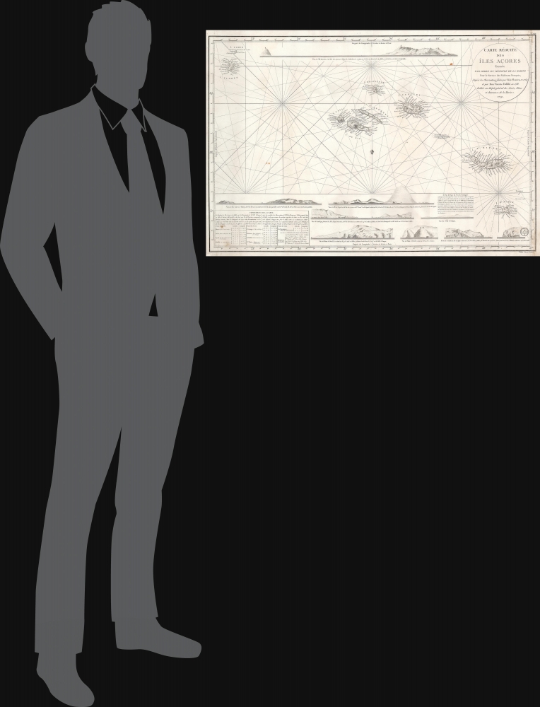
Carte Réduite des Îles Açores dressée Par Ordre du Ministre de la Marine Pour le Service des Vaisseux Français, d'après les Observations faites par M. de Fleurieu, en 1769 et par Don Vicente Tofiño en 1788. / Publiée au Dépôt général des Cartes, Plans et Journaux de la Marine. 1791.
1791 (dated) 22.25 x 33.25 in (56.515 x 84.455 cm) 1 : 750000
1791 (dated) 22.25 x 33.25 in (56.515 x 84.455 cm) 1 : 750000
Description
This elegant, separately-issued, Depot de la Marine nautical chart / map of the Azores is the first to employ modern nautical surveys using marine chronometers. This chart combines the data of the French hydrographer Charles Pierre Claret, Comte de Fleurieu (1738 - 1810), with that of the Spanish hydrographer Vincente Tofiño de San Miguel (1732 - 1795), whose respective surveys represented the first scientific charting of the Azores. It represents a vast improvement over the 1755 Bellin Carte Réduite des Îles Açores, which, until 1791, was the best French charting of the islands.
Claret de Fleurieu's contributions to the map are dated 1769, when he was in command of the frigate Isis, engaged in testing the new secret marine chronometers produced by Ferdinand Berthoud. The chronometers were employed throughout the voyage, which set out from Rochefort in 1768 and made for Santo Domingo by way of the Azores. The measurements taken off the Azores during this period represent the first scientific charting of those islands using modern instrumentation (and proved the efficacy of the French marine chronometers in navigating the transatlantic crossing). Claret de Fleurieu's observations do not appear to have been committed to any prior chart, though they were published in the 1773 Voyage fait par ordre du roi, pour éprouver les horloges marines in which the successful tests of the Berthoud chronometers were reported. The French data has been applied to the more recent Spanish chart, and used to confirm the accuracy of both, as is explained in the chart's text (here translated from the French):
The Chart's Sources
The main source for topography and toponymy is Vincente Tofiño de San Miguel's 1788 Carta esferica de las Islas de los Azores o Terceras. A bank between the islands of Tercera and St. Michael has been added, as well as a small island southeast of the Formigues islands spotted by French mariners in 1788. This chart employs rhumb lines where the Tofiño uses latitude and longitude. The most significant visual difference between the Tofiño and the Depot are the latter chart's nine beautifully engraved coastal views. These all are far superior to those found on the 1755 Bellin and show the benefit of a more recent survey.Claret de Fleurieu's contributions to the map are dated 1769, when he was in command of the frigate Isis, engaged in testing the new secret marine chronometers produced by Ferdinand Berthoud. The chronometers were employed throughout the voyage, which set out from Rochefort in 1768 and made for Santo Domingo by way of the Azores. The measurements taken off the Azores during this period represent the first scientific charting of those islands using modern instrumentation (and proved the efficacy of the French marine chronometers in navigating the transatlantic crossing). Claret de Fleurieu's observations do not appear to have been committed to any prior chart, though they were published in the 1773 Voyage fait par ordre du roi, pour éprouver les horloges marines in which the successful tests of the Berthoud chronometers were reported. The French data has been applied to the more recent Spanish chart, and used to confirm the accuracy of both, as is explained in the chart's text (here translated from the French):
The slight difference, or rather the agreement, which is found between the results of the observations of M. de Fleurieu and M. Tofino, reported in the table below, assures the position of all these islands with respect to Angra. We have taken the middle between these results to establish their longitude on the map: we have adopted the latitudes given by M. Tofino, and the configuration, as well as the understanding of the islands, has been taken from the map that he has published.
Publication History and Census
We have identified seven examples of this chart in institutional collections. We are not aware of any further issues or state changes.CartographerS
Vincente Tofiño de San Miguel (September 6, 1732 - 1795) was a Spanish naval officer and hydrographer active in the second half of the 18th century. Tofiño was born in Cadiz, Spain. His father, a career army officer, died in the 1746 Battle of Placentia, leaving Vincente an orphan from age 14. He moved to Extremadura where his uncle, a priest, raised him. In 1750, following in his father's footsteps, he joined the army. Having discovered a proficiency in mathematics, Tofiño was assigned to an artillery unit. In 1755, moving from the army to the navy, where his skills were better suited, he became a professor of mathematics at the Academia de Guardia Marinas de Cádiz. He would remain in the navy for the subsequent 30 years, ultimately attaining the rank of Rear Admiral. Between 1783 and 1788, as a navy officer, astronomer, and hydrographer, he was deployed to survey the Mediterranean ports of Spain, the Balearic Islands, and the Barbary Coast. He trained the explorers Dionisio Alcalá Galiano and Cayetano Valdés y Flores Bazán, who named Tofino Inlet, in Vancouver, after him. Tofiño was elected correspondent of the Spanish Academy of History and of the French and Portuguese Academies of Science. He died in Cadiz in 1795. More by this mapmaker...
Charles Pierre Claret, Comte de Fleurieu (July 2, 1738 - August 18, 1810) was a French explorer, and hydrographer. He served in the French Navy from the age of 13, campaigned in the Seven Years' War, and quickly became regarded an officer of distinction and intelligence. By 1765 he was engaged under Ferdinand Berthoud in the French efforts to produce a marine chronometer, the great 18th century arms race against Britain to determine a method to calculate longitude at sea. He was in command of an expedition aboard the frigate Isisin order to test Berthoud's chronometers at sea between autumn 1768 and October 1769 (as well as to observe the transit of Venus of June 3, 1769). By 1776 Fleurieu had been named capitaine de vaisseau, and he was made director of ports and arsenals in 1777 by Louis XVI. He directed nearly all planning for French naval operations in the during the American Revolution, and all the French voyages of discovery during that period (including, for example, those of La Perouse). He continued to flourish under the Ancien Regime, but oddly his decades of loyal service seem to have been overlooked during the French Revolution which - as well as the Reign of Terror - he survived. He was able to return to service as a member of the Bureau des longitudes and became a member of the Institute de France, After the fall of Robespierre he was made a member of the Bureau des longitudes and of the Institut after M. de Bougainville's resignation in 1795. In 1797 (year V) he was elected deputy for the Seine in the Council of Ancients under the name Claret-Fleurieu. He remained so until the coup d'état of 18 Fructidor when he was excluded from the Council. He was elected a member of the Conseil d'État on 24 December 1799, and during the French First Empire he would become a successful politician until his sudden death in 1810. Learn More...
Dépôt des Cartes et Plans de la Marine (fl. 1720 - present), often called the Dépôt de Marine, was a French hydrographic mapping organization founded in 1720 under Charles-Hercule of Albert de Luynes (1674 - 1734). Much like the U.S. Coast Survey, the British Admiralty, and the Spanish Deposito Hydrografico, the Dépôt was initiated as a storehouse and distribution center of existing nautical and marine charts. Eventually the Dépôt initiated its own mapping activities in an attempt to improve and expand upon existing material. Some of the more prominent cartographers and hydrographers associated with the of Dépôt des Cartes were, Philippe Buache, Jacques-Nicholas Bellin, Giovanni Rizzi-Zannoni, Rigobert Bonne, and Jean Nicolas Buache. Learn More...
Condition
Very good. Few marginal mends with no loss to printed image.
References
OCLC 556475015.