This item has been sold, but you can get on the Waitlist to be notified if another example becomes available, or purchase a digital scan.
1854 Lange Map of San Francisco Bay, California
BaiSanFrancisco-lange-1854$250.00

Title
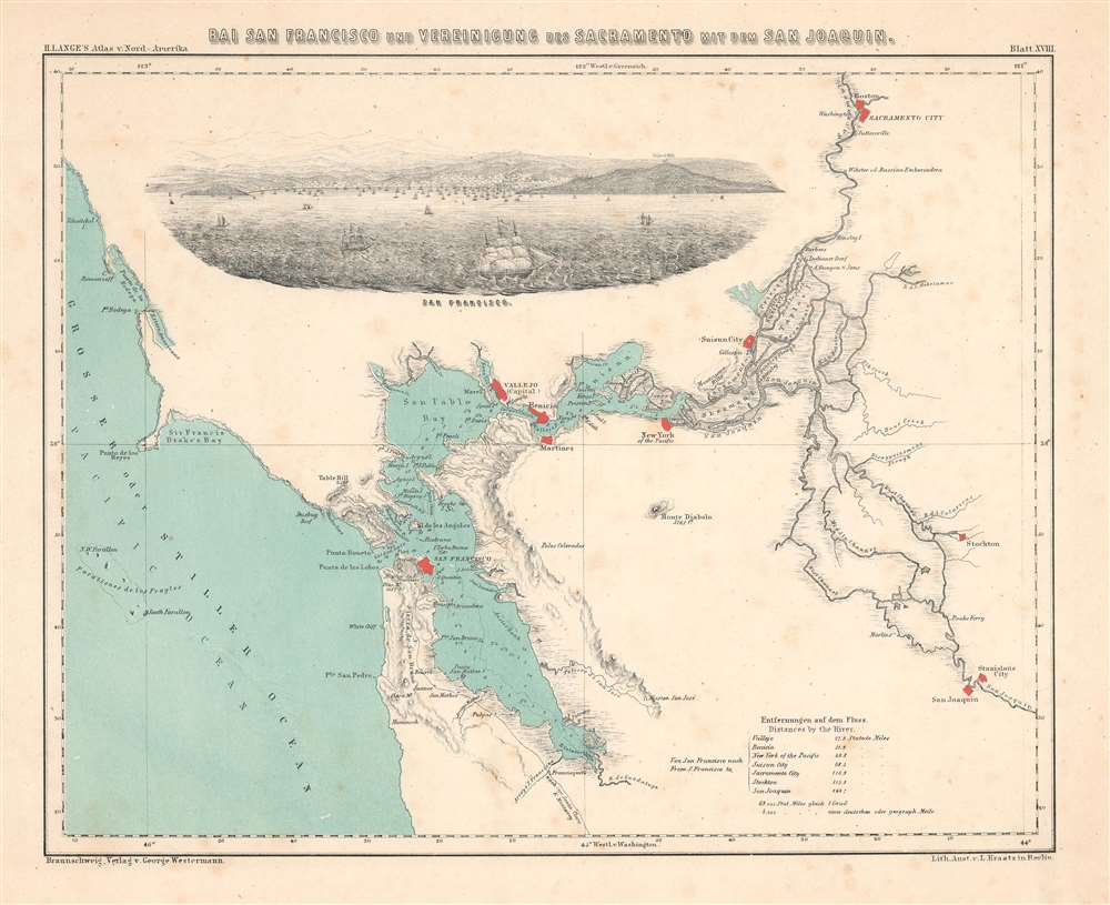
Bai San Francisco und Vereinigung des Sacramento mit dem San Juaquin.
1854 (undated) 9.5 x 11.5 in (24.13 x 29.21 cm) 1 : 760000
1854 (undated) 9.5 x 11.5 in (24.13 x 29.21 cm) 1 : 760000
Description
This is a bilingual English and German 1854 Henry Lange map of San Francisco Bay and the surrounding region. The first specific map of San Francisco Bay in a foreign language, it depicts the region from the Pacific Ocean to Sacramento and from Sacramento to San Joaquin. Depth soundings appear throughout San Francisco Bay, San Pablo Bay, and Suisun Bay. Points, islands, straits, and other coastal features are illustrated, providing a detailed view of the bay and its hazards. San Francisco, Vallejo, New York of the Pacific, Sacramento City, Stockton, and San Joaquin are highlighted in red. The region's extensive river system is illustrated in detail, and its creek, streams, and rivers are all labeled.
The Grand View
A grand, spectacular early view of San Francisco Bay dominates the upper left quarter of the map. Ships crowd the bay in the background, with San Francisco expanding into the hills. A handful of ships sail south along the coast. A distance chart from San Francisco to seven other cities, including Sacramento, appears on the lower right.Publication History and Census
This map was created by Henry Lange, lithographed by L. Kraatz, and published by George Westermann in Lange's Atlas von Nord-Amerika in 1854. It is well represented institutionally but is scarce on the private market.CartographerS
Henry Lange (April 13, 1821 - August 30, 1893) was a German writer and cartographer. Born in Stettin, Lange attended Heinrich Berghaus's cartography school in Potsdam. For three years, beginning in 1844, Lange worked on Scottish geographer Alexander Keith Johnston's (1804 - 1871) first Physical Atlas. He returned to Germany in 1847 and worked as a freelance cartographer in Berlin. During this time he produced maps for researchers and publishers in Berling, including Alexander von Humboldt, Heinrich Kiepert, Heinrich Barth, and Carl Ritter. Lange set up the cartographic department for FA Brockhaus, a publishing house in Leipzig, between 1855 and 1859, after which he returned to creating commissioned works. He earned a position wit the Royal Statistical Office in 1868, a position he held until he retired in 1891. Lange played an instrumental role in founding the Central Association for Commercial Cartography and the promotion of German interests abroad. During the course of his career, Lange produced hand and travel atlases, Bible atlases, and works of industrial and commercial geography. He is most often remembered for his works of school cartography, which were published by George Westermann (1810 - 1879). Among these were the Neuesten Schulatlas sum Unterrichte in der Erdkunde, for which he made revisions for ninety editions until 1892. Another of his extremely successful school atlases Neue Volkschulatlas über all Teile Der Erde had over 230 editions and printed over 2.4 million printed copies from 1871 until Lange's death. More by this mapmaker...
Georg (George) Westermann (February 23, 1810 - September 7, 1879) was a German publisher and the founder of Westermann Verlag, based in Braunschweig, which still exists to this day and publishes as part of the Westermann Group. Born in Leipzig, Westermann attended the Humanistic Gymnasium Albertina in Freiberg before moving to Brunswick to work as an apprentice to a book publisher and seller in 1827. He founded his own publishing bookstore in Braunschweig in 1838 and married Blanca Vieweg on November 29th of that year. Westermann expanded his operation in 1845 by acquiring his own printing works, which he later supplemented with a lithographic machine, steam-powered letterpresses, and a bookbindery. After Westermann died in 1879, his son Friedrich took over the business. Learn More...
Source
Lange, H., Atlas von Nord-Amerika (Braunschweig: Westermann) 1854.
Condition
Very good. Blank on verso.
References
Rumsey 2743.018. OCLC 25893753.