
1595 Ortelius Map of Basel, Switzerland and Swabia

This item has been sold.
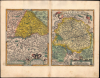
Basiliensis Territorii Descriptio Nova / Circulus sive liga Sveviae, vulgo Schwabische Kraiss.
The Consolidation of Swiss Autonomy.
- Digital Map Information
- Suitable for large format printing
- Full resolution TIFF file
- ICC color profile embedded
- Delivered instantly via download link
The Consolidation of Swiss Autonomy.
This is an old-color example of Abraham Ortelius' two-map sheet covering Basel and environs along today's Swiss-French-German border and an area further east spanning the modern borders of Switzerland, Germany, Austria, and Liechtenstein. The map presents these regions in the era of the Reformation and internal struggles of the Holy Roman Empire, which saw the Swiss Confederacy strengthened despite being internally divided by religious affiliation.A Closer Look
The map at left, oriented towards the east, covers an area between the eastern end of the Vosges Mountains and Ochsenfeld in today's southeastern France to Baden, taking in Basel, which appears at center. Cities and towns, including Freiburg (im Breisgau) are labelled throughout, while mountains, forests, and rivers are illustrated. The map contains several references to Antiquity, the tribes that inhabited this area, and the ancient settlement along the Rhine known as Augusta Raurica ('Augst.' on the map), with discussion on the verso elaborating these terms.The map at right, oriented towards the north, covers a wide area around the Bodensee (Lake Constance) and Swabia, from Zurich (Zurch) and Strasbourg in the west to Augsburg in the east, roughly centered on Ulm. Cities and towns (including Pforzheim, Stuttgart, and Tübingen), forests, mountains, and rivers (including the Upper Danube, here as Donaw / Tonaw) are labelled throughout.
Historical Context
The two regions represented here were linked by more than general geographical proximity in the 16th century. That is because at the very end of the 15th century, the two were involved in the Swabian War (1499), in which the Swabian League was sent by the Habsburg Emperor Maximilian I to battle the Old Swiss Confederacy. Boasting some of the most battle-hardened troops in Europe who were additionally motivated by defending their home turf, the Swiss fended off the Swabian attacks and forced Maximilian to grant them de facto independence. The whole affair strengthened the Confederacy, which soon grew to include Basel, Schaffhausen, and Appenzell, resulting in the Thirteen Cantons that would last for nearly 300 years.The Confederacy managed to hold together through the Protestant Reformation, despite powerful sectarian tensions. Though different cities and cantons aligned with one side or the other and generally tried to expel dissidents, open warfare was averted until 1531 with the brief Second War of Kappel (the First 'War' of Kappel was avoided through negotiation at the last moment), which saw the death in battle of Huldrych Zwingli (1484 - 1531), a leader of the Reformation in Switzerland committed to expelling Catholicism. Afterwards, the cantons adopted an early form of the doctrine of Cuius regio eius religio, in other words, cantons would be either Catholic or Protestant (with two evenly divided) and would not interfere in the affairs of cantons of the other faith. Although this hardly ended religious tensions in Switzerland, it did provide a framework for allowing the Confederacy to continue without brutal, protracted confessional warfare as occurred elsewhere in Europe.
Swabia was not so fortunate, being subject to the similar types of religious wars and power struggles seen elsewhere in the Holy Roman Empire. Indeed, the Swabian League was disbanded in 1534 in part on account of religious conflict among its members. This area saw some of the most intense fighting during the German Peasants' War, among other 16th-century conflicts.
Publication History and Census
This sheet was published by Abraham Ortelius in the 1595 Latin edition of the Theatrum Orbis Terrarum, of which 500 Copies were printed. The map at left is based on an earlier work by Sebastian Münster, while that at right is drawn from a 1572 map by Dauid Seltzlin (c. 1536 - 1609). In its different iterations, this map appeared in the Theatrum between 1573 and 1609; it is well-represented in institutional collections and occasionally appears on the market. That being said, the present edition is not independently cataloged in the OCLC.Cartographers
Abraham Ortelius (April 14, 1527 - June 28, 1598) also known as Ortels, was a cartographer, geographer, and cosmographer of Brabant, active in Antwerp. He was the creator of the first modern atlas, Theatrum Orbis Terrarum and is a seminal figure in the history of cartography. Along with Gerard Mercator and Gemma Frisius, he was a founder of the Netherlandish school of cartography. His connections with Spain - culminating in his 1575 appointment as Royal Cartographer to King Phillip II of Spain - gave him unmatched access to Spanish geographical knowledge during a crucial period of the Age of Discovery. Ortelius was born in 1527 in Antwerp. In 1547 he entered the Antwerp Guild of Saint Luke as an illuminator of maps. He began trading in books, prints, and maps, traveling regularly to the Frankfurt book and print fair, where in 1554 he met Mercator. He accompanied Mercator on journeys throughout France in 1560 and it was at this time, under Mercator's influence, that he appears to have chosen his career as a scientific geographer. His first published geographic work appeared in 1564, an eight-sheet cordiform world map. A handful of other maps preceded the 1570 publication of the first edition of the Theatrum Orbis Terrarum, which would prove to be his life work. Appearing with but 53 maps in its first edition, Ortelius' work expanded with new maps added regularly. By 1592, it had 134 maps. Many of Ortelius' maps remained the standard for nearly a century. He traveled extensively, but his genius was as a compiler, locating the best informed maps on which to base his own. His contacts throughout Europe and extending even (via the Portuguese) to the Far East were formidable. Moreover, many of his maps were based on his own scholarship, particularly his historical works. His theories of geography were particularly ahead of his time with respect to the notion of continental drift, the possibility of which he mused on as early as 1596, and which would be proven correct centuries later. In a sense his greatest achievement was his successful navigation of the religious and political violence endemic to his city throughout his adult life: The Dutch Revolt, or Eighty Years' War (1568 - 1648), fully embroiled Antwerp. Although outwardly and officially recognized as Catholic (Arias Montanus vouched for Ortelius' Catholic orthodoxy prior to his appointment as Royal Geographer), Ortelius was able to separate himself from the religious furor which characterized the war in the low countries. Ortelius showed a glimpse of himself in a letter to a friend, regarding humanist Justus Lipsius: 'I do not know whether he is an adherent of the Pope or a Calvinist, but if he has ears to hear, he will neither be one nor the other, for sins are committed on both sides'. Ortelius' own explorations of Biblical history in his maps, and the Christogram contained in his own motto, suggest him to be a religious man, but his abjuration of political religious authorities mark him as an individualist. His tombstone at St Michael's Præmonstratensian Abbey in Antwerp bears the inscription, Quietis cultor sine lite, uxore, prole. ('served quietly, without accusation, wife, and offspring.') Further Details...
Sebastian Münster (January 20, 1488 - May 26, 1552), was a German cartographer, cosmographer, Hebrew scholar and humanist. He was born at Ingelheim near Mainz, the son of Andreas Munster. He completed his studies at the Eberhard-Karls-Universität Tübingen in 1518, after which he was appointed to the University of Basel in 1527. As Professor of Hebrew, he edited the Hebrew Bible, accompanied by a Latin translation. In 1540 he published a Latin edition of Ptolemy's Geographia, which presented the ancient cartographer's 2nd century geographical data supplemented systematically with maps of the modern world. This was followed by what can be considered his principal work, the Cosmographia. First issued in 1544, this was the earliest German description of the modern world. It would become the go-to book for any literate layperson who wished to know about anywhere that was further than a day's journey from home. In preparation for his work on Cosmographia, Münster reached out to humanists around Europe and especially within the Holy Roman Empire, enlisting colleagues to provide him with up-to-date maps and views of their countries and cities, with the result that the book contains a disproportionate number of maps providing the first modern depictions of the areas they depict. Münster, as a religious man, was not producing a travel guide. Just as his work in ancient languages was intended to provide his students with as direct a connection as possible to scriptural revelation, his object in producing Cosmographia was to provide the reader with a description of all of creation: a further means of gaining revelation. The book, unsurprisingly, proved popular and was reissued in numerous editions and languages including Latin, French, Italian, and Czech. The last German edition was published in 1628, long after Münster's death of the plague in 1552. Cosmographia was one of the most successful and popular books of the 16th century, passing through 24 editions between 1544 and 1628. This success was due in part to its fascinating woodcuts (some by Hans Holbein the Younger, Urs Graf, Hans Rudolph Manuel Deutsch, and David Kandel). Münster's work was highly influential in reviving classical geography in 16th century Europe, and providing the intellectual foundations for the production of later compilations of cartographic work, such as Ortelius' Theatrum Orbis Terrarum Münster's output includes a small format 1536 map of Europe; the 1532 Grynaeus map of the world is also attributed to him. His non-geographical output includes Dictionarium trilingue in Latin, Greek, and Hebrew, and his 1537 Hebrew Gospel of Matthew. Most of Munster's work was published by his stepson, Heinrich Petri (Henricus Petrus), and his son Sebastian Henric Petri. Further Details...
Source
Ortelius, A., Theatrum Orbis Terrarum, (Antwerp: Plantin) 1595.
Abraham Ortelius' magnum opus, Theatrum Orbis Terrarum, was the world's first regularly produced atlas, which 'set the standards for later atlases ... It was the first undertaking of its kind to reduce the best available maps to an uniform format.' (Koeman) A modestly-sized work of fifty-three maps in its first edition of May 1570, it was an immediate success: there were three further editions that year, and the work remained in print for a total of 32 editions, the last of which was 1641, well after its author's 1598 death. Ortelius added to his atlas constantly, and by 1595 the Theatrum contained 147 maps. Ortelius is renowned generally as an editor, and indeed much of the Theatrum is compiled from a variety of sources: in such cases, Ortelius was scrupulous in naming his sources. But Ortelius was also a mapmaker in his own right: many of his maps are a distillation of various sources into his own work, and there were many maps - particularly in his atlas of Biblical and ancient history Parergon - which were entirely Ortelius' work. In his role as an editor, Ortelius followed in the footsteps of Munster, whose Cosmographia was, until Ortelius, the best window on the world for the curious European reader. In terms of the artistry of his maps, Ortelius oversaw the first great flourishing of copperplate engraving in the service of cartography to occur in Northern Europe. Ortelius' work provided the model for the atlases of Mercator, Hondius, Blaeu and all their progeny in the 17th century - many of whom were to produce faithful editions of Ortelius' maps in their own productions.
Condition
Very good. Light stains in bottom margin.