1879 Tweedy Map of the Beaver River, Adirondack Region, New York
BeaverRiverNY-tweedy-1879$400.00

Title
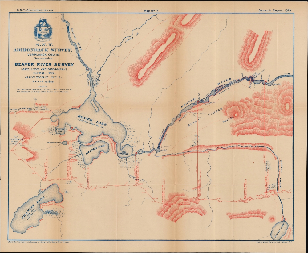
Beaver River Survey (Base-Lines and Topography), 1876-79. Section No. 1.
1879 (dated) 18 x 22 in (45.72 x 55.88 cm) 1 : 12000
1879 (dated) 18 x 22 in (45.72 x 55.88 cm) 1 : 12000
Description
A colorful 1879 map of Beaver Lake in Lewis County, the Adirondacks, New York, drawn by Frank Tweedy for Verplanck Colvin's Topographical Survey of the Adirondack Region. Europeans settled this portion of New York sporadically since the 17th century. Nonetheless, the thick forests and mountains made surveying so onerous that it was not mapped thoroughly until the late 19th century.
A Closer Look
Today, these lands are part of Lowville, the seat of Lewis County, or Watson, though the center of both are more than 15 miles from the area mapped. The map highlights the Beaver River, Beaver Lake, Beaver Dam, Francis Lake, and, at the bottom-right, Sunday Lake. On land, topography is indicated with hachures, while marshy terrain is illustrated on the banks of waterways. Benchmarks and stations used by surveyors, and paths between them, are traced in red. An area of burnt timber along the Beaver River is marked at right. The Fenton House, at left, was built in 1826 and provided accommodations for visitors and tourists, who mostly came in the summer to hunt and fish.Colvin's Survey of the Adirondacks
Verplanck Colvin became the first person to summit Seward Mountain in 1870. From that panoramic high point, he was brutally confronted by rampant deforestation then quickly destroying the Adirondacks. Personally shaken by the sight, and concerned about the viability of New York's water supply and the Erie Canal if the deforestation continued, Colvin lobbied the state to sponsor a survey of the Adirondacks. This effort resulted in a detailed report calling for the protection of the Adirondack watershed. Subsequent reports, such as the Seventh Annual Report in which the present map appeared, provided the first detailed surveys of the region. These, in turn, led to the creation of the Forest Preserve and Adirondack Park, a 6.1-million-acre park in upstate New York that encompasses more than 10,000 lakes, 30,000 miles of streams and rivers, and an estimated 200,000 acres of old-growth forests. The Forest refers to all lands owned by the state of New York within the Adirondack, and later Catskill, parks.Publication History and Census
This map was drawn by Frank Tweedy and lithographed by Weed Parsons and Co. It appeared as Map No. 7 in the Seventh Annual Report on the Progress of the Topographical Survey of the Adirondack Region of New York, to the Year 1879. It is not independently cataloged by any institution in the OCLC.CartographerS
Frank Tweedy (1854 - 1937) was a topographer and botanist best known for his maps of Yellowstone National Park. Born and raised in New York City, Tweedy spent summers in the Adirondack Mountains, inculcating a familiarity with the region that would later be central to his career. He attended Union College in Schenectady and studied civil engineering. He worked as a surveyor with the Adirondack Survey in the late 1870s, where his work in the densely wooded Beaver River region won plaudits from Verplanck Colvin, founder and head of the survey. He then took a job as a sanitation engineer in Newport, Rhode Island, before joining the Northern Pacific Survey in Washington Territory in 1882. In 1884, he began working for the U.S. Geological Survey, where he remained for the rest of his career, conducting surveys throughout the American West. All along, he pursued an interest in botany, collecting and categorizing plants; his collections and descriptions were so important that at least 35 plant taxa have been named in his honor. More by this mapmaker...
Weed, Parsons and Company (July 25, 1843 - July, 1892) was a New York based printing house based in Albany, active in the second half of the 19th century. The firm was founded by J. B. Weed (???? - June 18, 1851) and John D. Parsons. Weed, the son of Thurlow Weed, previously worked for the Evening Journal. Parsons was a compositor in the printing offices of Packard and Van Benthuysen. Shortly after their startup, the firm received financing from Visscher Ten Eyck, one of the owners of the Evening Journal to dramatically expand their printing operation. Leveraging Parsons' contacts with the state, the firm began receiving lucrative government printing contracts out of Albany. By 1868 they were one of the largest printing concerns in the United States. Their offices were gutted by a major fire on April 7, 1871. The owners rebuilt with new more modern equipment and continued to operate, with heirs taking over the shares of the original owners. They remained in operation until the firm went into receivership in July of 1892. Learn More...
Verplanck Colvin (January 4, 1847 - May 28, 1920) was an American topographical engineer, author, illustrator, and lawyer whose environmental efforts in the Adirondacks led to the creation of New York's Forest Preserve and the Adirondack Park. Born in Albany, New York, Colvin was the son of Andrew James Colvin and his second wife Margaret Crane Alling. Colvin's first name (Verplanck) was his grandmother's maiden name). As a boy he attended the Albany Academy, and the Nassau Academy after his family moved to Nassau during the American Civil War. He graduated in 1864 and intended to attend The United States Military Academy at West Point, but instead joined his father's law practice in Albany and was admitted to the bar soon afterward. Real estate law allowed Colvin his first taste of surveying. Colvin found his love of the Adirondack Mountains in 1865, after reading Alfred Billings Street's book Woods and Waters which detailed Street's adventures in the region. He first ascended Mount Marcy in 1869, and logged the first recorded ascent of Seward Mountain in 1870. While ascending Seward, Colvin noticed the devastation wrought on the environment by unregulated logging. Combatting logging and preserving the Adirondack wilderness became his lifelong passion. Colvin applied for funding to undertake a survey of the Adirondacks in 1872, and received a $1000 stipend from the state. During the first year of the survey he discovered what is often considered to be the source of the Hudson River, Lake Tear-of-the-Clouds. He also. Became obsessed with determining the exact altitude of the region's highest mountains and went to extreme lengths to achieve this goal. For example, to determine the precise altitude of Mount Marcy, Colvin and his men established a series of 111 elevation benchmarks along a forty mile trek from Westport, on Lake Champlain, to the summit of Mount Marcy. He wrote a scathing report in 1873 stating that if the Adirondack watershed were allowed to continue to deteriorate, it would threaten the viability of the Erie Canal, then an essential component of New York's economy. Colvin wanted to create a state forest preserve to protect the entire Adirondack region. Following the publication of his report, Colvin was appointed superintendent of the New York state land survey, which, in turn, led to the creation of the Adirondack Forest Preserve in 1885. Colvin served in this position until 1900, when its duties were transferred to the state engineer by then Governor Theodore Roosevelt. Over the course of his career, he served as president of the department of physical science at the Albany Institute, lectured at Hamilton College, and ran on the Republican ticket for New York State Engineer and Surveyor in 1891, but lost the election to Democrat Martin Schenck. Today, his maps reports, notes, and illustrations are part of the archives of the New York Department of Environmental Conservation in Albany and are still referenced by present-day surveyors. Learn More...
Source
Colvin, V., Seventh Annual Report on the Progress of the Topographical Survey of the Adirondack Region of New York, to the Year 1879, (Albany: Weed Parsons) 1880.
Condition
Very good. Light wear along original fold lines. Verso repairs to separations at fold intersections. Closed tear at insertion point not entering printed image professionally repaired on verso.