
1937 Minguo 26 Beiping Xidan Yinnan Map of Beijing Suburbs, China

This item has been sold.
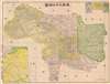
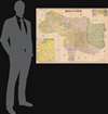
最詳北平四郊圖 / [Most detailed map of the four suburbs of Beiping].
Republican Era Beijing.
- Digital Map Information
- Suitable for large format printing
- File Size: 59.78 MB
- File Type: ZIP / TIFF
- ICC color profile embedded
- Delivered instantly via download link
Republican Era Beijing.
This is a very rare Bai Meichu (白眉初) map of Beijing (Beiping) from 1937, on the eve of the Second Sino-Japanese War (1937 - 1945). The map features unique annotations that suggest hands-on administrative use in urban development and city planning during this critical period.A Closer Look
The map illustrates the six inner and five outer districts of Beiping City (within the city walls) and its four suburbs, as well as the names of neighboring counties. It includes a large inset (1 : 625000) of the Beijing vicinity, including its borders with Chahar and Rehe. There are three inset maps at the top-right showing Beihai Park, the Forbidden City, and the Summer Palace, and a legend denoting symbols used to identify geographic features, infrastructure (roads, rail, bridges, walls), temples, pagodas, wells, and agriculture (orchards, tea, paddies, and fields).Annotations
The original owner has made several annotations in red, black, and blue pencil, mainly in the northern suburbs (北郊), starting near Deshengmen (德勝門), one of the city's main northern gates. The owner has traced a blue line to a nearby rail line, which follows the same route as today's Subway Line 13, near Qinghua Station (清華車站), and several Buddhist Temples, indicated by swastikas, have been marked in red and one has been circled at Liulongquan (九龍泉). There are also annotations in the inner and outer districts of Beiping city with red lines and circles, and Beichizi (北池子), just east of the Forbidden City, has been circled. Given the institution that produced this map, the owner may have been involved in urban planning and construction at the sites marked.Beijing in the Republican Era (1912 - 1949)
Beijing has gone through many name changes. As the capital of the Mongol Yuan Dynasty, it was known as Dadu. Beijing (meaning 'northern capital') came into use in 1403, when the Ming Emperor Yongle moved the capital from Nanjing ('southern capital') to be closer to the front line of the Ming's ongoing war with the Mongols. Under the Ming, Beijing began to take on its modern form, with the Forbidden City, the city walls protecting and separating the inner and outer city, and many of the temples. The Qing expanded and improved the already-grandiose Ming city. Beijing was initially the capital after the fall of the imperial dynasty and the transition to a republic, but it suffered a decline when the national capital was moved (back) to Nanjing by Chiang Kai-shek in 1927-28. At this time, Beijing was renamed Beiping. The city was administratively reorganized into districts and suburbs with rational yet uninspiring names (District 1, District 2, North Suburb, West Suburb, etc.). Soon afterward, in the mid-1930s, the Japanese military gradually approached the city in an on-again, off-again conflict with Chinese forces. One of these many skirmishes took place on July 7, 1937, soon after this map was produced, at the 'Marco Polo Bridge' at Lugouwiao 盧溝橋 (Wanping; 宛平), just to the southwest of the area here detailed. However, by this point, Chiang Kai-shek had to bow to public opinion and, somewhat reluctantly, throw his armies into a full-scale war against the better-trained and equipped Japanese. In retrospect, the 'Marco Polo Bridge Incident' is generally seen as the start of the Second Sino-Japanese War and World War II in Asia.Publication History and Census
This is a first edition (初版), produced in February 1937 by Bai Meichu (白眉初) for the Beiping Xidan Yinnan Construction Library (北平西單迤南建設圖書館). The map is rare. We note a single example at the Capital Library of China in Beijing.Cartographers
Bai Meichu (白眉初; 1875 or 1876 - 1940) was a prominent cartographer and geographer of the Republican era who wrote or compiled over a dozen works, played a leading role in the Geographical Society of China (中國地學會), and taught at Zhili Women's Normal School (the predecessor to today's Hebei Normal University) and Beijing Normal University. Among his major works were A Complete Chronicle of the Provinces and Regions of the Republic of China (中華民國省區全誌, 5 vols. 1924-27). Bai was involved in intellectual and revolutionary circles in Beijing, and came to be friends with Li Dazhao, a professor at Peking University and one of the founders of the Chinese Communist Party. He is remembered today not only as an important figure in the history of geography in China, but also as a patriot who sought to use geography as a means to challenge foreign imperialism and serve the nation. Bai, who had once published a National Humiliation Map of China (中國國恥圖), is most famous for being the first Chinese geographer to use the now-infamous 'nine-dash line' (九段线) in a 1936 map to claim virtually all of the South China Sea for China. His 1936 map was an inspiration for Chiang Kai-Shek's Nationalist regime, which used it and the nine-dash line in territorial disputes following the end of World War II, a practice that continued with the People's Republic government after 1949. Further Details...
Beiping Construction Library (北平建設圖書館, sometimes Beiping Xidan Yinnan Construction Library 北平西單迤南建設圖書館, or simply Construction Library 建設圖書館; c. 1928 – 1936) was a publisher of maps and books on geography, architecture, history, and other topics. Further Details...
Condition
Good. Original fold lines and some edges reinforced on verso with archival tissue. Very minor infill at some fold intersections.