
1949 Seymour Pictorial Airline Map of the Western Hemisphere, B.O.A.C.

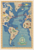

B.O.A.C. World Air Routes Western Hemisphere.
Hopping across 'the Pond'.
- Digital Map Information
- Suitable for large format printing
- Full resolution TIFF file
- ICC color profile embedded
- Delivered instantly via download link
Hopping across 'the Pond'.
This is a c. 1949 E. O. Seymour pictorial map of the Western Hemisphere produced for the British Overseas Air Corporation (B.O.A.C.). It was prepared during the airline's 'Golden Age,' when a Postwar commercial air travel boom was taking flight and travel between continents was becoming increasingly accessible.A Closer Look
Done in the charming pictorial style pioneered by French artist Lucien Boucher for Air France, this map covers the Western Hemisphere (loosely defined). The routes of B.O.A.C. between different cities are traced, while illustrations depict representative architecture, clothing, customs, and characteristics of different destinations, even those not reached by B.O.A.C., such as Mexico and Peru/Bolivia. The routes reflect the increased importance of Transatlantic ties since the start of the Second World War, as well as the status and legacy of the British Empire, disintegrating at the time but maintaining ties through the Commonwealth (this map coinciding with the 1949 London Declaration, which established the Commonwealth in its modern form).Historical Context
The British Overseas Airways Corporation was officially forged in the crucible of 1939, just as the world descended into total war. Created by a Parliamentary Act that merged the struggling Imperial Airways and British Airways, Ltd., B.O.A.C. spent its infancy as a vital strategic asset for the British government. Throughout World War II, the airline maintained 'lifeline' routes across the Atlantic and to the far reaches of the British Empire, often flying unarmed and camouflaged aircraft through contested airspace. In the immediate aftermath of 1945, B.O.A.C. faced a difficult transition from military support to commercial competition. The airline grappled with a fragmented fleet; while national pride dictated the use of British-made aircraft, many were merely converted bombers like the Avro Lancastrian that could not match the efficiency of American-made Lockheed Constellations. Despite these growing pains, the late 1940s remained the airline's 'Golden Age,' with luxury Short Solent flying boats departing from Southampton to serve routes across Africa and Asia. The era reached a major turning point in 1949 when B.O.A.C. absorbed British South American Airways (BSAA), consolidating Britain's long-haul operations under one banner and clearing the path for the looming revolution of the jet age.The Speedbird
The 'Speedbird,' appearing on this map next to the title, is a stylized emblem of a bird in flight designed in 1932 by Theyre Lee-Elliott as the logo of Imperial Airways. When Imperial Airways merged with British Airways Ltd., forming the British Overseas Airways Corporation (B.O.A.C.), the logo was retained. B.O.A.C. eventually became British Airways. The Speedbird logo continued to be used until finally being retired in 1984.Publication History and Census
This map was drawn by artist E.O. Seymour and published by the British Overseas Airways Corporation, likely in 1949 or shortly thereafter. There are multiple printings of this map and its accompanying Eastern Hemisphere sheet (dated to 1949), sometimes printed back-to-back and sometimes separated, as here. The present example is also notable and apparently rarer for using red rather than black lines to indicate air routes, which are also somewhat more numerous than in the earlier edition, especially Transatlantic flights (though losing a route between Kingston-Panama City-Santiago, see our BOACEastWest-seymour-1949 for comparison). We are aware of examples with red routes, but with fewer Transatlantic routes, suggesting at least three printings. It is easy to imagine that B.O.A.C. issued these in quick succession in 1949 and perhaps the following year or two as their network rapidly expanded. Since these all share the same title and publication information, it would be impossible to distinguish them in catalog listings without a digitized image. In any event, we only locate one example in the OCLC, held by the University of California San Diego (printed back-to-back), while the David Rumsey Historical Map Collection also holds two editions (printed back-to-back, one with the less numerous routes in black and the other with more numerous routes in black).Cartographer
E.O. Seymour (fl. c. 1949 - 1952) was a British postwar commercial artist and illustrator who produced works for airlines, especially the British Overseas Airways Corporation (BOAC). Little information about him is available, even his full name, and his known works number only four, pictorial air route maps of the Eastern and Western Hemisphere for BOAC, a travel poster for BOAC titled 'Fly to South America' and featuring a depiction of an old mission church, and a similar poster titled 'Fly to South Africa' for South African Airways. Further Details...
Condition
Very good. Laid down on linen, poster style. Some restoration along original fold lines, particularly the centerfold.
References
Rumsey 8740.001 (alternate printing), 14072.001 (earlier ed.). OCLC 802411843 (alternate printing).