
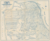
1894 Britton and Rey Map of San Francisco, California

This item has been sold.
Britton and Rey's Guide Map of the City of San Francisco Compiled from the Latest Official Data.
Plotting out the City by the Bay.
- Digital Map Information
- Suitable for large format printing
- Full resolution TIFF file
- ICC color profile embedded
- Delivered instantly via download link
Plotting out the City by the Bay.
This is a c. 1894 map of San Francisco prepared by local printers Britton and Rey for Richards' Official Guide and Maps of San Francisco Street Railways. The map captures San Francisco as it expanded beyond the original downtown core formed during the Gold Rush era into the western and southern sections.A Closer Look
This map covers the City and County of San Francisco (harmonized by this time), with streets labeled and parks, cemeteries, docks, piers, government reservations, street railways (whether steam, electric, or cable car), and public institutions noted. Concentric circles emanate from City Hall at half-mile intervals. The remnants of some of the area's historic Mexican-era ranchos are recorded, while the city's famous hills are only barely referenced at Buena Vista Park and Twin Peaks. The original water line is faintly traced, a remnant of the early official surveys undertaken by city surveyor William Eddy and his associates.The street grid seen here had been officially laid out following the resolution of legal wrangling over the 'Outside Lands' (Richmond and Sunset Districts, along with Golden Gate Park) around 1870, but these streets existed primarily on paper. At the time of publication, today's Richmond, Sunset (which has its blocks numbered), and Bayview Districts, along with other outlying parts of the city, were only partially developed, though were increasingly being forced to conform to the planned city grid (for example, a horse racing track adjacent to Odd Fellows Cemetery was in the process of being closed at the time and does not appear here). Due to the somewhat tentative nature of the projected streets and blocks, as well as later damage done by the 1906 earthquake and fire, some notable differences can be easily spotted when compared to a modern map of the city. For example, the area south of Twin Peaks (around Glen Canyon Park and Mt. Davidson) would ultimately develop a street plan that followed the contours of the land rather than the rigid geometric grid seen here. The same can be said for the ghosted-in development around Lake Merced, today's Park Merced development, and the extensions of Balboa Boulevard and Market St., the latter of which (now Portola Dr. from Twin Peaks onwards) follows something like the route laid out here, though not as straight, again to follow the contours of the land.
Historical Context
This map was prepared the same year that millionaire Adolph Sutro was elected mayor on the Populist ticket, despite his own considerable wealth (he owned roughly one-twelfth of all the land in the city). Sutro's personal estate in the northwestern corner of the city was adjacent to the Cliff House, Seal Rocks, and Sutro Baths, which opened in 1894. A German-born Jew who engineered the tunnel allowing for the exploitation of the Comstock Lode, Sutro had an inexhaustible drive to take on new projects, many philanthropic. Much of Sutro's political platform was directed towards the city's political machine, which was seen to be firmly in the hands of the Southern Pacific Railroad. Among his efforts to combat the SPRR, which also was heavily invested in the city's streetcar network, was the construction of a rail line directly to his estate and the nearby attractions along the north side of the nearby cemetery (later Fort Miley / Lincoln Park). But despite being elected in a landslide, Sutro's mayoralty was not particularly successful due to his political inexperience and the limitations of the mayorship vis-à-vis the Board of Supervisors.Publication History and Census
This map was prepared by San Francisco printing powerhouse Britton and Rey in 1894 for the first edition of George Richards' Official Guide and Maps of San Francisco Street Railways, which accompanies the map here. Britton and Rey had produced a 'Guide Map' of San Francisco for various city directories since at least 1876, but this is the first edition of this iteration of the map (some catalog listings place the date of the guide at 1894, as here, while at least one lists 1896 for the first edition, perhaps a later printing). The map alone is cataloged in the OCLC at Stanford University (though the catalog listing refers to it as a photocopy), while the entire guide is noted at the Society of California Pioneers, the University of California Berkeley, St. Patrick's Seminary and University, and the San Diego Public Library, in addition to Stanford.Cartographers
Britton and Rey (1852 - 1916) was a lithographic firm based in San Francisco founded by Joseph Britton (1825 - 1901) and Jacques Joseph Rey (1820 - 1892). The leading firm in the area during the second half of the 19th century, Britton and Rey eventually earned the reputation of being the western Currier and Ives. They published both large-format and postcard views of California, as well as with stock certificates, stationery, and maps. Within the partnership, Rey was the artist and Britton the principal lithographer. Britton was also principally concerned with the business aspects of the firm. The firm also printed lithographs by other artists, including Thomas Almond Ayres (1816 - 1858), George Holbrook Baker (1824 - 1906), Charles Christian Nahl (1818 - 1878), and Frederick August Wenderoth (1819 - 1884). After Rey's death in 1892 and Britton's subsequent retirement, the firm passed to Rey's son, Valentine J. A. Rey, who ran the firm until at least the 1906 San Francisco earthquake and fire. A. Carlisle and Company, another San Francisco printer, acquired the remains of the Britton and Rey firm in 1916. For more information about Joseph Britton and Jacques Joseph Rey, please reference their individual biographies included in our cartographer database. Further Details...
Joseph Britton (1825 - July 18, 1901) was born in Yorkshire, England, and immigrated to the United States in 1835 with his family, living in New York City, becoming a lithographer by 1847. In 1849, he left New York to seek his fortune in California during the California Gold Rush. He made the journey with George Gordon’s ‘Gordon’s California Association’, and chose the voyage which included an overland trek via Nicaragua. The voyage was supposed to last 60 days, but instead lasted an incredible 8 months. After several unsuccessful years in various gold mining camps, Britton relocated to San Francisco and established a lithography firm, probably in 1851, and then entered into a short-lived collaboration with C.J. Pollard in 1852, named Pollard and Britton. By late 1852, Britton had formed a partnership with the lithographer Jacques Joseph Rey. Rey married Britton’s sister in 1855, but Britton remained a life-long bachelor and lived with the Rey family. Rey and Britton were well integrated into San Francisco. They owned a plumbing and gas-fitting firm, which apparently Rey managed. They also worked with several different lithographers off and on, but their partnership solidified by 1867. Britton was one of the three original investors in Andres Hallidie’s first San Francisco cable-car line on Clay Street and served twice as a San Francisco City and County Supervisor. Further Details...
Jacques Joseph Rey (1820 - 1892) was born in Bouxwiller, Alsace, France, and apparently was trained in art and lithography. Around 1850, he immigrated to California. Rey, a lithographer by training, entered into a partnership with Joseph Britton (1825 - 1901) by late 1852. Rey married Britton’s sister in 1855, but Britton, who remained a life-long bachelor, lived with the newlyweds. Rey and Britton were well integrated into San Francisco. They owned a plumbing and gas-fitting firm, which apparently Rey managed. They also worked with several different lithographers off and on, but their partnership solidified by 1867. Following Rey’s death and Britton’s retirement, Rey’s son, Valentine J. A. Rey, took over the business and ran it at least until the 1906 San Francisco earthquake and fire. The firm continued to produce works until 1915, after which it was acquired by A. Carlisle and Company. Further Details...
Source
Richards, G., Official guide and maps of San Francisco street railways..., (San Francisco: Geo. E. Richards) 1894.
Condition
Very good. Minor wear on old fold lines. Some verso stabilization at fold intersections. Accompanied by Guide Book.
References
OCLC 965831512, 19854150 (entire guide).