
1869 / 1878 Scheda Folding Map of Bosnia-Herzegovina and Environs



This item has been sold.
Bosnia, Herzegovina etc. (title on slipcase)
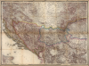
Specially-assembled folding map of Bosnia-Herzegovina.
- Digital Map Information
- Suitable for large format printing
- File Size: 122.3 MB
- File Type: ZIP / TIFF
- ICC color profile embedded
- Delivered instantly via download link
Specially-assembled folding map of Bosnia-Herzegovina.
This elegant and detailed Austrian map of Bosnia and Herzegovina, likely a unique production, was mounted and sold by Artaria, c. 1878. It is a compilation of sheets II, III, V and VI from Joseph von Scheda's General-Karte der Europaeischen Turkei und des Konigreiches Griechenland; of the 13 sheets of this mammoth map, these were the four that centered on Bosnia and Herzegovina - which had been awarded to Austria - Hungary by the terms of the Treaty of Berlin in 1878. Hence, the immediate relevance of the map as presented here.A Closer Look
This richly-detailed folding map - printed to four sheets, then dissected and mounted on linen by the publisher - covers all of Bosnia and Herzegovina, along with the surrounding countries. Serbia and Montenegro appear in their entirety. The map reaches as far north as Klagenfurt, Austria; thus, most of Slovenia is included. A large part of southern Hungary dominates the northern quadrants. The Dalmatian coast of the Adriatic Sea is mapped as far north as the island of Krk/Veglia, so most of Croatia is also included. Pristina can be seen, but Kosovo appears as part of the Ottoman-held territory of Europe, known as Rumelia. Parts of Bulgaria and Romania are included in the east. Part of Italy can be glimpsed across the Adriatic in the bottom left corner of the map. The map is supremely detailed, with topography vividly depicted with shading. Railroads, high roads, and other routes are distinctly marked, down to riding trails and footpaths.A Timely and Relevant Map
Joseph von Scheda's 1869 General-Karte der Europaeischen Turkei und des Konigreiches Griechenland was a huge map of the Ottoman Empire in Europe printed to 13 sheets. It was the result of surveys executed by the Kaiserlich-Königliches Militär-Geographisches Institut, or MGI, the bureaucracy of the Austro-Hungarian military in charge of mapmaking and whose cartographic division von Scheda directed. As was the case with many maps produced by the MGI, once cleared for public dissemination this map was published by Vienna publisher Artaria.As the Ottoman Empire declined in power in the second half of the 19th century, the European great powers grew convinced that the Empire would lose its European territories, most likely to the hungrily expansionist Russian Empire. In 1875, Herzegovina's Christian Serb population revolted against the Ottoman Empire; that revolt spread into Bosnia and Serbia. In 1876, Christian revolts broke out in Bulgaria; Serbia and Montenegro declared war on the Ottoman Empire in June of 1876. As a result of the conflict, the great powers of Europe met in Berlin, and in 1878 the Treaty of Berlin assigned Bosnia-Herzegovina and part of Montenegro to Austria-Hungary. Artaria's repackaging of this relevant part of the General-Karte would appear to have been based either on a response to a customer request, or a prediction of demand.
Publication History and Census
This map was drafted by the Kaiserlich-Königliches Militär-Geographisches Institut, or MGI, under the direction of Joseph von Scheda. It was printed in 1869 by the Vienna printer Köke for public dissemination as part of the 13-sheet General-Karte der Europaeischen Turkei und des Konigreiches Griechenland. The four sheets were dissected (removing borders where they abutted each other) and mounted together on linen to create a single, folding map. While not dated, Artaria's map catalog, pasted to the verso of the map, lists maps first published as late as 1875, so the map will not have been assembled prior to that year; thematically and contextually, a publication date of 1878 is reasonable. We see only seven examples of the complete General-Karte in OCLC. While the lack of a title challenges any assessment of the population of the present combination, we see no comparable piece in institutional collections, and there is the distinct possibility that it is a unique survival.Cartographers
Joseph Scheda (1815 - July 23, 1888) was an Austrian military officer, geographer, and cartographer. He is best known for his role as director of the Kaiserlich-Königliches Militär-Geographisches Institut (MGI) in Vienna. He was born to a military family and trained as an imperial cadet in Graz. Upon graduating in 1832,he joined the Austrian Army; showing skill as a mapmaker, he was moved to the Army's Quartermaster Staff; over the next twenty years, he was placed in charge of the Army's lithography and engraving departments, and rose through the ranks. In 1869, he was placed in charge of all cartographic work at the MGI. He retired in 1876. He was widely regarded, receiving awards from all over Europe. He instituted an array of modern practices in mapmaking, particularly in the use of key systems and topography. His tenure was also marked with advances in printing, notably electroplating and high -speed lithography, which aided in the rapid production of large print runs. Further Details...
Kaiserlich-Königliches Militär-Geographisches Institut (Imperial Royal Military Geographical institute. (active 1839 - 1921) was a military institution of the Austrian Empire, responsible for producing maps for the military; the Institut was in charge of the whole process, from initial survey to reproduction and publication. It had its roots in the military topographical corps of the Cisalpine Republic, established in Milan in 1800. The corps was absorbed by the formation of the Austrian Kingdom of Lombardy-Venetia in 1814, and continued operations: gradually, the organization was transferred to Vienna, a process completed in 1839. Its directors would govern a large (and sadly anonymous) corps of geographers and engineers, producing maps of grand size and granular detail. The Institut won international renown, receiving the Grand Medal at the London Great Industrial Exhibition in 1851 for outstanding achievements in the field of military maps. This excellence was not only in surveying, but also in map printing; the Institut applied and refined technological developments in lithography, copperplate engraving, and electroplating in the reproduction of maps. While the Institut was primarily focused on the production of maps for the military, maps approved for distribution were sold via the Vienna art dealer Artaria. Further Details...
Condition
Very good. Some wear to extremities of folds, else excellent. Original slip case present; corners of covers worn but sound.
References
Not in OCLC. Compare with Rumsey 11517.