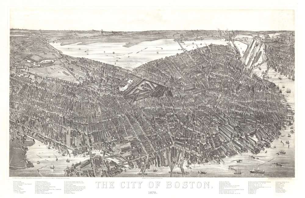
1879 Bailey / Hazen View and Map of Boston, Massachusetts
Boston-bailey-1879$15,000.00

Title
The City of Boston. 1879.
1879 (dated) 28.5 x 44 in (72.39 x 111.76 cm)
1879 (dated) 28.5 x 44 in (72.39 x 111.76 cm)
Description
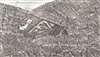
A magnificent 1879 bird's-eye view and map of Boston by James Compton Hazen and Oakley Hoopes Bailey, it is considered the largest and most detailed view of Boston Proper. The view presents Boston from an imaginary elevated position to the southeast of the city, looking northwest towards the Charles River with Cambridge appearing in the upper left and East Boston in the upper right. Hazen's slight and novel exaggeration of the vertical axis enhances the view with an intense three-dimensionality. This effect further highlighted by Hazen's use of a modified axonometric perspective - a technique that assumes a uniform fixed height and angle relative to all buildings, here modified only slightly to create a subtle perspective within the main Boston peninsula. The traditional view modality reasserts itself beyond the city proper where the background and outlying areas recede into the horizon.
Looking at the View
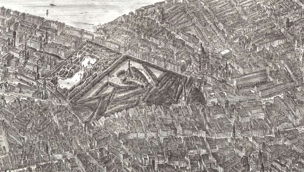
The fine realistic detail is both striking and somewhat revolutionary, unlike any other American city view of which we are aware. The view centers on Boston Common and to the right of the Common, the old city center is entrancing with its irregular and confusing street layout. To the left, the more orderly grid of the Back Bay and Columbus is evident. At the western end of the map the Fenway is recognizable and development in the Back Bay is notably still underway. Several historic Boston landmarks are immediately recognizable, including the State House, Trinity Church, and Boston Common, while a key in the title margin identifies fifty-nine features of the city, among them, buildings, parks, cemeteries, and monuments. In the foreground a wide variety ships fill the harbor, presenting Boston as a bustling town rich in commerce and shipping. A message made only more poignant when considered in the context that at this time Boston was still actively rebuilding from the devastation of the Great Boston Fire of 1872.Publication History and Census
This view was drawn by James Compton Hazen. The original drawing survives at the Leventhal Center of the Boston Public Library. It was published jointly by Hazen and the prolific American viewmaker Oakley Hoopes Bailey. The striking lithographic engraving is the work of Charles Armstrong. All examples are exceedingly rare. We are aware of two examples at the Boston Public Library, an example at the Library of Congress, and a fourth at Pennsylvania State University. This map is offered jointly with James E. Arsenault and Company.CartographerS
Oakley Hoopes Bailey (June 14, 1843 - August 13, 1947) was a prolific American viewmaker, artist, and lithographer active in late 19th and early 20th century. Bailey was born in Beloit, Mahoning County, Ohio. He matriculated in 1861 at Mount Union College in Alliance, Ohio, where he studied architecture. At the outbreak of the American Civil War (1861 - 1865) he briefly abandoned his studies for 2 years, wherein he saw combat as a Union solider. After the war, in 1866, he returned to Mount Union to complete his degree. Bailey was the younger brother of another view artist, Howard Heston Bailey (1836 - 1878) and followed his brother into the print business, producing his first city views, of Milwaukee, Wisconsin, in 1871. Active from 1871 to 1926, Bailey is known for more than 375 recorded city views, covering more than 13 states 2 Canadian provinces, making him one of the most active viewmakers in American history. In 1875, he settled in Cambridge, Massachusetts and most of his subsequent work focused on Massachusetts and Connecticut. Bailey worked with many other American viewmakers of the period, including his brother, Howard Heston Bailey, Thaddeus M. Flower, and J. C. Hazen, among others. Even his wife, Sarah F. Bailey (1846 - 19??) got into the business, drawing at least one view, of Watkins Glen, New York. Around 1904, by this time in his 60s, Bailey entered into a publishing partnership with Thomas S. Hughes, publishing their 'aero-views' as 'Hughes and Bailey'. Together, Hughes and Bailey revisited the sites of many of Bailey's early views, remaking them sometimes 20 - 40 years later, the idea being to set them beside the earlier views to show how much the respective towns had changed. The partnership lasted until about 1926. Bailey died in his hometown of Alliance at the ripe old age of 103. More by this mapmaker...
James Compton Hazen (November 5, 1852 - January 14, 1908) was an American landscape artist and viewmaker active in the late 19th and early 20th centuries. Hazen was born in Hackettstown, New Jersey. Hazen began working with the viewmaker Howard Heston Bailey (1836 - 1878) as early as 1873. His work seems to have been broad ranging, including actually drafting the views, as well as door to door sales, and even delivery of the final product. From 1877 he worked with H. H. Bailey's younger borther, Oakley Hoopes Bailey (1843 - 1947), where he completed some of his most famous work, including important views of Boston and Hew Haven. Hazen's name is associated with some 55 views, the last of which, Lynn Woods, was completed in 1904. He died four years later in 1908 and is interred near his birthplace in Morristown, New Jersey. Learn More...
Charles Armstrong (November 23, 1836 - 1906) was a British-American artist, lithographer, chromolithographer, printer, and viewmaker active in the second half of the 19th and years of the 20th century. Armstrong was born in Bryanston Squre, London, England and mastered wood engraving under his father, Thomas Armstrong. He then studied at the Marlborough House School and completed a seven-year apprenticeship with Leighton Brothers, Printers, where he learnt lithography and copper engraving. In 1858, after completing his apprenticeship, Armstrong worked as a chromolithographic artist under Vincent Brooks. He also married and developed a passion for Yacht racing - suggesting considerable prosperity. Armstrong emigrated to New York in 1866, funding his own firm, in partnership with Herman Bencke. The partnership lasted until 1868, when Armstrong moved to New Jersey and signed a contract with the famous German-American lithographer Louis Prang (1824 - 1909). In 1871, he partnered with John E. Green and Daniel M. McLellan, establishing the firm of Armstrong, McLellan and Green. I the following year, Armstrong moved to Boston, to found Armstrong and Company, describing himself as an 'artistic lithographer.' This was an unfortunate choice, as Armstrong's first offices, on Boston's Milk Street, were almost immediately destroyed by the 1872 Great Fire of Boston. The firm reestablished itself on Congress Street in 1874, but were again ravaged by fire. Finally, he moved to Daye Court, in Cambridge, where the firm prospered until 1872, when it merged with H. O. Houghton and Company, later Houghton-Mifflin. Under H. O. Houghton, Armstrong operated a semi-independent publishing department, retaining his own imprint, and often working with partner firms working with a similar arrangement such as Riverside Press. Armstrong also worked extensively with the New York publisher Charles Scribner, printing color plates for more than thirty years, including such lavish chromolithographic productions as American Yachts (1884) and A. B. Frost’s Shooting Pictures (1896). Armstrong died in 1906 in New Hampshire. Learn More...
Condition
Very good. Professionally cleaned.
References
OCLC 5451017. Reps, John, Views and Viewmakers of Urban America (University of Missouri, Columbia, 1984), #1380 and pp. 162-163, 182. Pierce, Sally and Catharina Slautterback, Boston Lithography, 1825-1880 (Boston, 1991), pp. 126-127. Boston Public Library, Leventhal Center, G3764.B6A3 1879 .O43.