This item has been sold, but you can get on the Waitlist to be notified if another example becomes available, or purchase a digital scan.
1867 U. S. Coast Survey Nautical Chart or Maritime Map of Boston Harbor
BostonHarbor-uscs-1867-2$325.00

Title
Boston Harbor Massachusetts.
1867 (dated) 28.5 x 36.25 in (72.39 x 92.075 cm) 1 : 40000
1867 (dated) 28.5 x 36.25 in (72.39 x 92.075 cm) 1 : 40000
Description
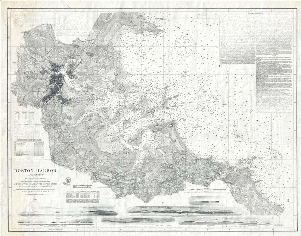
A fine separate issue first edition of the 1867 United States Coast Survey nautical chart or maritime map of Boston Harbor. Depicting Boston Harbor from Medford and Cambridge Observatory to Massachusetts Bay and from Lynn Harbor to Weymouth Landing, this beautiful map represents the 'end of an era' for the United States Coast Survey.
The Chart
Highly detailed and meticulously engraved, myriad depth soundings fill Boston Harbor and Massachusetts Bay (this map was originally created to be used on board ships as a navigation aid). Islands, peninsulas, and points are labeled, along with numerous bays and a handful of beaches, such as Nantasket Beach and Chelsea Beach. The city of Boston immediately jumps off the map since the city's dense network of roads and buildings appear darker color than the remainder of the chart. In addition to Boston proper, Cambridge, Charlestown, Chelsea, and other smaller towns are labeled. Solid black lines represent the railroads, such as the Boston, Hartford, and Erie Railroad, the Old Colony Rail Road, and the Boston and Maine Railroad. The Mystic River, the Charles River, and the Chelsea River are each identified.Views and Tables
Situated along the bottom border, several views allow the mariner to have a better understanding of what they would see when traveling this stretch of the coast. These views include the Boston Lighthouse as seen from the west-northwest, a view of Nix's Mate and the Deer Island Beacon, and several others. Tables containing information about lighthouses, tidal currents, and tides are included on the lower left, while a set of remarks on the set of the tidal currents is situated along the top border. Sailing directions and ranges for the region are included in the upper right corner.Publication History and Census
This chart was issued in 1867 copper plate of the United States Coast Survey nautical chart of Boston Harbor. There were many later reissues, often from the original plate, so it is impossible to distinguish between 19th century editions unless there have been updates. The chart was produced under the direction of A. D. Bache, the Superintendent of the Survey of the Coast of the United States, with triangulation, topography, and hydrography work completed by several teams of workers and their assistants.CartographerS
The Office of the Coast Survey (1807 - present) founded in 1807 by President Thomas Jefferson and Secretary of Commerce Albert Gallatin, is the oldest scientific organization in the U.S. Federal Government. Jefferson created the "Survey of the Coast," as it was then called, in response to a need for accurate navigational charts of the new nation's coasts and harbors. The spirit of the Coast Survey was defined by its first two superintendents. The first superintendent of the Coast Survey was Swiss immigrant and West Point mathematics professor Ferdinand Hassler. Under the direction of Hassler, from 1816 to 1843, the ideological and scientific foundations for the Coast Survey were established. These included using the most advanced techniques and most sophisticated equipment as well as an unstinting attention to detail. Hassler devised a labor intensive triangulation system whereby the entire coast was divided into a series of enormous triangles. These were in turn subdivided into smaller triangulation units that were then individually surveyed. Employing this exacting technique on such a massive scale had never before been attempted. Consequently, Hassler and the Coast Survey under him developed a reputation for uncompromising dedication to the principles of accuracy and excellence. Unfortunately, despite being a masterful surveyor, Hassler was abrasive and politically unpopular, twice losing congressional funding for the Coast Survey. Nonetheless, Hassler led the Coast Survey until his death in 1843, at which time Alexander Dallas Bache, a great-grandson of Benjamin Franklin, took the helm. Bache was fully dedicated to the principles established by Hassler, but proved more politically astute and successfully lobbied Congress to liberally fund the endeavor. Under the leadership of A. D. Bache, the Coast Survey completed its most important work. Moreover, during his long tenure with the Coast Survey, from 1843 to 1865, Bache was a steadfast advocate of American science and navigation and in fact founded the American Academy of Sciences. Bache was succeeded by Benjamin Pierce who ran the Survey from 1867 to 1874. Pierce was in turn succeeded by Carlile Pollock Patterson who was Superintendent from 1874 to 1881. In 1878, under Patterson's superintendence, the U.S. Coast Survey was reorganized as the U.S. Coast and Geodetic Survey (C & GS) to accommodate topographic as well as nautical surveys. Today the Coast Survey is part of the National Oceanic and Atmospheric Administration or NOAA as the National Geodetic Survey. More by this mapmaker...
Alexander Dallas Bache (July 19, 1806 - February 17, 1867) was an American physicist, scientist and surveyor. Bache is best known in cartographic circles as the Superintendent of the U.S. Coast Survey from 1843 to 1865. Born in Philadelphia, Bache, a great grandson of the statesman and inventor Benjamin Franklin, had a varied career primarily focused on education. He toured Europe on behalf of Girard College and composed an important treatise on European Education. Later he served as president of Philadelphia's Central High School and was a professor of natural history and chemistry at the University of Pennsylvania. On the death of Ferdinand Rudolph Hassler, Bache was appointed Superintendent of the United States Coast Survey. Picking up where Hassler left off Bache presided over the Survey during its most prolific period and oversaw the mapping of most of the United States coastline. To this day his name appears on countless marine pilot books and U.S. Coast Survey nautical charts. For his work he was elected Associate Fellow of the American Academy of Arts and Sciences, a Fellow of the Royal Society of Edinburgh, and a Foreign Member of the Royal Society. Following the Civil War, Bache was elected a 3rd Class Companion of the Military Order of the Loyal Legion of the United States. He died at Newport, Rhode Island and was buried in the Congressional Cemetery in Washington, DC, where he is commemorated with a monument built by American architect Henry Hobson Richardson. Learn More...
Condition
Very good. Even overall toning. Original plate mark visible. Blank on verso.