
This item below is out of stock, but another example (left) is available. To view the available item, click "Details."
Details
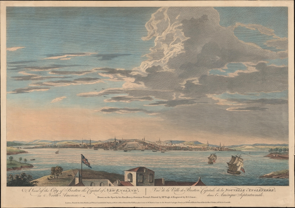
1768 Pownall View of Boston, Massachusetts
$6,500.00
1768 Pownall View of Boston, Massachusetts
BostonView-pownall-1768$2,750.00

Title
A View of the City of Boston the Capital of New England, in North America. / Vue de la Ville de Boston Capitale de la Nouvelle Angleterre, dans l'Amérique Septemtrionale.
1768 (undated) 14.75 x 21 in (37.465 x 53.34 cm)
1768 (undated) 14.75 x 21 in (37.465 x 53.34 cm)
Description
This is the rare Thomas Pownall view of Boston, published in 1768. It is one of the earliest obtainable views of Boston offering a look at the city shortly after the French and Indian War (1754 - 1763).
The publication of the Scenographia marked a sea change in the European sensibilities and perspectives on America. While America's dense forests, rugged mountains, endless plains, and enormous rivers were understood from a strategic and commercial perspective, little weight was given to their stunning visual appeal. While many celebrate the Hudson River School of the 19th century as bringing America's natural beauty to the forefront of the art world, it was in fact recognized much earlier. Well educated French and British officers, engineers, and nobility sent to fight the French and Indian War (1754 - 1763) were rightly sensitive to the beauty around them and recorded it with passion, but visually and in textual missives. Scenographia consolidated these impressions into series of compelling and evocative engraved images.
A Closer Look
The view looks northwest on Boston from Castle William, across the harbor. From left, coverage embraces South Cove, South Battery, Fort Hill, and Long Wharf. In the background the heights of Trimontane (Beacon Hill), are visible. In the foreground two British ships under full sail ply the deep-water channel between Castle and Governor's Islands. The British flag, proudly fling above Castle William, is prominent.'Scenographia Americana'
The view is part of a series of 28 images of American subjects known collectively as Scenographia Americana, a joint project involving many of London's top printers, engravers, and publishers. The individual drawings, including cities, seascapes, and natural scenes, were generally drawn on the spot, by military artists and surveyors, most serving in the French and Indian War (1754 - 1763) - like Pownall. The full Scenographia Americana is an object of legendary rarity, with only a single example (Christies, 2022) appearing at auction in the last 30 years.The publication of the Scenographia marked a sea change in the European sensibilities and perspectives on America. While America's dense forests, rugged mountains, endless plains, and enormous rivers were understood from a strategic and commercial perspective, little weight was given to their stunning visual appeal. While many celebrate the Hudson River School of the 19th century as bringing America's natural beauty to the forefront of the art world, it was in fact recognized much earlier. Well educated French and British officers, engineers, and nobility sent to fight the French and Indian War (1754 - 1763) were rightly sensitive to the beauty around them and recorded it with passion, but visually and in textual missives. Scenographia consolidated these impressions into series of compelling and evocative engraved images.
Publication History and Census
The view was issued jointly by London's premier map and print publishers: John Bowles, Carington Bowles, Thomas Jefferys, Robert Sayer, and Henry Parker. It is based upon a field sketch by Thomas Pownall (1722 - 1805), the British colonial governor of the Massachusetts Bay Colony from 1757 to 1760. The original sketch was made into a painting by the Irish landscape artist Herbert Pugh (1735 - 1788), before being engraved by Peter Charles Canot, one of the finest engravers then active in London. The Boston view was issued separately c. 1761, as well as in the 1768 first edition of Scenographia. Rare. Of the full Scenographia, we are aware of only six surviving examples, four in the U.S., another in England, and a sixth in private hands. The separate plates, some having been issued independently are somewhat better represented institutionally.CartographerS
Thomas Pownall (1722 - February 5, 1805) was a British scholar, statesman and soldier active in the colonial administration of North America just prior to the American Revolutionary War. Pownell was born in England and educated at Trinity College, Cambridge. After graduation he was employed by his brother, John Pownall, at the office of the Lord's Commissioners of Trade and Plantations, which oversaw British economic interests in its North American colonies. In 1753, Pownall was appointed secretary to the governor of New York, Sir Danvers Osborne. Osborne, himself having be only recently appointed to the position, committed suicide shortly after taking office. Despite this setback, Pownall remained in America and devoted himself to studying and researching the colonies. In the process Pownall became close lifelong friends with Benjamin and other New World luminaries. He also published several notable works on the colonial administration of North America. In 1757 Pownall was appointed Governor of the Massachusetts Bay colony. In this position he frequently found himself at odds with the restrictive policies of the Board of Trade. It was not long before he was pushed out of office and, declining the governorship of Jamaica, reassigned to South Carolina. Despite nominally holding the governorship of South Carolina, Pownall never visited the colony. Instead he returned to England where he eventually became a member of Parliament. In Parliament, he advocated for reduced taxes towards the colonies - had he been heeded, the American Revolution may have never happened. Pownall retired from public life around 1780, but continued to pursue his scholarly interests. Pownall's research contributed significantly to several important maps and scholarly work on North America. More by this mapmaker...
Pierre-Charles Canot (1714 - February 27, 1777) was a French engraver active in London in the mid-18th century. Canot was born in Paris, France, the son of intaglio printer Charles Canot and brother of landscape painter Philippe Canot (1715-1783). Canot was arrested in December 1740, along with several others, supposed for his part in printing a scandalous almanach érotique. He was released after a few months, and having found Paris 'uncomfortable', he relocated in 1741 to England, remaining there for the remainder of his life. From 1770, he was an associate engraver at the Royal Academy. He is known for landscapes, port views, seascapes, and various maritime subjects, but also produced some remarkable satirical pieces. He had at least one apprentice, Christopher Norton (17?? - 1799). Canot died in Kentish Town, London, apparently due to working himself to death on a series of engraved plates of the Russian fleet against the Turks after Paton. There is no complete inventory of his work, but the art critic and historian Charles Blanc (1813 - 1882) estimated that he produced about 175 pieces. (Bénézit, E., Dictionnaire critique et documentaire des Peintres, Sculpteurs, Dessinateurs et Graveurs, France: Librairie Gründ, 1966. Vol. 1, p. 113; Vol. 2, p. 295.) Learn More...
The Bowles Family (fl. c. 1714 - 1832) were publishers and map sellers active in London from c. 1714 to c. 1832. The firm, under Thomas Bowles (fl. 1714 - 1763), John Bowles (1701 - 1779), Carrington Bowles (1724 - 1793), and as Bowles and Carver (fl. 1794 - 1832), produced a massive corpus of work that included numerous atlases, pocket maps, and wall maps. The Bowles publishing tradition was kept alive for four generations, starting with Thomas Bowles, a print engraver active in the late 17th century. His son, Thomas Bowles II, produced the firm's first maps at St. Paul's Churchyard, London. Thomas's brother, John Bowles (a.k.a. 'Old John Bowles' or 'Black Horse Bowles'), was also an active publisher established at no. 13 Cornhill. He is credited as one of the first publishers of William Hogarth's works. There, John's son, Carrington Bowles, was introduced to the trade. Carrington took over the Cornhill bookshop and eventually merged it with his uncle's shop in St. Paul's Churchyard. On Carrington's 1793 death, the business was passed to his son Henry Carrington Bowles (1763 - 1830), who partnered with his father's former apprentice Samuel Carver (1756 - 1841), renaming the firm 'Bowles and Carver'. Under this imprint, the firm continued to publish maps and atlases until 1832. Henry Carrington Bowles died in 1830, but Samuel Carver, himself in advanced years and poor health, kept it going for another 2 years before closing the business. Learn More...
Robert Sayer (1725 - January 29, 1794) was an important English map publisher and engraver active from the mid to late 18th century. Sayer was born in Sunderland, England, in 1725. He may have clerked as a young man with the Bank of England, but this is unclear. His brother, James Sayer, married Mary Overton, daughter-in-law of John Overton and widow of Philip Overton. Sayer initially worked under Mary Overton, but by December of 1748 was managing the Overton enterprise and gradually took it over, transitioning the plates to his own name. When Thomas Jefferys went bankrupt in 1766, Sayer offered financial assistance to help him stay in business and, in this way, acquired rights to many of the important Jefferys map plates as well as his unpublished research. From about 1774, he began publishing with his apprentice, John Bennett (fl. 1770 - 1784), as Sayer and Bennett, but the partnership was not formalized until 1777. Bennett retired in 1784 following a mental collapse and the imprint reverted to Robert Sayer. From 1790, Sayer added Robert Laurie and James Whittle to his enterprise, renaming the firm Robert Sayer and Company. Ultimately, Laurie and Whittle partnered to take over his firm. Sayer retired to Bath, where, after a long illness, he died. During most of his career, Sayer was based at 53 Fleet Street, London. His work is particularly significant for its publication of many British maps relating to the American Revolutionary War. Unlike many map makers of his generation, Sayer was a good businessman and left a personal fortune and great estate to his son, James Sayer, who never worked in the publishing business. Learn More...
Thomas Jefferys (1695 - November 20, 1771) was one of the most prominent and prolific map publishers and engravers of his day. Jefferys was born in Birmingham and was apprenticed to the engraver Emmanuel Bowen in 1735. Later, in the 1740s he engraved several maps for the popular periodical Gentleman's Magazine. Around 1740 Jefferys was finally able to go into business for himself and in 1746 received an appointment as 'Geographer to Fredrick, Prince of Wales,' which shortly after translated to the position of 'Royal Cartographer to King George III.' Jefferys initially specialized in compiling and re-engraving the works of earlier cartographers into more coherent cartographic wholes. Later, while not salaried position, Jefferys' appointment as 'Royal Cartographer' guaranteed preferential access to the most up to date cartographic material available, allowing him to produce new and updated charts of exceptional accuracy. He his best known for his maps of the Americas, particularly the posthumously published 1775 American Atlas, which included some of the finest and most important late colonial era maps of America ever made. Despite his prolific publishing history, royal appointments, and international publishing fame, Jefferys lived most of his life in dire economic straits. He was bailed out of bankruptcy by Robert Sayer during the production of the American Atlas. In the end, Jefferys died suddenly with very little to his name. Nonetheless, his cartographic legacy survived, and even after his death in 1771, many of his important maps continued to be published and republished by Sayer and Bennet, Conrad Lotter, Georges Louis Le Rouge, Laurie and Whittle, and others. Many attribute some of Jefferys best maps to the colorful and criminally inclined Irish cartographic genius Braddock Mead (John Green, c. 1688 - 1757), who is considered the 'secret behind Jefferys.' Jefferys was succeeded by his son, also Thomas, who had little success as a cartographer and eventually partnered with, then sold his stock and plates to William Faden - Jefferys' true heir. Learn More...
Condition
Very good. Trimmed to just outside pressmark.
References
Library of Congress, Illus. in NE1714 .S4 (folio) [General Collections]. Deak, Gloria Gilda, Picturing America: 1497-1899, #106. Stokes, I. N. P, and Haskell, D. C., American Historical Prints, 1758-B-86. Winsor, Justin, Memorial History of Boston, page II:127.