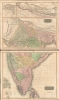
1817 Thomson Map of India with Nepal (set of 2 maps)
BritishIndia-thomson-1817-2$400.00


Title
British India, Northern Part. British India, Southern Part.
1817 (dated) 41 x 25 in (104.14 x 63.5 cm) 1 : 4400000
1817 (dated) 41 x 25 in (104.14 x 63.5 cm) 1 : 4400000
Description
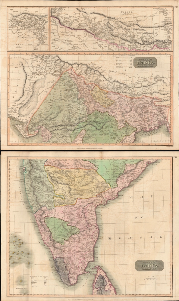
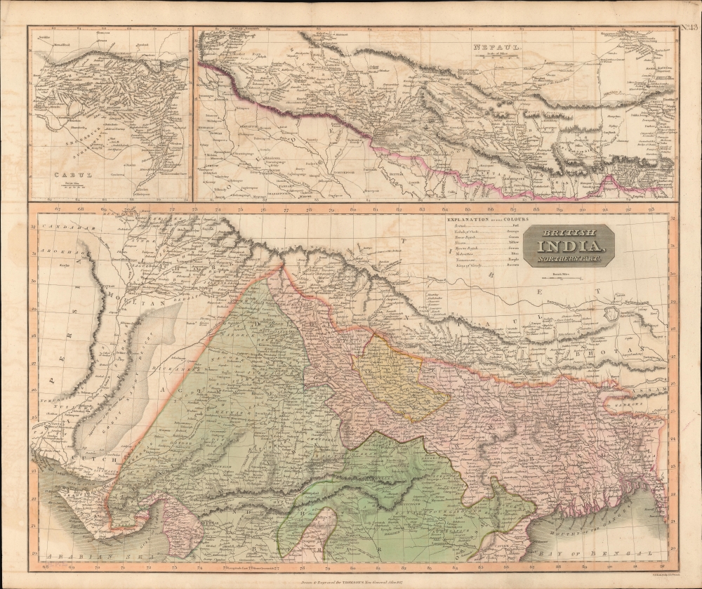
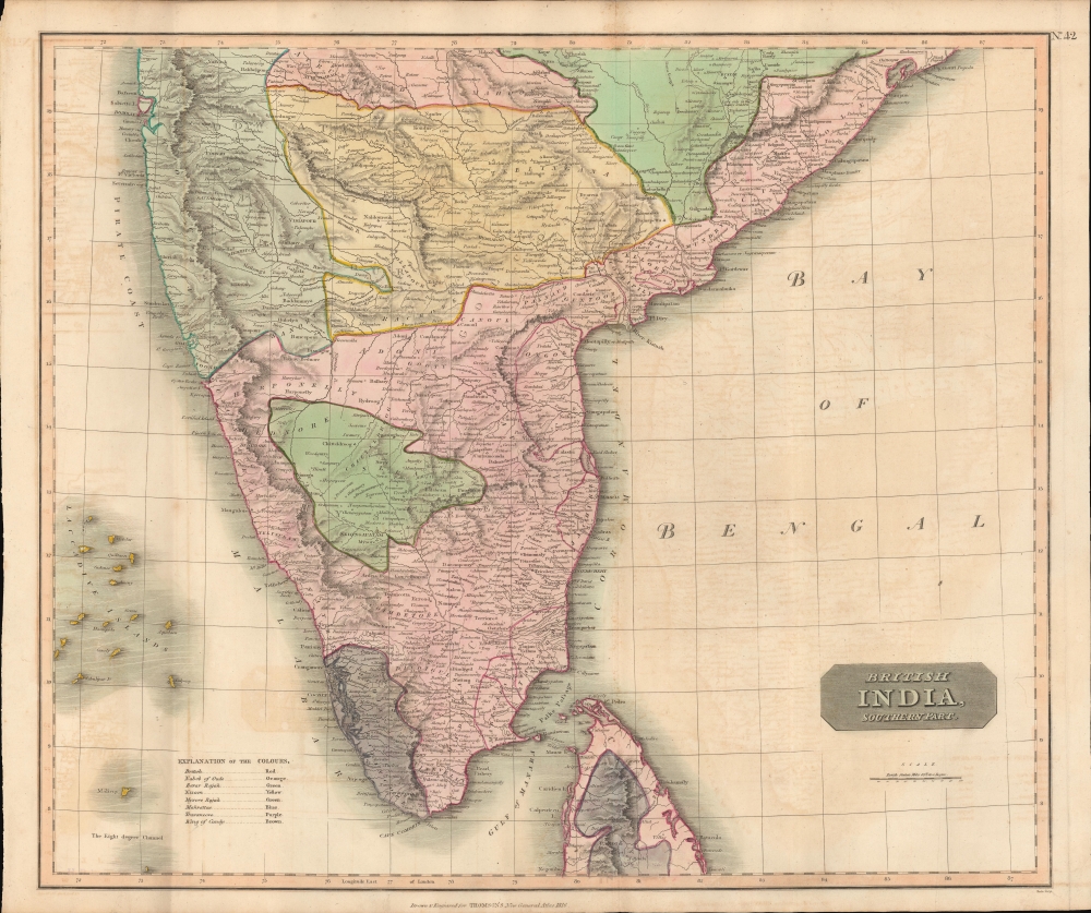
This is a stunning set of two 1817 maps of India and Nepal by Edinburgh cartographer John Thomson. As a whole, the maps illustrate India when the British East India Company had expanded their control - here in pink - from coast to coast. Color coding, with a key on the lower sheet, defines spheres of influence, including both British allies and enemies.
At top there is a large inset of the Kingdom of Nepal and a smaller inset of the vicinity of Kabul. This area is depicted in impressive detail considering that, when this map was printed very few western travelers had ever been to Nepal. Includes roads, mountain passes and the residences of important Lamas. Extends fully into the Tibetan plateau as far as Te Shoo Loomboo and the Road to Lhasa (Lassa).
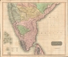
The second map (image bottom) covers southern India from Bombay to northern Ceylon. Many of these areas were at war with the British when this map went to press.
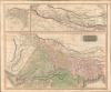
Upper Map
The upper map depicts northern India and Nepal bounded on the east by Persia and the Indus valley, on the North by Tibet, on the south by Berar, and on the east by Assam and Bhutan.At top there is a large inset of the Kingdom of Nepal and a smaller inset of the vicinity of Kabul. This area is depicted in impressive detail considering that, when this map was printed very few western travelers had ever been to Nepal. Includes roads, mountain passes and the residences of important Lamas. Extends fully into the Tibetan plateau as far as Te Shoo Loomboo and the Road to Lhasa (Lassa).
The second map (image bottom) covers southern India from Bombay to northern Ceylon. Many of these areas were at war with the British when this map went to press.
Publication History and Census
This map was published by John Thomson for the 1817 Baldwin, Cradock, and Joy edition of John Thomson's New General Atlas. The maps were engraved by Samuel John Neele.CartographerS
John Thomson (1777 - c. 1841) was a Scottish cartographer, publisher, and bookbinder active in Edinburgh during the early part of the 19th century. Thomson apprenticed under Edinburgh bookbinder Robert Alison. After his apprenticeship, he briefly went into business with Abraham Thomson. Later, the two parted ways, John Thomson segueing into maps and Abraham Thomson taking over the bookbinding portion of the business. Thomson is generally one of the leading publishers in the Edinburgh school of cartography, which flourished from roughly 1800 to 1830. Thomson and his contemporaries (Pinkerton and Cary) redefined European cartography by abandoning typical 18th-century decorative elements such as elaborate title cartouches and fantastic beasts in favor of detail and accuracy. Thomson's principle works include Thomson's New General Atlas, published from 1814 to 1821, the New Classical and Historical Atlas of 1829, and his 1830 Atlas of Scotland. The Atlas of Scotland, a work of groundbreaking detail and dedication, would eventually bankrupt the Thomson firm in 1830, at which time their plates were sequestered by the court. The firm partially recovered in the subsequent year, allowing Thomson to reclaim his printing plates in 1831, but filed again for bankruptcy in 1835, at which time most of his printing plates were sold to A. K. Johnston and Company. There is some suggestion that he continued to work as a bookbinder until 1841. Today, Thomson maps are becoming increasingly rare as they are highly admired for their impressive size, vivid hand coloration, and superb detail. More by this mapmaker...
Samuel John Neele (July 29, 1758 - May 13, 1824) was a prolific British map engraver active in the late 18th and early 19th centuries. Neele apprenticed as a printer and engraver with Harry Ashby from about 1781 to 1782 before establishing himself independently in 1785 at 352 Strand, London. The combination of business acumen and technical skill made Neele extremely successful with literally hundreds of maps to his credit. His vast corpus was composed of notable maps by most major English publishers of the period including, Haywood, Faden, Wallis, Stockdale, Arrowsmith, Thomson, Pinkerton, and Greenwood, among others. Neele's sons, James and Josiah Neele, also engravers, took over their fathers business around 1818, both becoming notable in their own right. Learn More...
Baldwin and Cradock (fl. c. 1810 - 1860) were London based publishers working in the early to mid 19th century. They are best known for their publication of the Society for the Diffusion of Useful Knowledge's ground breaking subscription atlas. They also published John Thomson's magnificent New General Atlas from 1814 - c. 1820. In addition to their cartographic corpus, the firm had wide ranging publishing interests in many other areas, including books, broadsides, and an investment in Blackwoods Magazine. They had their offices at 47 Paternoster Row, London, England. This firm also published under the imprint Baldwin, Cradock, and Joy and Cradock and Joy. Learn More...
Source
Thomson, J., A New General Atlas, (Edinburgh: Baldwin, Craddock, Joy) 1817.
Thomson's New General Atlas was first published in 1817 and continued to be published until about 1821. This is the first of Thomson's major cartographic works and the atlas for which is most celebrated. The New General Atlas follows in the Edinburgh School, which eschews excessive decoration in favor of a more minimalistic fact-based cartographic vision, as established by John Pinkerton, Laurie and Whittle, John Cary, and others in the previous decades. The maps are notable for their massive scale, heavy stock, elegant color work, and easy-to-read typefaces. Although the atlas stopped being published after 1821, Thomson continued to offer 'supplementary' maps that could be tipped into the atlas as late as 1830, when he declared bankruptcy. The maps in the Thomson Atlas were engraved by Thomas Clerk, William Dassauville, Nathaniel Rogers Hewitt, James Kirkwood, Robert Kirkwood, John Menzies, George Menzies, Edward Mitchell, John Moffatt, Samuel John Neele, Robert Scott, and James Wyld.
Condition
Very good. Set of two maps. Minor wear and verso repair along original centerfolds. Original platemarks visible. Foxing and toning at places. Size refers to the composite of two map. Individual maps are 22 x 25 in.
References
Rumsey 1007.045, 1007.046.