
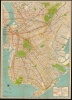
1934 George Nostrand Map of Brooklyn


This item has been sold.
Nostrand's Indexed Brooklyn House Number Map.
No Sleep 'Til...
- Digital Map Information
- Suitable for large format printing
- Full resolution TIFF file
- ICC color profile embedded
- Delivered instantly via download link
No Sleep 'Til...
This is George Nostrand's 1934 folding map of Brooklyn, New York.A Closer Look
The map ranges from Coney Island to Greenpoint, shows part of the Lower East Side, and extends east as far as Jamaica Bay. It displays the full array of city transit options: each of the three subway lines (Independent, B.M.T., and I.R.T.) is given symbols, with distinctions between express and local stations. In addition, the map shows the elevated railroads, bus lines, good auto routes, and the Long Island Rail Road. Parks and cemeteries - including Greenwood Cemetery and Cypress Hill - are marked. Floyd Bennett Field is labeled.Publication History
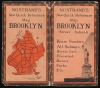
This map was created and published by George Nostrand. Cataloged examples are universally dated 1934, and the details of these maps agree with ours in most aspects. The covers, however, are different: ours illustrates the Statue of Liberty, while the cataloged examples feature the Brooklyn Bridge. We suspect a different publication year, but no corroborating evidence supports a specific date. We see no listed example corresponding to our cover.Cartographer
George J. Nostrand (fl. 1920 - 1940) was an American lithographer and publisher of maps and views, primarily of New York City. He appears to have been in the employ of the Arthur Ohman Map Co. until the firm’s closing. It is unclear when this happened exactly as some publications use Nostrand's name in the title but retain the Ohman imprint (August Ohman, founder of the Ohman Map Co., died in 1934). Thereafter, Nostrand operated from the same location under his own name as late as 1939. Further Details...
Condition
Very good. Mends at several junctures of folds with extremely minimal loss. Covers present but separate, inclusive of index.
References
OCLC 19970102.