This item has been sold, but you can get on the Waitlist to be notified if another example becomes available, or purchase a digital scan.
1786 La Perouse Map of San Francisco, Monterey Bay, California and Oregon
California-perouse-1786-2$200.00

Title
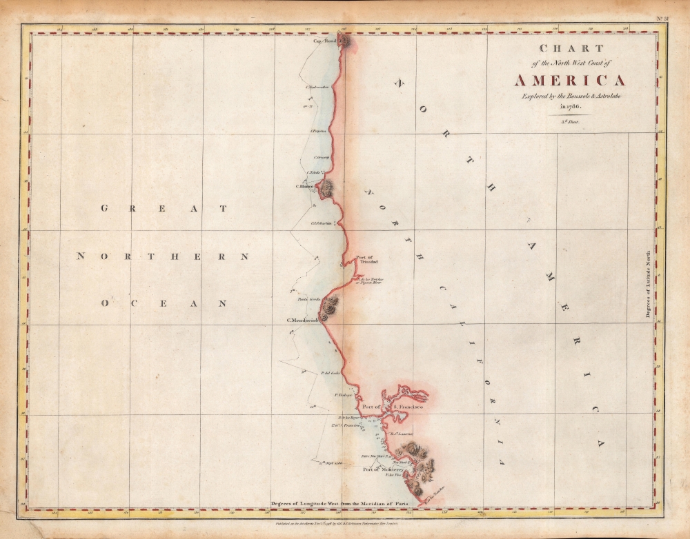
Chart of the North West Coast of America Explored by the Boussole and Astrolabe in 1786. 3rd Sheet.
1786 (dated) 15 x 19.75 in (38.1 x 50.165 cm) 1 : 3040000
1786 (dated) 15 x 19.75 in (38.1 x 50.165 cm) 1 : 3040000
Description
An important early chart of the coasts of Northern California and Oregon, undertaken by the ill-fated French voyage led by La Perouse in 1786. This rare hand-colored example of the map came from the first English edition of the text and plates recounting La Perouse's voyage, published in London by J. and G. Robinson in 1798.
Nonetheless, this map remains one of the earliest accurate charts of this coastline and is a vital addition to any serious collection focusing on the cartographic development of America's western coast. A rare map to begin with, this is an even scarcer hand-colored example. Regardless of coloration, the map is held by five institutions in North America (the University of California Berkeley, the University of Oregon, Reed College, the University of British Columbia, and the University of Toronto), while the entire Charts and Plates is cataloged among the holdings of around fifteen institutions worldwide.
A Closer Look
This is a fine example of La Perouse's important 1786 mapping of the California and Oregon coastlines from Port de Monterey (Monterey Bay) northwards past the Port de St. Francois (San Francsico Bay) and Cape Mendocino to Cap Rond (Tillamook Head, Oregon). Although minimalistic, this map exhibits one of the most important early surveys of San Francisco Bay. La Perouse spent roughly ten days surveying San Francisco Bay making numerous improvements over Jose de Canizares' 1776 Plano del Puerto de Sn. Francisco. Skirting the coast, La Perouse also identifies several important landmarks including Bodega Bay (P. Bodega), Cape Mendocino, Port de La Trinite, Cap Blanc (Cape Blanco), and others. The route and dates of the La Perouse expedition are noted as it progresses down the coast.Publication History and Census
This map was based on La Perouse's sketches and was published in London by J. and G. Robinson in 1798, in the work Charts and Plates to la Perouse's Voyage, the first English-language recounting of La Perouse's voyage. Though not listed here, the engraver was very likely Samuel John Neele, who engraved the other maps and plates in the Charts and Plates. In its day, the importance of this chart went largely unknown as the atlas of La Perouse's discoveries was not officially published until 1798, after the voyage had been recognized as lost and the journals it had sent en route were considered safe to share with the public. However, by that time, other more advanced mappings of the region had been distributed throughout Europe.Nonetheless, this map remains one of the earliest accurate charts of this coastline and is a vital addition to any serious collection focusing on the cartographic development of America's western coast. A rare map to begin with, this is an even scarcer hand-colored example. Regardless of coloration, the map is held by five institutions in North America (the University of California Berkeley, the University of Oregon, Reed College, the University of British Columbia, and the University of Toronto), while the entire Charts and Plates is cataloged among the holdings of around fifteen institutions worldwide.
CartographerS
Jean François de Galaup, Comte de La Pérouse (August 23, 1741 - 1788) was a French naval officer, navigator, and explorer active in the later part of the 18th century. Born into a noble family of Albi, France, La Perouse entered the navel college of Brest at just 15. At seventeen La Perouse made his first naval voyage, a supply expedition to the fort of Louisbourg in New France. He later participated in a number of naval battles, mostly against the English, and eventually rose to the rank of Commodore. In 1782 he captured the English forts Prince of Wales and York, making a name for himself back in France. Following the British defeat at the end of the American Revolutionary War, La Perouse was appointed by Louis XVI to lead an expedition of discovery circumnavigating the globe. The goal of the expedition was to complete and correct the maps of the Pacific drawn by Captain Cook. La Perouse's two frigates, the Astrolabe and the Boussole rounded Cape Horn and entered the Pacific in 1785. Crisscrossing the Pacific from Macau and Japan to Alaska, Vancouver, and the Hawaiian Islands Perouse made numerous discoveries and adding considerably to the cartographic corpus, particularly along the coast of British Columbia and around Japan. In Australia La Perouse sent his last letter back to France containing all of his maps and research. Tragically, on the return voyage La Perouse ran into a violent storm which left both of his frigates shipwrecked on the Polynesian island of Vanikoro, part of the Santa Cruz Group. Some of the survivors of the shipwrecks seem to have managed to live on the island for years afterwards. As late as 1790 the English Captain Edward Edwards saw smoke signals coming from Vanikoro but foolishly declined to investigate. Expeditions in 2005 and in 2008 identified the remains of both ships and retuned numerous artifacts from the ill-fated expedition to France. The importance of La Perouse's discoveries was, unfortunately, not seriously appreciated until many years later because, when the La Perouse maps were finally published in 1797, newer more accurate maps of the region were already in circulation. Nonetheless, La Perouse remains of the titans of Pacific exploration and he work paved the path forward for all future expeditions to the region. More by this mapmaker...
G. and J. Robinson (fl. 1785 - 1818) were Scottish book, magazine, and map publishers active in the late 18th and early 19th centuries. The firm was based at 25 Paternoster Row, London. From about 1809, it was run exclusively by G. Robinson. The firm, at various points, consisted of George Robinson (the elder) the 'King of Booksellers', George Robinson (the younger), John Robinson, and James Robinson. It was George Robinson, the younger, who continued to run the firm solo after 1909. Learn More...
Samuel John Neele (July 29, 1758 - May 13, 1824) was a prolific British map engraver active in the late 18th and early 19th centuries. Neele apprenticed as a printer and engraver with Harry Ashby from about 1781 to 1782 before establishing himself independently in 1785 at 352 Strand, London. The combination of business acumen and technical skill made Neele extremely successful with literally hundreds of maps to his credit. His vast corpus was composed of notable maps by most major English publishers of the period including, Haywood, Faden, Wallis, Stockdale, Arrowsmith, Thomson, Pinkerton, and Greenwood, among others. Neele's sons, James and Josiah Neele, also engravers, took over their fathers business around 1818, both becoming notable in their own right. Learn More...
Source
Robinson, G. G. and J., Charts and Plates to La Perouse's Voyage, 1798.
Condition
Good. Darker toning at top margin. repaired tear at bottom-left. Some discoloration along the fold line.
References
Rumsey 0414.031, OCLC 24184140.