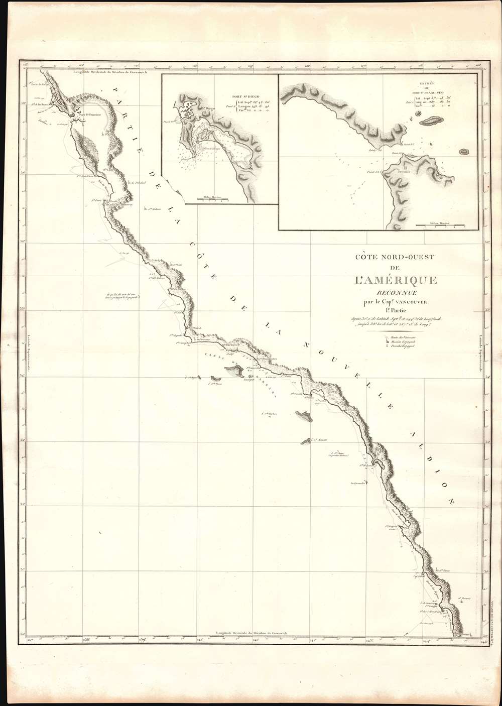
1799 Vancouver Map of the California Coast w/ San Francisco and San Diego
CaliforniaCoast-vancouver-1799-2$1,500.00

Title
Cote Nord-Ouest de L'Amerique Reconnue par le Cape. Vancouver. 1e Partie.
1799 (undated) 31 x 25 in (78.74 x 63.5 cm)
1799 (undated) 31 x 25 in (78.74 x 63.5 cm)
Description
One of the great navigator George Vancouver's most important and influential maps, this is his 1799 charting of the California coastline roughly from Santo Domingo, Mexico, to San Francisco Bay. Vancouver's exploration of the California coastline was significant, breaking the Spanish wall of silence and producing the first English reconnaissance on Spanish settlement and colonization of the West Coast. Vancouver's mapping of California generated the finest coastal chart of the region to date.
A Wall of Silence and Suspicion
Until the arrival of George Vancouver, California was a mystery to all Europeans except the Spanish, who hid knowledge of it behind a wall of secretive suspicion. Although Spanish explorers and missionaries knew of California's bounty, other than a few missions and the Presidio Fort at San Francisco, the Spanish did very little to develop or settle the region. The lack of general colonization may have been because California remained remote, or because it had a large indigenous population, or because both Spain and England laid amorphous ill-defined claims. Spanish claims dated to the conquest of Mexico by Cortez during the Spanish-Aztec War (1519 - 21), while British claims date to the 1579 voyage of Francis Drake and his naming of California as Nova Albion. Spain only had to look to the British colonization of the eastern seaboard to know that if the potential of California became known, the British model of colonization would sideline their own interests.Vancouver in San Diego
When the Englishman Vancouver sailed into San Diego Harbor, there can be little doubt he believed he was looking on Nova Albion - and that the Spanish were interlopers. Whatever his beliefs, Vancouver was among the first foreigners to visit and map San Diego (see inset). He was not impressed, describing it as 'indolent,' 'poor,' and 'dreary.' As he sailed up the coast, he visited a host of other Spanish missions, including San Juan, San Gabriel, San Buenaventura, Santa Barbara, La Purissima, San Louis, San Antonio, Santa Carlos del Monterrey, La Soledad, Santa Cruz, and Santa Clara.Vancouver in San Francisco
On November 14, 1792, Vancouver became the first Englishman to pass the Golden Gate and enter San Francisco Bay (upper right inset). However, he admittedly did little cartographic work there. Nonetheless, Alcatraz Island, Angel Island, Peninsula Point, and Tiburon are recognizable. The Presidio that would one day evolve into San Francisco appears in the upper right inset. Likely, Vancouver did not press into San Francisco Bay as the primary objectives of his voyage were further north, and by mid-November, it was already getting cold. A prolonged stop to map San Francisco Bay would have delayed his objectives until the following spring.Publication History and Census
This example of Vancouver's map was issued in the highly desirable 1799 French edition of Vancouver's atlas, which is noted for being more beautifully produced with better engraving, higher quality paper, and more detail than the 1798 English edition. None of the maps list an engraver, but the atlas's introductory text states that they were engraved at the Dépôt des Cartes et Plans de la Marine under the supervision of Jean-Nicholas Buache de Neuville. This scarce map is a core piece for any serious collection focusing on California, Vancouver, British Columbia, or the Pacific Northwest.CartographerS
George Vancouver (June 22, 1750 - May 10, 1798) was a British naval officer and explorer active in the late 18th century. Vancouver was the last of the great naval explores of the 18th century and, along with Captain James Cook and Perouse, is credited with the first accurate mapping of the Northwest Coast of America. Vancouver was born in King's Lynn, England and joined the Royal Navy at age 13 as a seaman. While little is known of Vancouver's early life, he first appears in the annals of history as a midshipmen aboard the HMS Resolution of Captain Cook's second voyage in search of Terra Australis. On this expedition Vancouver claimed to have "been nearer the south pole than any other man" (after climbing the bowsprit before the ship turned back in the face of mountains of Antarctic ice). He also accompanied the third Cook expedition as a midshipman on the HMS Discovery where he witnessed the discovery of the Hawaiian Islands as well as Cooks tragic death on those same islands. Returning to England under Cook's second, Captain Clerke recommended Vancouver for promotion to Lieutenant. Under his new commission he spent several years learning surveying in the Caribbean aboard the HMS Martin, where he also distinguished himself in a number of military altercations with the French. In 1790 Vancouver received an appointment as the Captain of the HMS Discovery and was commissioned to complete the exploration of American's Northwest Coast begun by Cook and Perouse. Between 1791 and 1795 Vancouver's remarkable diligence and attention to detail created the first truly accurate cartographic picture of the American Coast between San Francisco Bay and California. Vancouver was the first to map countless rivers and inlets and to identify Vancouver Island. During his four years of exploration he also spent three winters in Hawaii, creating in the process the first accurate map of the islands. Unlike many earlier explorers Vancouver generally maintained good and respectful relations with the indigenous peoples he encountered. In Hawaii Vancouver allegedly negotiated the cession of Hawaii to England as well as introduced beneficial flora and fauna to the archipelago. Vancouver returned to England in 1795 where he immediately ran afoul of the powers that be. During his voyages Vancouver excited the ire of more than one crew member, including the well-connected naturalist Archibald Menzies, the sailing master Joseph Whidbey, and Thomas Pitt, the powerful Baron of Camelford. Slandered and assaulted by these influential enemies, one of Britian's greatest explorers fell into obscurity. He died shortly after in 1798 and was buried in an unremarkable grave at St. Peter's Churchyard, Petersham, Surrey, England. The journals of Vancouver's expedition, as well as his all-important maps, were published posthumously in the same year as his death. Robin Fisher, the academic Vice President of Mount Royal University in Calgary and author of two books on Vancouver, writes: He [Vancouver] put the northwest coast on the map...He drew up a map of the north-west coast that was accurate to the 'nth degree,' to the point it was still being used into the modern day as a navigational aid. That's unusual for a map from that early a time.
Today Vancouver is memorialized by Vancouver Island, which he discovered, the Hudson Bay Company's Fort Vancouver, the city of Vancouver, Vancouver Peninsula Australia, Mount Vancouver, the 8th highest mountain in Canada, Vancouver Bay in Jervis Inlet, and the Vancouver Maritime Museum. For his 250th birthday, the Canada Post issued a special postage stamp in his honor. More by this mapmaker...
Dépôt des Cartes et Plans de la Marine (fl. 1720 - present), often called the Dépôt de Marine, was a French hydrographic mapping organization founded in 1720 under Charles-Hercule of Albert de Luynes (1674 - 1734). Much like the U.S. Coast Survey, the British Admiralty, and the Spanish Deposito Hydrografico, the Dépôt was initiated as a storehouse and distribution center of existing nautical and marine charts. Eventually the Dépôt initiated its own mapping activities in an attempt to improve and expand upon existing material. Some of the more prominent cartographers and hydrographers associated with the of Dépôt des Cartes were, Philippe Buache, Jacques-Nicholas Bellin, Giovanni Rizzi-Zannoni, Rigobert Bonne, and Jean Nicolas Buache. Learn More...
Jean-Nicholas Buache de Neuville (February, 15 1741 - November 21, 1825) was a French geographer, cartographer, scientist, and map publisher active in late 18th century Paris. Buache de Neuville was the nephew of the more prominent French geographer Philippe Buache, who held the coveted post of Premier Geographe du Roi. The position meant that Philippe Buache was assigned to tutor the young Dauphin in Geography. Philippe Buache often brought his young nephew, Jean-Nicholas Buache to these secessions where he apparently developed an excellent relationship with the prince. After Philippe Buache's death in 1773 the position of Premier Geographe du Roi fell to J. B. B. D'Anville, who himself died in 1782. Jean-Nicholas Buache, now 41, was in an ideal position to take up the job and canvased his royal friend, now Louis XVI for the position. He became the Premier Geographe du Roi in 1782, beating out such strong competitors as Rigobert Bonne, Didier Robert de Vaugondy, and Edmonde Mentelle. Buache de Neuville compiled maps based upon geographic knowledge, scholarly research, the journals of contemporary explorers and missionaries, and direct astronomical observation. Nevertheless, even in 18th century Paris geographical knowledge was severely limited - especially regarding those unexplored portions of the world, including the poles, the Pacific northwest of America, and the interior of Africa and South America. In these areas Buache de Neuville, like his uncle, Philippe, and primary rival Robert de Vaugondy, must be considered a speculative geographer or 'positive geographer'. Speculative geography was a genre of mapmaking that evolved in Europe, particularly Paris, in the middle to late 18th century. Cartographers in this genre would fill in unknown areas on their maps with speculations based upon their vast knowledge of cartography, personal geographical theories, and often dubious primary source material gathered by explorers and navigators. This approach, which attempted to use the known to validate the unknown, naturally engendered many rivalries. Buache de Neuville's feuds with other cartographers, most specifically Didier Robert De Vaugondy, resulted in numerous conflicting papers being presented before the Academie des Sciences, of which both were members. The era of speculatively cartography effectively ended with the late 18th century explorations of Captain Cook, Jean Francois de Galaup de La Perouse, and George Vancouver. Learn More...
Source
Baker, J., and Vancouver, G., Voyage de decouvertes a l'ocean Pacifique du Nord, et autour du monde, (Paris: Imprimerie de la République) 1799.
Condition
Very good. Original centerfold. Platemark visible.
References
Rumsey 0233.005 (English edition). National Maritime Museum. Catalogue, 256.