
1953 Pictorial Tourist Map of Cannes, France

This item has been sold.
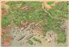
Relief Map of Cannes and surrounding country. / Carte en Relief de Cannes et Environs.
'How this coast smells of riches!' - Jane de Glehn
Choose a Collection:
- Digital Map Information
- Suitable for large format printing
- Full resolution TIFF file
- ICC color profile embedded
- Delivered instantly via download link
This Item
Enquire
'How this coast smells of riches!' - Jane de Glehn
This is a 1953 pictorial map of Cannes, Côte d'Azur, France. World famous as the host of the Cannes Film Festival, Cannes appears just below center with its celebrated beaches and harbor on full display. Vacationers sunbathe on the beaches and sail and paddle-board in the bay. More vacationers waterski and enjoy the fine weather in the Golfe Juan not far from Juan les Pins and Antibes, two other popular French Riviera resort towns. Villages interspaced with lavender fields dot the landscape inland.Verso Content
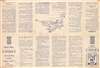
A wealth of tourist information in English and French occupies the verso. A plan of the city appears at center with twenty locations numerically identified, referencing to a textual list of 'helpful addresses'. The rest of the text suggests day trips, including to Antibes, Juan les Pins, St. Cézaire, and the Gorges du Loup.Publication History and Census
This map was drawn by an individual known only by the initials 'D. H. B.' It was printed in Cannes in 1954. This map is not cataloged in OCLC and we have not located any other examples.Condition
Very good. Exhibits light wear along original fold lines.