
1627 John Speed County Map of Cardiganshire

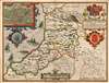
Cardigan Shyre Described with the due forme of the Shiretown as it was surveyed by I.S. Anno 1610.
Key Border County Between England and Wales.
- Digital Map Information
- Suitable for large format printing
- Full resolution TIFF file
- ICC color profile embedded
- Delivered instantly via download link
Key Border County Between England and Wales.
This is John Speed's map of the county of Cardiganshire, Wales. Engraved in 1608, this map was included in a 1627 edition of Speed's The Theatre of the Empire of Great Britaine. While many of Speed's maps were derived from the work of Christopher Saxton, this one was founded on Speed's own surveys. The map is beautifully engraved - this, the work of Jodocus Hondius - and identifies the county's towns, major villages, and its five hundreds of Genau'r-Glyn (Llanbadarn on the map), Ilar (Llanylar), Moyddyn, Penarth and Troedyraur. Rivers are marked and named. The region's mountainous terrain is indicated pictorially, with special emphasis placed on 'Plinillimon Hill' - that is to say, Plynlimon or Pen Pumlumon Fawr, the highest point of the Cambrian Mountains in Wales, and the source of the rivers Severn, Wye and Rheidol. (The headwaters of these rivers are all shown.)Other Details
The map's cartouche is decorated with the Royal Arms and those of the Princes of Wales. The feather badge of the Prince of Wales decorates the fine compass rose in Cardigan Bay - whose waters are patrolled by three fine sailing ships, and menaced by two extraordinary sea monsters. An inset plan in the upper left details the town of Cardigan on the banks of the River Teifi. High Street, Church Street, and 'Souter's Street' are labeled on the map. The Castle and castle bridge are shown but not named. St. Mary's Church is shown, but labeled 'The Colledg.'Ceredigion
In the second half of the first millennium, Ceredigion was a minor kingdom in its own right, but has been administered as a county since Edward I's conquest of the principality of Wales in 1282. It remains a center of Welsh culture.Publication History and Census
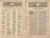
This map was engraved by Jodocus Hondius in 1608 for inclusion in John Speed's The Theatre of the Empire of Great Britaine, published in London by Sudbury and Humble in 1614. It continued in publication in the atlas in all its editions, including those that were bound together with Speed's A Prospect of the Most Famous Parts of the World. This example bears the Sudbury and Humble imprint, and typographically corresponds to 1627 editions of the Prospect. Perhaps twenty-nine examples of the separate map, in various editions, appear in institutional collections.Cartographers
John Speed (1542 - 1629) was an important English historian and cartographer active in the early 17th century. Speed was born in Fardon, Cheshire and apprenticed under his father as a tailor. Though his heart was never in tailoring, Speed dedicated himself to this profession until he was about 50 years old. During all the time, Speed dedicated his spare time to research as amateur historian and mapmaker - even preparing several maps for Queen Elizabeth. In London, Speed's interest in history lead him to join the Society of Antiquaries. Eventually he befriended the wealthy Sir Fulke Greville, who sponsored his researches and eventually freed him from the haberdashery profession. Working with William Camden, Speed eventually published his 1611 Historie of Great Britaine. Though this history itself was amateurish and of minimal importance, Speed's inclusion of numerous maps of British Cities and town was seminal. In many cases these plans were the first maps ever issued of their respective subjects. Later, turning his attention more fully to Geography, Speed published the magnificent atlas Theatre of the Empire of Great Britaine and, just prior to his death, the 1627 A Prospect of the Most Famous Parts of the World. These were the first British world atlases and have a landmark position in the history of cartography. These atlases continued to be published well after Speed's death. Further Details...
Jodocus Hondius (October, 14 1563 - February 12, 1612) was an important Dutch cartographer active in the late 16th and early 17th centuries. His common name, Jodocus Hondius, is actually a Latinized version of his Dutch name, Joost de Hondt. He is also sometimes referred to as Jodocus Hondius the Elder to distinguish him from his sons. Hondius was a Flemish artist, engraver, and cartographer. He is best known for his early maps of the New World and Europe, for re-establishing the reputation of Gerard Mercator, and for his portraits of Francis Drake. Hondius was born and raised in Ghent. In his early years, he established himself as an engraver, instrument maker, and globe maker. In 1584, he moved to London to escape religious difficulties in Flanders. During his stay in England, Hondius was instrumental in publicizing the work of Francis Drake, who had circumnavigated the world in the late 1570s. In particular, in 1589, Hondius produced a now-famous map of the cove of New Albion, where Drake briefly established a settlement on the west coast of North America. Hondius' map was based on journals and eyewitness accounts of the trip and has long fueled speculation about the precise location of Drake's landing, which historians have not yet firmly established. Hondius is also thought to be the artist of several well-known portraits of Drake, now in the National Portrait Gallery in London. In 1593, Hondius returned to Amsterdam, where he remained until his death. In 1604, he purchased the plates of Gerard Mercator's Atlas from Mercator's grandson. Mercator's work had languished in comparison to Ortelius' rival atlas, Theatrum Orbis Terrarum. Hondius republished Mercator's work, adding 36 additional maps, including several he himself produced. Despite adding his own contributions, Hondius, recognizing the prestige of Mercator's name, gave Mercator full credit as the author, listing himself as the publisher. Hondius's new edition of Mercator revived the great cartographer's reputation and was a great success, selling out after a year. Hondius later published a second edition, as well as a pocket version called the Atlas Minor. The maps have since become known as the 'Mercator/Hondius series'. Between 1605 and 1610, Hondius was employed by John Speed to engrave the plates for Speed's The Theatre of the Empire of Great Britaine. Following Hondius' death in 1612, his publishing work in Amsterdam was continued by his widow and two sons, Jodocus II and Henricus. Later, his family formed a partnership with Jan Jansson, whose name appears on the Atlasas co-publisher after 1633. Starting with the 1606 Latin edition, about 50 editions of the Atlas were published in the main European languages. In the Islamic world, the atlas was partially translated by the Turkish scholar Katip Çelebi. The series is sometimes called the 'Mercator/Hondius/Jansson' series because of Jansson's later contributions. Hondius is credited with several important cartographic innovations, including the introduction of decorative map borders and contributions to the evolution of 17th-century Dutch wall maps. Hondius's work was essential to Amsterdam's establishment as the center of cartography in Europe in the 17th century. Further Details...
Source
Speed, John, The Theatre of the Empire of Great Britaine…, (London: John Sudbury and George Humble) 1627.
Condition
Very good. Few filled wormholes, some marginal mends away from printed image.
References
Rumsey 12058.126 (1676 Bassett and Chiswell). OCLC 1119886989.