
1878 Laporte Map of the Solar System

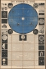

Carte Astronomique de L'Univers.
Teaching astronomy.
$1,250.00
Choose a Collection:
- Digital Map Information
- Suitable for large format printing
- Full resolution TIFF file
- ICC color profile embedded
- Delivered instantly via download link
This Item
Enquire
Teaching astronomy.
This is a dramatic astronomical chart issued in Paris in 1878 by Etienne Laporte. Laporte believed that astronomy was best taught visually, via large charts and diagrams, rather than through more traditional text-only schoolbooks. This chart was thus published for used in schools and by private tutors to teach astronomy.A Closer Look
A large circular map of the Solar System dominates the upper portions of the chart. Planets extend as far as Neptune (discovered in 1846). These, as well as their moons, comets, and some stars, are keyed numerically to the text below. Eight full columns of descriptive text discuss the sun, planets, the moon, and comets. The border on either size is composed of 16 striking illustrations of a mostly astronomical nature.Publication History and Census
This chart was issued in 1878 for Etienne Laporte of Paris. It was lithographed in Brussels by Félix Callewaert Père. We are aware of two major variants and multiple minor variants. The major variants are defined by fully revised images along the right and left, and updated text. It is unclear which variant was issued first, but ours corresponds with the Rumsey example, and we will follow his dating of 1878. Of the minor editions, there are multiple variations on the imprints, with some being in Paris, others in Brussels, and still others with different publishers. The present example was published by Boyères in Paris. Of the two major editions, it is by far the rarest.Cartographer
Etienne Laporte (fl. c. 1850 - 1900) was a lecturer in chemistry and astronomy at the Sorbonne, member of the main learned societies of Europe, associate professor at the University of Oxford. Further Details...
Condition
Good. Some toning, especially along old fold lines. Minor linen separation at points, but he piece remains cohesive and stable.
References
Rumsey 11289.000.