This item has been sold, but you can get on the Waitlist to be notified if another example becomes available, or purchase a digital scan.
1766 De L'Isle Map of North Asia (Tartary, Russia, Siberia, China, Mongolia)
CarteduTartarie-delisle-1766$250.00

Title
Carte de Tartarie.
1766 (dated) 19.5 x 25.5 in (49.53 x 64.77 cm) 1: 10700000
1766 (dated) 19.5 x 25.5 in (49.53 x 64.77 cm) 1: 10700000
Description
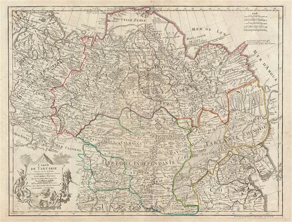
A fascinating 1766 Guillaume Delisle map of Tartary comprising most of Asian Russia, Siberia, Mongolia, Korea, northern China, and Independent Tartary. The map covers the vast expanse of northern Asia from the Black Sea and Gulf of Finland eastward as far as Yeso (Hokkaido), Korea, and China. It extends northwards beyond Nova Zembla and south to include parts of the Caspian Sea, Tibet, the Yangtze Valley, and parts of northern India and modern day Afghanistan. De L'Isle first issued this map in 1706, the present example however exhibits few if any updates (other than the date) and may be assumed to have come from the same printing plate.
Like most maps of this period, De L'Isle derived his map of Asia from primarily from the 1692 work of Nicholas Witsen, though admittedly there are several updates. Witsen was the Mayor of Amsterdam and a powerful director of the Dutch East India Company (VOC). Witsen compiled countless report received from the VOC's many traders operating throughout Asia. He also corresponded extensively with Tsar Petr Alexeyevitch inspiring a new age of Russian cartography. The result was a seminal map and accompanying book entitled Noord en Oost Tartarye that became the definitive resource for the mapping of northeast Asia for the next century.
Witsen describes his map:
Published in the Dezauche 1789 reissue of Delisle's 1731 Atlas de Geographie.
Like most maps of this period, De L'Isle derived his map of Asia from primarily from the 1692 work of Nicholas Witsen, though admittedly there are several updates. Witsen was the Mayor of Amsterdam and a powerful director of the Dutch East India Company (VOC). Witsen compiled countless report received from the VOC's many traders operating throughout Asia. He also corresponded extensively with Tsar Petr Alexeyevitch inspiring a new age of Russian cartography. The result was a seminal map and accompanying book entitled Noord en Oost Tartarye that became the definitive resource for the mapping of northeast Asia for the next century.
Witsen describes his map:
… Answers from the most Northern and North-East parts of the World. For I have maintained constant Correspondence in Moscow, Astracan, Georgia, Yspahan, Polonie, and Constantinople. I have had Letters every year from Pekin, the Chief City of China. I have gathered Volumes of Journals and Registers, which set forth the Names of Mountains, Rivers, Cityes and Towns, together with a vast number of Drafts made by my own order, which describe Territories that I have mentioned. Tis from this Fund, which has been gathering for so many years, and by comparing and adjusting all these Materials, and by persevering without intermission there in, that the Map (of Tartary) is made up…However, Delisle is in no way exclusive in his use of Witsen's work. Many elements of the map are the result his own judicious speculations. Nova Zemble (Nouvelle Zemle), for example, is here rendered as a Peninsula. A strange chain of mountains also extends from the northeastern part of the Continent. Where Witsen notes that it 'has no end,' Delisle makes clear that it does not communicate with America. Hokkaido is mapped speculative as Terre d'Eso and the seas to the north, roughly corresponding to the Sea of Okhotsk, is here identify as the Mer d'Amour. There is also an Ille D'Amour.
Published in the Dezauche 1789 reissue of Delisle's 1731 Atlas de Geographie.
CartographerS
The De L'Isle family (fl. c. 1700 - c. 1760) (also written Delisle) were, in composite, a mapmaking tour de force who redefined early 18th century European cartography. Claude De L'Isle (1644 -1720), the family patriarch, was Paris based a historian and geographer under Nicholas Sanson. De L'Isle and his sons were proponents of the school of "positive geography" and were definitive figures, defining the heights of the Golden Age of French Cartography. Of his twelve sons, four, Guillaume (1675 - 1726), Simon Claude (1675 - 1726), Joseph Nicholas (1688 - 1768) and Louis (1720 - 1745), made a significant contributions to cartography. Without a doubt Guillaume was the most remarkable member of the family. It is said that Guillaume's skill as a cartographer was so prodigious that he drew his first map at just nine years of age. He was tutored by J. D. Cassini in astronomy, science, mathematics and cartography. By applying these diverse disciplines to the vast stores of information provided by 18th century navigators, Guillaume created the technique that came to be known as "scientific cartography", essentially an extension of Sanson's "positive geography". This revolutionary approach transformed the field of cartography and created a more accurate picture of the world. Among Guillaume's many firsts are the first naming of Texas, the first correct map of the Mississippi, the final rejection of the insular California fallacy, and the first identification of the correct longitudes of America. Stylistically De L'Isle also initiated important changes to the medium, eschewing the flamboyant Dutch style of the previous century in favor of a highly detailed yet still decorative approach that yielded map both beautiful and informative. Guillaume was elected to the French Academie Royale des Sciences at 27. Later, in 1718, he was also appointed "Premier Geographe du Roi", an office created especially for him. De L'Isle personally financed the publication of most of his maps, hoping to make heavy royalties on their sales. Unfortunately he met an untimely death in 1728, leaving considerable debt and an impoverished child and widow. De L'Isle's publishing firm was taken over by his assistant, Phillipe Buache who became, posthumously, his son in law. The other De L'Isle brothers, Joseph Nicholas and Louis De L'Isle, were employed in the Service of Peter the Great of Russia as astronomers and surveyors. They are responsible for cataloguing and compiling the data obtained from Russian expeditions in the Pacific and along the northwest coast of America, including the seminal explorations of Vitus Bering and Aleksei Chirikov. The De L'Isles, like their rivals the Vaugondys , must be considered speculative geographers. Speculative geography was a genre of mapmaking that evolved in Europe, particularly Paris, in the middle to late 18th century. Cartographers in this genre would fill in unknown areas on their maps with speculations based upon their vast knowledge of cartography, personal geographical theories, and often dubious primary source material gathered by explorers and navigators. This approach, which attempted to use the known to validate the unknown, naturally engendered many rivalries. The era of speculatively cartography effectively ended with the late 18th century explorations of Captain Cook, Jean Francois de Galaup de La Perouse, and George Vancouver. More by this mapmaker...
Jean-Claude Dezauche (1745 - 1824) was a French map publisher active in Paris during the first half of the 19th century. He established his own engraving firm around 1770 after having engraved music since 1762. Dezauche bought the archives of Phillipe Buache and Guillaume de L'Isle from Jean Nicholas Buache, Buache's heir, in 1780. Dezauche soon obtained a monopoly on selling the charts produced by the Dépôt de la Marine. Jean-Claude Dezuache passed his business to his son, Jean André Dezauche, upon his death, who took over selling the Dépôt de la Marine charts. Learn More...
Source
Delisle, G., and Buache, P., Atlas Geographique et Universel, (Dezauche, Paris), 1789.
Condition
Very good. Original centerfold. Pressmark visible. Blank on verso. Wide clean margins.
References
Rumsey 4764.087.