1863 Collinson / Admiralty Nautical Chart / Map of Guangdong Coast, China
ChelangChauan-admiralty-1863$950.00

Title
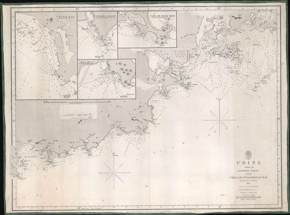
China Sheet III. Eastern Coast from Chelang Pt. to Chauan Bay.
1863 (dated) 19.5 x 26.25 in (49.53 x 66.675 cm) 1 : 30500
1863 (dated) 19.5 x 26.25 in (49.53 x 66.675 cm) 1 : 30500
Description
This is a rare 1863 British Admiralty nautical map of Guangdong, China, by Sir Richard Collinson. It was issued in the wake of the Second Opium War (1856 - 1860) and the signing of the 1860 Convention of Peking - an event that led to an explosion of foreign trade with China.
The Convention of Peking, which ended the Second Opium War, comprised three distinct treaties. Each Western power (Great Britain, France, and the Russian Empire) demanded separate treaties with their own special stipulations. Britain demanded the concession of Kowloon and the legalization of opium, while France secured freedom of religion in China. The Russian Empire, although not a belligerent in the war, gained parts of Outer Manchuria.
A Closer Look
Coverage embraces the Chinese coast from Chelang Point (near Jieshi Bay) to Chauan Bay (Zhao'an Bay) - essentially the modern-day Guangdong coast just east of Hong Kong. There are countless depth soundings throughout, with points, bays, capes, islands, and other features identified. Four insets detail Chino Bay, Cupchi Point, Hai Mun, and the Cape of Good Hope.Second Opium War
The Second Opium War (October 8, 1856 - October 24, 1860) followed the First Opium War (1839 - 1842), both pitting a British-French alliance against Qing China. Both wars resulted in Qing defeats. The Chinese capture of the British cargo vessel Arrow ignited the Second Opium War. Following the seizure of the Arrow, Britain destroyed a series of forts and bombarded Canton (Guangzhou). Over the ensuing four years, the war progressed through several phases and ended with the British and French occupying Beijing after handing the Chinese a devastating defeat. While in Beijing, British and French troops looted the Summer Palace and the Old Summer Palace. In an incomparable causality of war, Lord Elgin of Great Britain, Russian envoy Count Ignatiev, and French diplomat Baron Gros ordered the Summer Palace burned. Lord Elgin advocated for the destruction of the Forbidden City as well, as revenge for the mistreatment of Western prisoners (almost 20 were tortured and murdered, including two British envoys and a journalist for The Times), but Ignatiev and Gros convinced Elgin that burning the Summer Palaces was sufficient and less objectionable.The Convention of Peking, which ended the Second Opium War, comprised three distinct treaties. Each Western power (Great Britain, France, and the Russian Empire) demanded separate treaties with their own special stipulations. Britain demanded the concession of Kowloon and the legalization of opium, while France secured freedom of religion in China. The Russian Empire, although not a belligerent in the war, gained parts of Outer Manchuria.
Publication History and Census
This map was created from surveys conducted by Royal Navyman Richard Collinson and published by the British Admiralty. It was first published in 1849. It represents sheet III of a numbered set covering the China coast (Sheet II is Hong Kong). Several editions followed, including an edition published in 1863, of which the present example is an example. The only other known example of this chart is part of the collection at the National Maritime Museum in Greenwich, London.CartographerS
The British Admiralty Office (1795 - Present) or the United Kingdom Hydrographic Office refers to the Branch of the English government that is responsible for the command of the British Navy. In 1795 King George III created the United Kingdom Hydrographic Office, known in short as the U.K.H.O., to provide top notch nautical charts to the vast Royal Navy. Prior the founding of the Admiralty the surveying and creation of nautical charts was primarily a commercial venture wherein the cartographer himself, more of than not, actually financed the printing of his own material. The great navigator Cook himself is known to have scrambled for funds to publish his own seminal charts - the most important and advanced of the period. The system of privately funded nautical mapping and publishing left vast portions of the world uncharted and many excellent charts unpublished. King George III, responding significant loss in trade revenue related to shipwrecks and delay due to poor charts, recognized the need for an institutionalized government sponsored cartographic agency - the Admiralty. The first head of the Admiralty, a position known as Hydrographer, was the important cartographer Alexander Dalrymple. Dalrymple started by organizing and cataloging obtainable charts before initiating the laborious process of updating them and filling in the blanks. The first official Admiralty Chart appeared in 1800 and detailed Quiberon Bay in Brittany. By 1808 the position of Hydrographer fell to Captain Thomas Hurd. Hurd advocated the sale of Admiralty charts to the general public and, by the time he retired in 1829, had issued and published some 736 charts. Stewardship of the organization then passed to Rear Admiral Sir Francis Beaufort. It was under Beaufort's administration that the Admiralty truly developed as a "chart making" as opposed to a "chart cataloging" institution. Beaufort held his post from 1829 to 1854. In his 25 years at the Admiralty Beaufort created nearly 1500 new charts and sponsored countless surveying and scientific expeditions - including the 1831 to 1836 voyage of the H.M.S. Beagle. By 1855 the Admiralty's chart catalog listed some 1,981 charts. More by this mapmaker...
Richard Collinson (November 7, 1811 – September 13, 1883) was an English naval officer, marine surveyor, and Arctic explorer. He was born in Gateshead, Tyne and Wear, England, then part of Durham. He joined the Royal Navy in 1823, at age twelve, and rose in the ranks, becoming a lieutenant in 1835, commander in 1841, and captain in 1842. Collinson was a highly capable captain. He participated with distinction in the First Opium War (1839 - 1842). After the war, along with Commander Henry Kellett, he completed a series of pioneering surveys of the China coast from the Yangtze River to Hong Kong. These he completed between 1842 and 1846 while serving as commander of the HMS Plover. In 1850, he was sent north in command of the HMS Enterprise to search for survivors of the Sir John Franklin expedition. Although he came quite close, he never found Franklin's lost men and returned to England without success. Nonetheless, he was honored by the Royal Geographical Society for his surveys in the Arctic and proof that it was navigable from the Behring Strait to King William's Land. Collinson was Knighted in 1875, the same year in which he retired from active duty with the rand of Admiral. Collinson died in September of 1883. Learn More...
John Walker (1787 - April 19, 1873) was a British map seller, engraver, lithographer, hydrographer, geographer, draughtsman, and publisher active in London during the 19th century. Walker published both nautical charts and geographical maps. His nautical work is particularly distinguished as he was an official hydrographer for the British East India Company, a position, incidentally, also held by his father of the same name. Walker's maps, mostly published after 1827, were primarily produced with his brothers Charles Walker and Alexander Walker under the imprint J. and C. Walker. Among their joint projects are more than 200 maps for the influential Society for the Diffusion of Useful Knowledge Atlas (SDUK). In addition they published numerous charts for James Horsburgh and the British Admiralty Hydrographic Office, including Belcher's important map of Hong Kong and Carless' exploratory map of Karachi. The J. and C. Walker firm continued to publish after both Walkers died in the 1870s. Learn More...
Condition
Very good. Even overall toning. Mounted on linen.
References
National Maritime Museum, Greenwich, London G271:8/4.