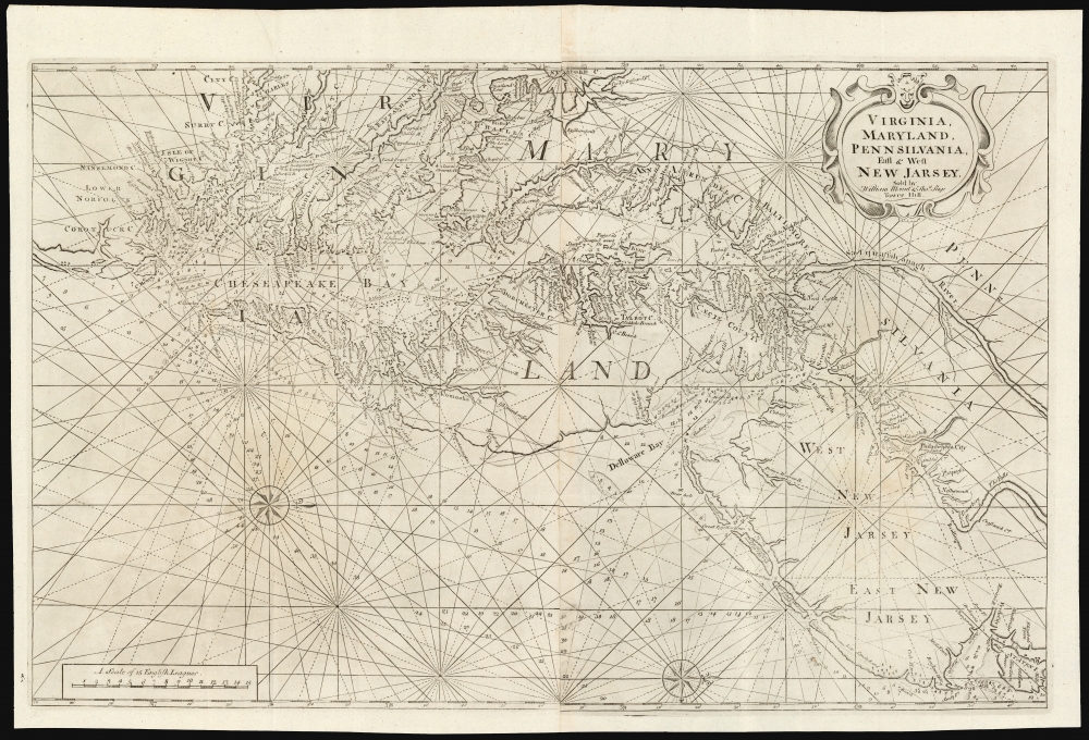
1742 William Mount and Thomas Page Nautical Chart of Chesapeake Bay
Chesapeake-mountpage-1742$4,000.00


Title
Virginia, Maryland, Pennsilvania, East and West New Jarsey...
1742 (undated) 19.75 x 31.25 in (50.165 x 79.375 cm) 1 : 600000
1742 (undated) 19.75 x 31.25 in (50.165 x 79.375 cm) 1 : 600000
Description
This is a superb example of William Mount and Thomas Page's large nautical map of the Chesapeake Bay and Delaware Bay in the 1742 first state. It represents the dominant English depiction of the water approaches to Virginia, Maryland, Delaware, and New Jersey for most of the Colonial Period.
While it does identify the colonies, and names the counties within them, as a chart the work is focused on waterways and does not include detail of the interior, such as cities and roads. The chart is abundantly marked with rhumb lines and depth soundings and sports two elegant compass roses.
A Closer Look
The map's basic outline was derived from Augustine Hermann's 1673 Virginia and Maryland. Coolie Verner considered Thornton's Virginia chart 'a careful and exact copy of the Herman (sic)', but it was augmented in the north from other sources, as were its array of depth soundings and shoals. The westward-oriented chart covers the mid-Atlantic coast, from Staten Island to Virginia Beach. It includes the lower reaches of the Susquehanna and Delaware Rivers. The Potomac is depicted as far as what is here termed Turkey Buzzard Point. Not to be mistaken for the modern peninsula of that name on the Patuxent River, Turkey Buzzard Point was later shortened to Buzzard Point, which overlooks the juncture of the Potomac and Anacostia Rivers and constitutes the southernmost tip of present-day Washington, D.C.While it does identify the colonies, and names the counties within them, as a chart the work is focused on waterways and does not include detail of the interior, such as cities and roads. The chart is abundantly marked with rhumb lines and depth soundings and sports two elegant compass roses.
Publication History and Census
Initially engraved in 1689 by John Thornton, for inclusion in his Atlas Maritimus. After a long run in that nautical atlas, the plate passed to Mount and Page just prior to Thornton's death in 1707-8, after which they began to publish the chart in their The English Pilot. The age of the plates necessitated their re-engraving to two new ones in and around 1742. The easiest point of recognition for these second plate examples is the lettering 'VIR GIN IA' for that colony's name. Coolie Verner's cartobibliography of the Virginia maps appearing in The English Pilot enumerates two states for the second plate of the chart. The 1773 second state of the second plate exhibited the changed spelling of the place name 'Jarsey' to 'Jersey' as well as sporting a longer tail in the 'g' of Page's imprint. The spelling 'Jarsey' appearing on this example, as well as the long tail of the 'g', identifies this as the first state of the second plate. Examples of this version of the map were included in editions of The English Pilot from 1743 to 1770. The English Pilot is well represented in institutional collections, but we see just four separate examples of this state of the chart in OCLC.CartographerS
John Thornton (October 8, 1641 - January 23, 1708) was a British chartmaker, sea captain, publisher and engraver active in London during the late 18th and early 19th centuries. Thornton apprenticed to John Burston where mastered the art of manuscript maritime cartography as practiced by the Thames School. By the 1660s Thornton, working with John Seller and William Fisher, began publishing printed nautical charts and was the only Thames School cartographers to successfully transition to print. Thornton published numerous maps both independently and with some of the most prominent British publishers of his day, including the aforementioned as well as Herman Moll, Robert Morden, James Clark, Robert Greene, and Philip Lea. From around 1665 Thornton took over from Seller the production of the English Pilot. Upon his death in 1708 Thornton willed his charts, copper plates, instruments, and 'all things belonging to my calling' to his son, Samuel Thornton, who continued to republished his father's work, with few updates, until about 1715. More by this mapmaker...
Mount and Page (fl. 1701 - 1760) was a London based firm of religious and maritime publishers that flourished in the 18th century. With the publication of the 1732 English Pilot, the Mount and Page name became well-known worldwide as an imprint of nautical charts. The firm was founded at Tower Hill, London, in 1701 by Richard Mount (1654 - 1722) and his apprentice Thomas Page (1780 - March 15, 1733). Mount had previously been in partnership with his father-in-law William Fisher (1631 - 1691) and inherited the business on the latter's death. Page completed his apprenticeship in 1716. Now fully partnered, Mount and Page subsequently acquired the map plates several defunct British nautical chart publishers, including Greenville Collins, Jeremiah Seller, Charles Price, and John and Samuel Thornton - thus nearly monopolizing the British nautical chart business. The firm consequently received several lucrative government contracts and thereby flourished throughout the 18th century, making the fortunes of both families. Successive generations of Mounts and Pages worked in the business, and the families intermarried. Its staple titles were The English Pilot and Navigatio Britannica by John Barrow. By the 1760s, Richard Mount's grandson John Mount (1725 - 1786) was able to retire to Berkshire where he built the stately mansion, Wasing Place. John's son William (1753 - 1815) was the last to work in the map business, and later generations went into politics. Learn More...
Source
Mount, W. and Page, T., The English Pilot. The Fourth Book, (London) 1743-1770.
The English Pilot, published from 1671 to 1794, was the brain child of John Seller (1630 – 1697). Seller, recognizing a lack of quality English-made nautical charts, began to compile and engrave charts for a new maritime atlas as early as 1669. That same year he announced the publication of the English Pilot. The work was intended to be published in geographically specific volumes such that only the necessary maps need accompany a voyage. The English Pilot, The First Book, covering English waters, was published in 1671. Despite his claims, most of the maps in the first book were not English productions, but rather worn out Dutch map plates purchased as scrap and then retooled with Seller's imprint. Nonetheless, the work proved popular among merchant seamen and earned him the title 'Hydrographer in Ordinary' as well as copyright protection for 30 years. Seller failed to fully realize his grand scheme but it was picked up in earnest by other cartographers, including William Fisher, John Thornton, John Wingfield, Richard Mount and Thomas Page. Subsequent volumes followed including The Second Book, covering the Mediterranean; The Third Book covering African and Arabian coasts; The Fourth Book comprising the first British atlas exclusively dedicated to the Americas; The Fifth Book, a volume of practical Navigation; and The Sixth Book focusing on East Asian waters. The English Pilot was issued in over 40 editions with a print run exceeding 100 years. It was also pirated by George Grierson and published in Dublin under his imprint. It is one of the most important British atlases ever published.
Condition
Excellent. Some very faint glue toning at juncture of two sheets, else a fine, undamaged example with complete margins.
References
OCLC 58401035. Burden, P. The Mapping of North America II 667. Verner, C. A Carto-Bibliographical Study of The English Pilot The Fourth Book with special reference to The Charts of Virginia pp. 29-40 Phillips, P. Maps of America, p. 227. Sellers, John R. and Van Ee, Patricia, Maps and Charts of North America, no. #719. Wooldridge, W., Mapping Virginia from the Age of Exploration to the Civil War, no 89.