
1775 / 1823 Robert Laurie Map of China and Korea (Sea of Korea)

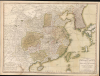

The Empire of China, with its Principal Divisions; Drawn from the Surveys mad by the Jesuits: with Improvements and Additions, from the Maps of Monsr. D'Anville.
Sea of Korea and the Pratas Islands.
- Digital Map Information
- Suitable for large format printing
- Full resolution TIFF file
- ICC color profile embedded
- Delivered instantly via download link
Sea of Korea and the Pratas Islands.
This is a large, elegant 1823 map of China and Korea, produced by Robert Laurie. Initially published in 1775, the map features updates executed over the course of the subsequent decades. Among its notable features is the naming of the body of water between Korea and Japan as the 'Corean Sea'.A Closer Look
Coverage embraces from Chinese Tartary to the Gulf of Tonkin and the Philippines, and from the Gobi Desert to Korea. The westernmost parts of Japan also appear. The map includes Taiwan, along with parts of Tibet and Tartary. China proper is divided into various provinces by color coding. Several segments of the Great Wall of China are indicated. The sea between Japan and Korea (a matter of historical and political dispute between the countries) is here identified in favor of Korea.Pratas Island
Among the information added to the 1790 Laurie and Whittle edition is the Pratas Island in the South China Sea (also known as the Tungsha or Dongsha Island). The atoll, now Taiwanese territory, has been the subject of counter-claims by the People's Republic of China, and Pratas remains a focal point for conflict in the region.Cartography in Transition
The map's detail was derived from Jean-Baptiste Bourguignon D'Anville' s 1752 Seconde partie de la carte d'Asie. Stylistically, this map presages the functional English school of cartography that would develop in the early 19th century under the patronage of Cary, Thomson, and Pinkerton. This development, for which this piece represents a transitional phase, eschewed the decorative embellishments of the 18th century in favor of cartographic accuracy and additional detail.Sea of Korea vs. Sea of Japan
The sea between Japan and Korea, whose name, either the 'Sea of Korea,' 'East Sea,' or the 'Sea of Japan,' is here identified in favor of Korea (Corean Sea). Historically, Korea has used the term 'East Sea' since 59 B.C., and many books published before the Japanese annexed Korea make references to the 'East Sea' or 'Sea of Korea.' Over the centuries, neighboring and Western countries have referred to Korea's East Sea by various terms. The St. Petersburg Academy of Sciences referred to the East Sea as 'Koreiskoe Mope' or 'Sea of Korea' in their 1745 map of Asia. Other 17th and 18th-century Russian maps alternate between 'Sea of Korea' and 'Eastern Ocean.' The 18th-century Russian and French explorers Adam Johan von Krusenstern and La Perouse called it the 'Sea of Japan,' a term that became popular worldwide. Nonetheless, the last official map published by the Russians named the East Sea the 'Sea of Korea.' The name is currently still a matter of historical and political dispute between the countries.Publication History and Census
The map was engraved by Morris Bowen (fl. 1772 - 1775) and published in 1775 by Sayer and Bennett. That firm's inheritors, Laurie and Whittle, edited the map and continued its publication in several issues of their Imperial Atlas. After Whittle's death, Robert Laurie continued the business under his own imprint, as here in this 1823 issue. We see 9 examples cataloged separately in institutional collections; the map appears on the market from time to time.Cartographers
Laurie and Whittle (fl. 1794 - 1858) were London, England, based map and atlas publishers active in the late 18th and early 19th century. Generally considered to be the successors to the Robert Sayer firm, Laurie and Whittle was founded by Robert Laurie (c. 1755 - 1836) and James Whittle (1757-1818). Robert Laurie was a skilled mezzotint engraver and is known to have worked with Robert Sayer on numerous projects. James Whittle was a well-known London socialite and print seller whose Fleet Street shop was a popular haunt for intellectual luminaries. The partnership began taking over the general management of Sayer's firm around 1787; however, they did not alter the Sayer imprint until after Sayer's death in 1794. Apparently Laurie did most of the work in managing the firm and hence his name appeared first in the "Laurie and Whittle" imprint. Together Laurie and Whittle published numerous maps and atlases, often bringing in other important cartographers of the day, including Kitchin, Faden, Jefferys and others to update and modify their existing Sayer plates. Robert Laurie retired in 1812, leaving the day to day management of the firm to his son, Richard Holmes Laurie (1777 - 1858). Under R. H. Laurie and James Whittle, the firm renamed itself "Whittle and Laurie". Whittle himself died six years later in 1818, and thereafter the firm continued under the imprint of "R. H. Laurie". After R. H. Laurie's death the publishing house and its printing stock came under control of Alexander George Findlay, who had long been associated with Laurie and Whittle. Since, Laurie and Whittle has passed through numerous permeations, with part of the firm still extant as an English publisher of maritime or nautical charts, 'Imray, Laurie, Norie and Wilson Ltd.' The firm remains the oldest surviving chart publisher in Europe. Further Details...
Jean Baptiste Bourguignon d'Anville (1697 - 1782) was perhaps the most important and prolific cartographer of the 18th century. D'Anville's passion for cartography manifested during his school years when he amused himself by composing maps for Latin texts. There is a preserved manuscript dating to 1712, Graecia Vetus, which may be his earliest surviving map - he was only 15 when he drew it. He would retain an interest in the cartography of antiquity throughout his long career and published numerous atlases to focusing on the ancient world. At twenty-two D'Anville, sponsored by the Duke of Orleans, was appointed Geographer to the King of France. As both a cartographer and a geographer, he instituted a reform in the general practice of cartography. Unlike most period cartographers, D'Anville did not rely exclusively on earlier maps to inform his work, rather he based his maps on intense study and research. His maps were thus the most accurate and comprehensive of his period - truly the first modern maps. Thomas Basset and Philip Porter write: "It was because of D'Anville's resolve to depict only those features which could be proven to be true that his maps are often said to represent a scientific reformation in cartography." (The Journal of African History, Vol. 32, No. 3 (1991), pp. 367-413). In 1754, when D'Anville turned 57 and had reached the height of his career, he was elected to the Academie des Inscriptions. Later, at 76, following the death of Philippe Buache, D'Anville was appointed to both of the coveted positions Buache held: Premier Geographe du Roi, and Adjoint-Geographer of the Academie des Sciences. During his long career D'Anville published some 211 maps as well as 78 treatises on geography. D'Anville's vast reference library, consisting of over 9000 volumes, was acquired by the French government in 1779 and became the basis of the Depot Geographique - though D'Anville retained physical possession his death in 1782. Remarkably almost all of D'Anville's maps were produced by his own hand. His published maps, most of which were engraved by Guillaume de la Haye, are known to be near exact reproductions of D'Anville' manuscripts. The borders as well as the decorative cartouche work present on many of his maps were produced by his brother Hubert-Francois Bourguignon Gravelot. The work of D'Anville thus marked a transitional point in the history of cartography and opened the way to the maps of English cartographers Cary, Thomson and Pinkerton in the early 19th century. Further Details...
Source
Laurie, R.,A New and Elegant Imperial Atlas, (London: R.H. Laurie), 1823.
Condition
Good. Old repair of surface tear at bottom left; old mounting to stiff paper. Original wash color.
References
Rumsey 2310.070 (1804 edition). University of Southern California, East Asian Map Collection (Corean Sea, David Lee Collection, EAMC 155. Phillips (Atlases) 716.