
This item below is out of stock, but another example (left) is available. To view the available item, click "Details."
Details
1913 War Office Map of China and is Railroads, Telegraphs, and Treaty Ports
$1,400.00
1913 War Office Map of China and is Railroads, Telegraphs, and Treaty Ports
ChinaRailwaysTelegraphs-waroffice-1913$625.00

Title
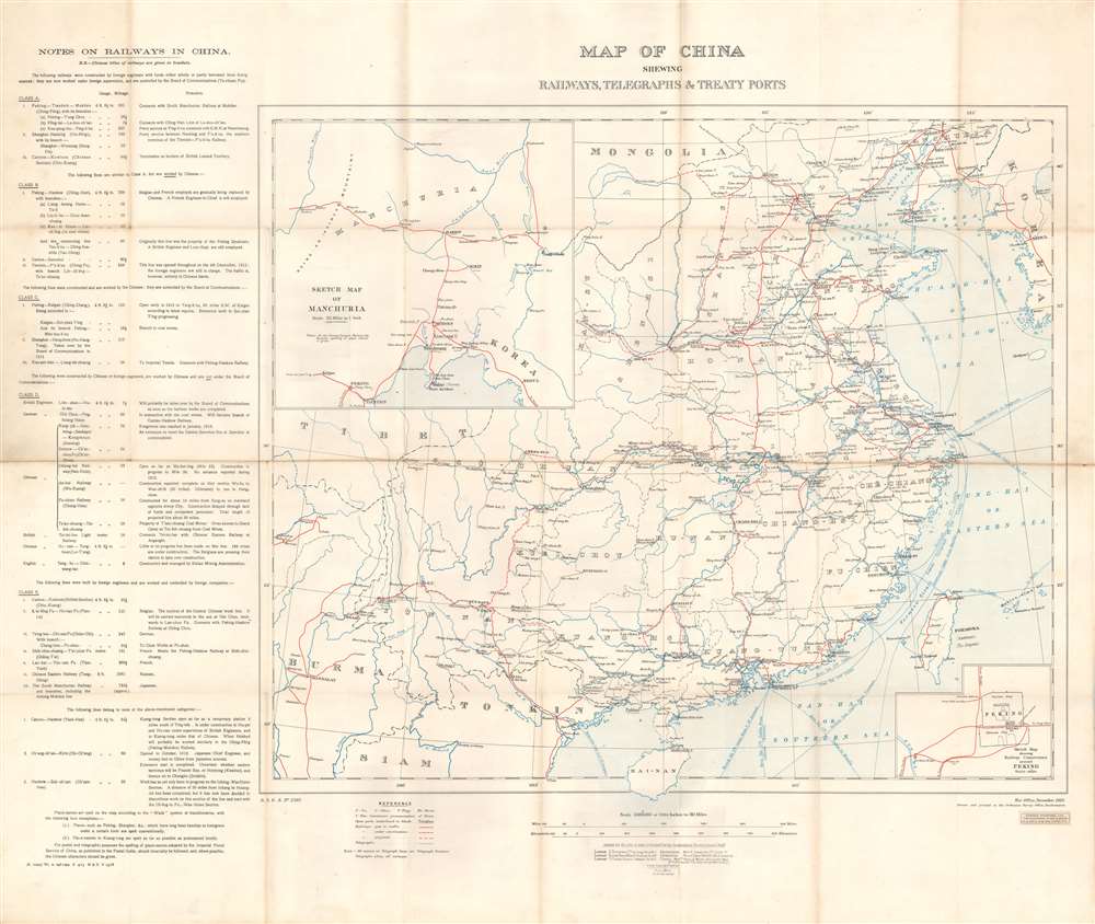
Map of China Shewing Railways, Telegraphs, and Treaty Ports.
1913 (dated) 29.5 x 35 in (74.93 x 88.9 cm) 1 : 5000000
1913 (dated) 29.5 x 35 in (74.93 x 88.9 cm) 1 : 5000000
Description
This is a 1913 British War Office map of China and its railroads, telegraphs, and treaty ports. A system of red lines traces the Chinese railroad network. Solid red lines mark rail lines open to traffic, dashed red and white lines highlight lines currently under construction, and dashed red lines illustrate projected lines. Solid black lines follow telegraph lines. Blue lines in the Yellow Sea, Eastern Sea, and Southern Sea mark undersea cables connecting Chinese ports to other coastal Chinese cities and foreign nations. China's river system is also illustrated and labeled, and many cities along these rivers had been opened to foreign trade, a detail indicated by whether or not the city is underlined. An inset in the lower right details Peking, including the divisions of the Chinese City, Tartar City, and Imperial City. A second inset in the upper left corner illustrates railway connections in Manchuria that connect with Vladivostok and the Trans-Siberian Railway in Russia.
Railroads in China
The first railway to be built in China was a 600-meter narrow-gauge demonstration line that a British merchant assembled in Beijing in 1864 in hopes of securing a national contract from the Qing. The Emperor was unimpressed and ordered the railroad disassembled. The next effort, again by the British, was built in 1876, without Qing approval, between Shanghai and Woosung (Baohan, Shanghai). Following the First Sino-Japanese War (1894 - 1895), the Qing began to recognize the advantage of railroads, and modern technology in general, and began granting construction contracts. Railroad construction continued throughout the remaining years of the Qing and during the Republic of China Period (1912 - 1949). During the Second Sino-Japanese War (1939 - 1945), Japanese companies also built numerous railroads in the occupied territories. After the establishment of the People's Republic of China in 1949, the new government under Mao Zedong invested heavily in the railway network. From the 1950s to the 1970s, railroad lines throughout the country were dramatically expanded. Some lines, particularly in the mountainous regions of southern and western China, were not completed until recently.Publication History and Census
This map was created by the British Ordnance Survey Office in Southampton for the British War Office and published in November 1913. The OCLC catalogs over a dozen in institutional collections worldwide, including the collections at the Library of Congress, Yale University, Princeton University, the National Library of Scotland, the University of Cambridge, The British Library, and the Bibliothèque nationale de France. It is nonetheless extremely scarce on the market.CartographerS
The British War Office (1857 - 1964) was a department of the British Government responsible for the administration of the Royal Army until 1964, when its functions were transferred to the Ministry of Defense. The War Office was to the Royal Army what the Admiralty was to the Royal Navy, and later, the Air Ministry. Within the War Office, the General Staff Topographical Section was responsible for thousands of maps issued for British intelligence and military use. The Topographical Section was renamed Geographical Section in April 1907. Many, once their military use passed, were offered through licensed agents to the general public. The sole London agent for War Office material was Edward Stanford. More by this mapmaker...
Edward Stanford (May 27, 1827 - November 3, 1904) was one of the most prolific map publishing firms of the late 19th century. The company began as a partnership in 1848 between the 21 year old Edward Stanford and the established map dealer Trelawney Saunders. By 1853 the partnership had dissolved and Edward Stanford took full control of the business. A subsequent series of expansions and exciting new map issues finally led to the production of Stanford's masterwork, "Stanford's Library Map of London". This map is still available and remains somewhat accurate. At the time of publishing it was hailed by the Royal Geographical Society as "the most perfect map of London that has ever been issued". In 1882 Edward Stanford Sr. passed the firm on to his son, Edward Stanford Jr. who continued in his father's proud tradition. Today the Stanford firm still publishes maps and remains one of the most important and prolific cartographic publishers in the world. Learn More...
The British Ordnance Survey (1791 - present) is the national mapping agency of Great Britain and is one of the largest producers of maps in the world. This non-ministerial department of the government of the United Kingdom is responsible for producing maps of Great Britain and many of its overseas possessions. The history of the Ordnance Survey goes back as far as 1747, following the Jacobite rising, when King George II commissioned a comprehensive military survey of Scotland to assist further campaigns. The result, produced by Paul Sandby, John Mason and William Roy, was the Duke of Cumberland's Map, the first military quality map of the British Isles. This grew into the Principal Triangulation of Great Britain (1783-1853) under William Roy, and eventually lead to the creation of the Ordnance Survey in 1791. Today the Ordnance Survey produces a large variety of paper maps and digital mapping products. Its large scale maps, issued to the scale of 1:10000, available in sheet map form until the 1980s, are now only available digitally. All maps produced by the Ordnance Survey are in copyright for 50 years after publication. Learn More...
Condition
Very good. Mounted on linen. Exhibits wear along original fold lines and at fold intersections. Exhibits toning along original fold lines.
References
OCLC 45907927.